Related Keywords
vertical downloadsvertical scroll downloads
vertical news scrolling downloads
vertical thinking downloads
vertical menu downloads
vertical panoramas downloads
vertical crossword downloads
vertical shooter downloads
vertical scrolling downloads
vertical files downloads
vertical jump progam downloads
vertical jump downloads
vertical css menu downloads
vertical database downloads
vertical blinds downloads
vertical jalousie downloads
vertical menu css downloads
vertical accordion menu downloads
vertical drop down menu downloads
vertical flash menu downloads
Top Software Keywords
autocad downloads3d cad downloads
cad downloads
drawing downloads
import downloads
design downloads
dwg downloads
pdf to dwg downloads
dxf downloads
convert downloads
convert pdf to dwg downloads
dwg to pdf downloads
dxf to pdf downloads
converter downloads
pdf to dxf downloads
dwf to dwg downloads
dwg to dxf downloads
dwg converter downloads
dwg to jpg downloads
dwg to bmp downloads
stl downloads
dxf to pcl downloads
dwg to tiff downloads
intellicad downloads
pdf to cad downloads
dwg to gif downloads
convert dwg to pdf downloads
dwg to png downloads
dwg to dwf downloads
dxf to ps downloads
Vista Download
Vista downloadVista antivirus download
Vista wallpaper download
Vista wallpapers download
Vista themes download
Vista pack download
Vista ultimate download
Vista home download
Vista basic download
Vista business download
Vista x64 download
Vista transformation download
Vista transformation pack download
Vista boot download
Vista dvd download
Vista sidebar download
Vista aero download
Vista product key download
Downloads RSS
Top Downloads
Top Rated
Navigation: Home
\ Graphic Apps
\ CAD \ MountainsMap Scanning Topography
MountainsMap Scanning Topography6.2.6266 by Digital Surf |

|
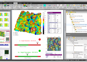
Software Description:
MountainsMap Scanning Topography is a professional application designed to perform surface analysis for 3D surface profilometers. With MountainsMap Scanning Topography, users will be able to easily analyze measurements and metrology data. It features an extensive set of surface texture parameters. ...
type: Trialware
Download MountainsMap Scanning Topographycategories: surface profilometer, scanning opography, surface analysis, topography, profilometer, surface Add to Download Basket Report virus or spyware |
 [ Zoom screenshot ] |
|
| Software Info | |
|
Best Vista Download periodically updates pricing and software information of MountainsMap Scanning Topography full version from the publisher,
but some information may be out-of-date. You should confirm all information. Software piracy is theft, using crack, warez passwords, patches, serial numbers, registration codes, key generator, keymaker or keygen for MountainsMap Scanning Topography license key is illegal and prevent future development of MountainsMap Scanning Topography. Download links are directly from our mirrors or publisher's website, MountainsMap Scanning Topography torrent files or shared files from rapidshare, yousendit or megaupload are not allowed! |
|
| Released: | September 29, 2014 |
| Filesize: | 511.00 MB |
| Platform: | Windows XP, Windows Vista, Windows Vista x64, Windows 7, Windows 7 x64 |
| Install | Instal And Uninstall |
| Add Your Review or Windows Vista Compatibility Report |
MountainsMap Scanning Topography- Releases History |
| Software: | MountainsMap Scanning Topography 6.2.6266 |
| Date Released: | May 3, 2012 |
| Status: | New Release |
| Release Notes: | Surface partitioning with or without leveling: · A sub-surface can be extracted with or without leveling using the Partition Leveling operator. Contour Analysis/Advanced Contour Analysis module enhancements: · Horizontal contour extraction with smoothing - parametric profiles extracted on the XY plane can be smoothed automatically. Integration of Chinese GB/T standards: · The "right parameters wherever you are" feature has been extended to include Chinese GB/T standard references for parameter families, which can be selected in Metrological Preferences - References. Advanced Contour Analysis module enhancements: · Automatic association of geometric elements with profiles - line segments, arcs and circles (greater than a specified minimum size) can be automatically associated with profiles. This significantly speeds up the definition of nominal form (which is otherwise carried out interactively or by fitting CAD DXF data to the profile). |
Most popular vertical in CAD downloads for Vista |
|
Sailcut CAD 1.3.5 download by Jeremy Laine&Robert A. Laine
... able to do cross cut, twist foot cut, vertical cut, mitre cut and radial cut sail design as well as wing sails, all in a number of languages. It also ...
type: Open Source
View Details
Download
categories: sail design, design sail, develop sail, design, develop, development, SailcutCAD |
 |
|
GGCad 2.1.0.5 download by GGSoft
... · Object positionning to another · Horizontal · Vertical · Joint an object to another · Object division · Symmetry · Rotation · Scaling · Moving · Offset · Path ...
View Details
Download
|
 |
|
MountainsMap Scanning Topography 6.2.6266 download by Digital Surf
... minimize stylus or spot shape impact. Increase vertical range virtually Increase vertical range by manually patching together overlapping measurements on the vertical axis. The most popular 2D and 3D ...
type: Trialware
View Details
Download
categories: surface profilometer, scanning opography, surface analysis, topography, profilometer, surface |
 |
|
Projectile Motion (Galileo and Newton) download by Todd Timberlake
... to the projectile initial horizontal velocity component, and vertical motion with constant acceleration and an initial velocity equal to the projectile's initial vertical velocity component. The second view, described by Newton ...
type: Freeware
View Details
Download
categories: motion simulator, projectile simulator, motion simulation, motion, simulation, projectile |
") |
|
Geogiga Front End 9.0 download by Geogiga Technology Corp.
... mute seismic traces, run frequency filter, gain control, vertical stacking, and such. Some batch commands are available, ... the preview of layout chart Analyze amplitude decay Vertical stacking Correct trigger delay Pick first breaks Swap ...
type: Freeware
View Details
Download
categories: preprocess seismic data, analyze amplitude decay, correct trigger delay, viewer, editor, correct |
 |
|
Gerbview x64 10.21 download by Software Companions
... Ortho mode for fast drawing of horizontal and vertical markup lines. Markup burn-in feature for converting markup elements to Gerber data. Delete selection of items from a Gerber file. Command ...
type: Trialware ($80.00)
View Details
Download
categories: x64 print Gerber image, view plot x64, convert Gerber x64, convert x64, Gerber x64, print x64 |
 |
|
DWG FastView Plus 1.0 download by Gstarsoft Co.,Ltd.
... quick measure to display the linear horizontal and vertical measurements of closed objects temporarily. Easy control of Drawing layers and external reference, manage object properties through palettes and search text ...
View Details
Download
|
 |
|
Panoply 5.4.3 download by Robert B. Schmunk
Panoply is a cross-platform application which plots geo-gridded arrays from netCDF, HDF and GRIB datasets. Panoply is a cross-platform software application whose purpose is to help you plot raster images. It ...
type: Freeware
View Details
Download
categories: plot raster image, longitude image, pole-to-pole image, raster image, rasterize, raster |
 |
|
Br3D 1.3 download by HaNee Soft
... Create contour Export(LandXML 1.2), Import(LandXML 1.2) Dimension Horizontal, Vertical, Aligned, Radius, Diameter, Leader Edit Delete, Move, Copy, Scale, Rotate, Offset, Mirror, Explode, Trim, Fillet, Chamfer, Align, Block Edit 3D Union, ...
View Details
Download
|
 |