Related Keywords
survey downloadssurvey software downloads
survey builder downloads
survey online downloads
survey system downloads
survey research downloads
survey engine downloads
survey eangine software downloads
survey builder xcart module downloads
survey builder zencart module downloads
survey aggregator downloads
survey for money downloads
survey for cash downloads
survey in sharepoint downloads
survey maker downloads
survey tool downloads
survey developer downloads
survey analysis downloads
survey rocket plugin downloads
survey valuation system downloads
Top Software Keywords
autocad downloadscad downloads
3d cad downloads
drawing downloads
import downloads
design downloads
dwg downloads
pdf to dwg downloads
dxf downloads
convert downloads
convert pdf to dwg downloads
dwg to pdf downloads
converter downloads
dxf to pdf downloads
pdf to dxf downloads
dwf to dwg downloads
dwg to dxf downloads
dwg converter downloads
dwg to jpg downloads
dwg to bmp downloads
stl downloads
dxf to pcl downloads
dwg to tiff downloads
intellicad downloads
pdf to cad downloads
dwg to gif downloads
convert dwg to pdf downloads
dwg to png downloads
dwg to dwf downloads
dxf to ps downloads
Vista Download
Vista downloadVista antivirus download
Vista wallpaper download
Vista wallpapers download
Vista themes download
Vista pack download
Vista ultimate download
Vista home download
Vista basic download
Vista business download
Vista x64 download
Vista transformation download
Vista transformation pack download
Vista boot download
Vista dvd download
Vista sidebar download
Vista aero download
Vista product key download
Downloads RSS
Top Downloads
Top Rated
Navigation: Home
\ Graphic Apps
\ CAD \ UCL Depthmap
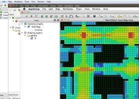
UCL Depthmap0.8.0 by University College London |

|
Software Description:
Depthmap is a single software platform to perform a set of spatial network analyses designed to understand social processes within the built environment. It works at a variety of scales from building through small urban to whole cities or states. ...
type: Open Source
Download UCL Depthmapcategories: urban environment, urban map, spatial network analysis, environment, map, analysis Add to Download Basket Report virus or spyware |
 [ Zoom screenshot ] |
|
| Software Info | |
|
Best Vista Download periodically updates pricing and software information of UCL Depthmap full version from the publisher,
but some information may be out-of-date. You should confirm all information. Software piracy is theft, using crack, warez passwords, patches, serial numbers, registration codes, key generator, keymaker or keygen for UCL Depthmap license key is illegal and prevent future development of UCL Depthmap. Download links are directly from our mirrors or publisher's website, UCL Depthmap torrent files or shared files from rapidshare, yousendit or megaupload are not allowed! |
|
| Released: | November 08, 2020 |
| Filesize: | 35.10 MB |
| Platform: | Windows XP, Windows Vista, Windows Vista x64, Windows 7, Windows 7 x64, Windows 8, Windows 8 x64, Windows 10, Windows 10 x64, Windows 11 |
| Install | Instal And Uninstall |
| Add Your Review or Windows Vista Compatibility Report |
UCL Depthmap- Releases History |
| Software: | UCL Depthmap 0.8.0 |
| Date Released: | Nov 8, 2020 |
| Status: | New Release |
| Release Notes: | General: Allow for pushing values from shapemaps (axial maps, segment maps) to VGA Fix VGA map connections export Make drawing to segment conversion faster Test and fix shape removal for axial and data maps Allow pushing the Ref or Key value to another layer Fix MIF/MID import (allow for empty columns, PR #369) Fix diagonal line handling on VGA map fill (PR #326, thanks Piotr Piastucki!) Change C++ standard to 17 Graphical User Interface (GUI): Highlight shapes and pixels on hover (can be disabled in the settings) Allow inserting any number in the table (PR #356) Fix a case where the app would crash with multiple unlinking in VGA (PR #328) Fix convex map hover and selection (PR #368) Allow generating multiple isovists by importing a CSV file Fix a case where VGA progress bar would end, but analysis would still be going (PR #323) |
| Software: | UCL Depthmap 0.7.0 |
| Date Released: | Jun 7, 2019 |
| Status: | New Release |
| Software: | UCL Depthmap 0.30 |
| Date Released: | Sep 18, 2014 |
| Status: | New Release |
Most popular survey in CAD downloads for Vista |
|
Translev 4.16.0 download by National Geodetic Survey
... VERTOBS datasets for submission to the National Geodetic Survey (NGS). The program includes many built-in functions such as predicting temperature differences, refaction corrections, rod corrections and plotting. Also included are ...
type: Freeware
View Details
Download
categories: generate Blue Book, create VERTOBS report, geodetic report, generate, create, report |
|
CADopia 23 Standard 22.3.1.4100 download by CADopia
CADopia 23 Standard (PERPETUAL license) is a full-featured CAD solution. The advanced features in this edition include ACIS 3D solid modeling, customization tools, PDF to DWG conversion, voice notes, and support ...
type: Demo ($595.00)
View Details
Download
categories: corelcad, autocad, intellicad, bricscad, progecad, draftsight, zwcad, dwg viewer, drawing viewer, drawing, dxf, dwg, survey, CAD, drafting |
 |
|
SierraSoft Land 4.0 download by SierraSoft S.r.l.
SierraSoft Land is a BIM software for land survey restitution and analysis. With SierraSoft Land, you can handle land survey of any size carried out with various types ...
View Details
Download
|
 |
|
CADopia 23 Professional 22.3.1.4100 download by CADopia
CADopia 23 Professional (Perpetual license) is a full-featured CAD solution. The advanced features in this edition include ACIS 3D solid modeling, customization tools, PDF to DWG conversion, voice notes, and support ...
type: Demo ($745.00)
View Details
Download
categories: corelcad, autocad, intellicad, bricscad, progecad, draftsight, zwcad, ARES Commander, dwg viewer, drawing viewer, drawing, dxf, dwg, survey, CAD, drafting, BIM, Revit, fusion 360 |
 |
|
Thuban for Windows 1.2.2 download by Thuban Development Team
... systems as used by the EPSG (European Petroleum Survey Group). For full flexibility projections can be assigned to the map and to each separate layer. Table Management ...
type: Open Source
View Details
Download
categories: geographic data viewer, gis viewer, analyze geographic information, information, geographic, viewer |
 |
|
CADopia 23 Professional 22.3.1.4100 download by CADopia
CADopia 23 Professional (Perpetual license) is a full-featured CAD solution. The advanced features in this edition include ACIS 3D solid modeling, customization tools, PDF to DWG conversion, voice notes, and support ...
type: Demo ($745.00)
View Details
Download
categories: corelcad, autocad, intellicad, bricscad, progecad, draftsight, zwcad, ARES Commander, dwg viewer, drawing viewer, drawing, dxf, dwg, survey, CAD, drafting, BIM, Revit, fusion 360 |
 |
|
DataCAD 20.03.00.04 download by DATACAD LLC.
... most recent American Institute of Architects (AIA) firm survey. FOR THE ARCHITECT . . . DataCAD allows you to draft, edit, and prepare precision construction documents. More than just ...
type: Trialware ($1 295.00)
View Details
Download
categories: cad tool, architectural design, construction creation, CAD, architect, creation |
 |
|
UCL Depthmap 0.8.0 download by University College London
... MID import · OpenStreetMap, Tiger Line and Ordnance Survey ITN layer loaders · Text, SVG and EPS export ...
type: Open Source
View Details
Download
categories: urban environment, urban map, spatial network analysis, environment, map, analysis |
 |
|
Terra Excess 25.1217 download by Terra Excess Software
Terra Excess is land surveying and civil engineering CAD software developed to be ... Terra Excess can generate contour lines from topographic survey data in a very simple way. All you ... AND FILL VOLUMES FOR EARTHWORKS: By using volumetric survey data (sets of points with elevation data), Terra ...
type: Shareware ($298.00)
View Details
Download
categories: land surveying, civil engineering, topographic, contour lines, contour map, triangulated irregular network, earthworks, volumetric, volume calculation, cut and fill, volumes, estimating volumes, survey points, CAD, DXF, quarries, tin surface |
 |
|
FlashPoints 3.0 download by DeliCAD
FlashPoints is a tool for creating and managing points Groups (topographic points for example). FlashPoints allows you to : * import/export points coordinates from and to a file * create points ...
type: Demo ($70.00)
View Details
Download
categories: autocad, cad, dxf, xls, excel, gps, xyz, nxyz, points, import, cogo, survey, coordinates, gis, topography |
 |