Related Keywords
surface downloadssurface test downloads
surface scan downloads
surface mesh downloads
surface fitting downloads
surface area of the body downloads
surface textures downloads
surface map downloads
surface plot downloads
surface modeler downloads
surface profile downloads
surface elevations downloads
surface analyzer downloads
surface rendering downloads
surface profilometer downloads
surface analysis downloads
surface based area calculation downloads
surface tab downloads
surface dist downloads
surface the soaring city downloads
Top Software Keywords
autocad downloads3d cad downloads
cad downloads
drawing downloads
import downloads
design downloads
dwg downloads
pdf to dwg downloads
dxf downloads
convert downloads
convert pdf to dwg downloads
dwg to pdf downloads
dxf to pdf downloads
converter downloads
pdf to dxf downloads
dwf to dwg downloads
dwg to dxf downloads
dwg converter downloads
dwg to jpg downloads
dwg to bmp downloads
stl downloads
dxf to pcl downloads
dwg to tiff downloads
intellicad downloads
pdf to cad downloads
dwg to gif downloads
convert dwg to pdf downloads
dwg to png downloads
dwg to dwf downloads
dxf to ps downloads
Vista Download
Vista downloadVista antivirus download
Vista wallpaper download
Vista wallpapers download
Vista themes download
Vista pack download
Vista ultimate download
Vista home download
Vista basic download
Vista business download
Vista x64 download
Vista transformation download
Vista transformation pack download
Vista boot download
Vista dvd download
Vista sidebar download
Vista aero download
Vista product key download
Downloads RSS
Top Downloads
Top Rated
Navigation: Home
\ Graphic Apps
\ CAD \ MountainsMap Scanning Topography
MountainsMap Scanning Topography6.2.6266 by Digital Surf |

|
Software Description:
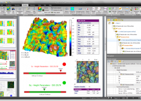
... Topography is a professional application designed to perform surface analysis for 3D surface profilometers. With MountainsMap Scanning Topography, users will be ... metrology data. It features an extensive set of surface texture parameters. ...
type: Trialware
Download MountainsMap Scanning Topographycategories: surface profilometer, scanning opography, surface analysis, topography, profilometer, surface Add to Download Basket Report virus or spyware |
 [ Zoom screenshot ] |
|
| Software Info | |
|
Best Vista Download periodically updates pricing and software information of MountainsMap Scanning Topography full version from the publisher,
but some information may be out-of-date. You should confirm all information. Software piracy is theft, using crack, warez passwords, patches, serial numbers, registration codes, key generator, keymaker or keygen for MountainsMap Scanning Topography license key is illegal and prevent future development of MountainsMap Scanning Topography. Download links are directly from our mirrors or publisher's website, MountainsMap Scanning Topography torrent files or shared files from rapidshare, yousendit or megaupload are not allowed! |
|
| Released: | September 29, 2014 |
| Filesize: | 511.00 MB |
| Platform: | Windows XP, Windows Vista, Windows Vista x64, Windows 7, Windows 7 x64 |
| Install | Instal And Uninstall |
| Add Your Review or Windows Vista Compatibility Report |
MountainsMap Scanning Topography- Releases History |
| Software: | MountainsMap Scanning Topography 6.2.6266 |
| Date Released: | May 3, 2012 |
| Status: | New Release |
| Release Notes: | Surface partitioning with or without leveling: · A sub-surface can be extracted with or without leveling using the Partition Leveling operator. Contour Analysis/Advanced Contour Analysis module enhancements: · Horizontal contour extraction with smoothing - parametric profiles extracted on the XY plane can be smoothed automatically. Integration of Chinese GB/T standards: · The "right parameters wherever you are" feature has been extended to include Chinese GB/T standard references for parameter families, which can be selected in Metrological Preferences - References. Advanced Contour Analysis module enhancements: · Automatic association of geometric elements with profiles - line segments, arcs and circles (greater than a specified minimum size) can be automatically associated with profiles. This significantly speeds up the definition of nominal form (which is otherwise carried out interactively or by fitting CAD DXF data to the profile). |
Most popular surface in CAD downloads for Vista |
|
RhinoResurf2(WIP) for Rhino 4.0 download by RESURF
... ability to reconstruct the geometry represented by NURB surface of an object from a mesh or point cloud which describes it.esh model to NURBS surface. Features: NURBS fitting with specified tolerance. ...
type: Shareware ($397.00)
View Details
Download
categories: Rhino plug-in, rebuild NURBS surface, NURBS surface rebuilder, Rhino, plug-in, NURBS |
 for Rhino") |
|
DAVID-Laserscanner 5.6.0.2037 download by Simon Winkelbach
... automatically calculates 3D coordinates of the scanned object surface. See our gallery to get an impression of the software. To obtain a complete 360 degree model of your 3d ...
View Details
Download
|
 |
|
VariCad 2010 3.03 download by VariCAD
... a circle and rectangle, and creation of helical surfaces. Solids can be added or subtracted, thus forming ... Calculations VariCAD can calculate 2D section area, surface area, volume, mass, center of gravity, and moment ...
type: Trialware ($690.00)
View Details
Download
categories: mechanical engineering, 3d modelling tool, mechanical part, CAD, engineering, mechanical |
 |
|
WindRose PRO 3.1.54.0 download by Enviroware s.r.l.
... of features of WindRose PRO3: Loads AERMOD surface meteorological files Loads CALMET 5.8 and CALMET 6 surface meteorological files Loads ISC3ST meteorological files Loads TD-1440 ... files (XLS and XLSX) Loads NOAA ISH (Integrated Surface Hourly) or ISD (Integrated Surface Data) Loads fixed-width ...
type: Trialware ($99.00)
View Details
Download
categories: plot wind rose, save plot, plot directional data, plot, wind rose, directional |
 |
|
Aqsis Renderer for Windows 1.8.2 download by Aqsis Team
... motion blur, NURBS, procedural plugins, programmable shading, subdivision surfaces, subpixel displacements and more. The Aqsis tools ... Occlusion * Arbitrary Output Variables (AOV) * Subdivision Surfaces (SDS) * High quality texture mapping * Level ...
type: Freeware
View Details
Download
categories: 3D render solution, programmable shade, true displacement, render, renderer, shade, aqsis, aqsis rendererhttp://pads.websys.sk/pads.php?action=edit_pad&pID=3997 |
 |
|
DataScene Deluxe 3.2.3.9 download by CyberWit, Inc.
... 2D & 3D graphs (Area, Bar, Pie, Line, Surface, Ploar, and more) with scientific, financial, and statistical data, to manipulate, print, and export high quality graphs. DataScene can also ...
type: Trialware ($219.00)
View Details
Download
categories: plot 2d graph, plot 3d graph, plot mathematical graph, plot, graph, mathematical |
 |
|
Amira 2019.2 download by Visage Imaging, Inc.
... Ortho and oblique slicing · Volume rendering · Surface rendering · Isolines and isosurfaces · Multichannel imaging ... Arithmetic operations · Densitometry · Molecular analysis · Surface analysis · Thickness detection · Network topology analysis ...
type: Trialware
View Details
Download
categories: 3D visualization platform, medical data viewer, Life Science visualizer, 3D visualization, Life Science, medical data |
 |
|
TopoLT 15.2 download by CADWARE Engineering
... restrictions (the volume obtained by intersecting a 3D surface with a plane or the volume between two 3D surfaces of any grid form or triangles); · 3D ...
type: Trialware ($600.00)
View Details
Download
categories: topographical plan, cadastral plan, terrain model, topography, cadaster, terrain |
 |
|
Gwyddion 2.66 download by David Necas and Petr Klapetek
... kernel · statistical functions: Ra, RMS, projected and surface area, inclination, histograms, 1D and 2D correlation functions, PSDF, 1D and 2D angular distributions, Minkowski functionals, facet orientation analysis · statistical ...
type: Open Source
View Details
Download
categories: data visualization, data analysis, height field analysis, analyze, visualize, visualizer |
 |
|
ZW3D 2020 download by ZWSOFT CO., LTD.(Guangzhou)
... by breaking down the boundaries between solid and surface features. It provides designers with more creativeness and opportunities. 3 Cutting-edge Non-solid Mold Parting Technology You can design molds based on ...
type: Shareware ($3 000.00)
View Details
Download
categories: ZW3D, 3D CAD software, 3D CAD, 3D design software, 3D CAM, 3D CAM software, CAD software, CAM software, CAD 3D, CAD, CAM, CAD programs, CAD program, CAD CAM, CAD CAM software, milling, turning, mold design, sketch |
 |