Related Keywords
spatial downloadsspatial skills downloads
spatial index downloads
spatial database engine downloads
spatial database downloads
spatial frequency response downloads
spatial domain downloads
spatial puzzles downloads
spatial simulation downloads
spatial analysis downloads
spatial network analysis downloads
spatial analysis component downloads
spatial resolution downloads
spatial data editor downloads
spatial data downloads
spatial analysis library downloads
spatial data viewer downloads
spatial thinking downloads
spatial intelligence downloads
spatial reverb downloads
Top Software Keywords
autocad downloads3d cad downloads
cad downloads
drawing downloads
import downloads
design downloads
dwg downloads
pdf to dwg downloads
dxf downloads
convert pdf to dwg downloads
convert downloads
dwg to pdf downloads
dxf to pdf downloads
converter downloads
pdf to dxf downloads
dwf to dwg downloads
dwg converter downloads
dwg to jpg downloads
dwg to dxf downloads
dwg to bmp downloads
stl downloads
dxf to pcl downloads
dwg to tiff downloads
intellicad downloads
pdf to cad downloads
dwg to gif downloads
convert dwg to pdf downloads
dwg to png downloads
dwg to dwf downloads
dxf to ps downloads
Vista Download
Vista downloadVista antivirus download
Vista wallpaper download
Vista wallpapers download
Vista themes download
Vista pack download
Vista ultimate download
Vista home download
Vista basic download
Vista business download
Vista x64 download
Vista transformation download
Vista transformation pack download
Vista boot download
Vista dvd download
Vista sidebar download
Vista aero download
Vista product key download
Downloads RSS
Top Downloads
Top Rated
Navigation: Home
\ Graphic Apps
\ CAD \ CARIS Easy View
CARIS Easy View4.2.13 by CARIS |

|
Software Description:
The program can render the loaded spatial data in a three-dimensional mode, allowing you to view your project from any angle. It is even possible to record videos of your fly-throughs and save them to AVI files. ...
Download CARIS Easy ViewAdd to Download Basket Report virus or spyware |
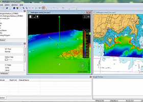 [ Zoom screenshot ] |
|
| Software Info | |
|
Best Vista Download periodically updates pricing and software information of CARIS Easy View full version from the publisher,
but some information may be out-of-date. You should confirm all information. Software piracy is theft, using crack, warez passwords, patches, serial numbers, registration codes, key generator, keymaker or keygen for CARIS Easy View license key is illegal and prevent future development of CARIS Easy View. Download links are directly from our mirrors or publisher's website, CARIS Easy View torrent files or shared files from rapidshare, yousendit or megaupload are not allowed! |
|
| Released: | August 27, 2015 |
| Filesize: | 106.00 MB |
| Platform: | Windows XP, Windows Vista, Windows Vista x64, Windows 7, Windows 7 x64, Windows 8, Windows 8 x64, Windows 10, Windows 10 x64 |
| Install | Instal And Uninstall |
| Add Your Review or Windows Vista Compatibility Report |
CARIS Easy View- Releases History |
| Software: | CARIS Easy View 4.2.13 |
| Date Released: | Aug 27, 2015 |
| Status: | New Release |
| Release Notes: | Consistent user experience in 2D and 3D The properties for coverages have been redesigned and apply both in 2D and 3D. A number of new options are presented including the ability to drape high resolution imagery (e.g. backscatter) over elevations in both 2D and 3D views. Also, a new user interface is provided to investigate the processing lineage of a dataset recorded in the metadata. Click to return to top of page Coordinate reference system enhancements The coordinate reference system (CRS) functionality has been augmented with EPSG CRS and transformations, such as NTv2. The user interface was upgraded with a new look and with additional capabilities. Users can now build a favourites list, see a list of recently used CRS entries, search for new entries and investigate all aspects of the selected reference system or transformation. Note that if an incorrect CRS has been selected when opening a dataset in the application, it is now possible to change the CRS in the Properties window wh |
| Software: | CARIS Easy View 4.1.11 |
| Date Released: | Aug 27, 2015 |
| Status: | New Release |
| Release Notes: | Expanded support for commonly used geospatial data formats (e.g. BAG, GeoTIFF, S-57) and web services (WMS, WCS, WMTS, WTMS). Upgraded support for non-proprietary BAG format to version 1.5.2, which is the latest version provided by the Open Navigation Surface Working Group. |
Most popular spatial in CAD downloads for Vista |
|
MITCalc Shafts Calculation 1.24 download by MITCalc
... coefficients of stress concentration. - Simple definition of spatial shaft load. - Calculation of reactions, courses of forces, moments, stress, deflection and bending angle of the shaft and others. - ...
type: Shareware ($24.00)
View Details
Download
categories: Shaft, shafts, design, strength check, stress concentration, critical speed, safety coefficients, deflection, bending angle, DIN 743, CAD, DXF, CAM |
 |
|
TNTatlas 2024 B20240606 download by MicroImages, Inc.
... primary concern in your professional life, or such spatial information may be a growing secondary responsibility. Your duties may include making spatial information available to a wide audience in an ... that lets you organize, distribute, and present the spatial information in your world in an easy, atlas-like ...
type: Freeware
View Details
Download
categories: geospatial viewer, view atlas, visualize geospatial data, atlas, map, viewer |
 |
|
VideoCAD Professional 14.0 download by CCTVCAD Software
... taken into account. Visualize by colors and hatch spatial resolution (pixel density) and field-of-view size of each camera on the site plan. Calculate and simulate in 3D the Depth of ...
type: Demo ($56.00)
View Details
Download
categories: CCTV design software, 3D CCTV, video surveillance design, focal length calculator, scene illumination, frame rate, field of view, depth of field, IP camera, megapixel, camera resolution, camera sensitivity, IR illuminator, CCTV AutoCAD |
 |
|
CARIS Easy View 4.2.13 download by CARIS
... a simple application that enables you to view spatial data imported from numerous types of files. It ... their order and adjust object parameters. View your spatial data using the free CARIS viewer. CARIS Easy ...
View Details
Download
|
 |
|
UCL Depthmap 0.8.0 download by University College London
... single software platform to perform a set of spatial network analyses designed to understand social processes within the built environment. It works at a variety of scales from building through ...
type: Open Source
View Details
Download
categories: urban environment, urban map, spatial network analysis, environment, map, analysis |
 |
|
p3d 2.6.2 download by Christer Sandin
... implemented for 5 instrument setups that use square-shaped spatial elements: PMAS/Larr, Spiral, VIMOS, FLAMES/Argus, and MPFS). Convert ... implemented for 6 instrument setups that use square-shaped spatial elements: PMAS/Larr, Spiral, VIMOS, FLAMES, MPFS, and ERA2) ...
type: Freeware
View Details
Download
categories: field spectrograph, data reduction, astronomical data, reduction, reduce, spectrograph |
 |
|
TNTmips 20240404 download by MicroImages, Inc.
... JPEG2000, PNG, MrSID, ECW, shapefile, File Geodatabase, Oracle Spatial, DGN, TAB, DXF, DWG ... Full-featured GIS that integrates imagery along with geometric data including vector, CAD, shape, pinmap, and ...
type: Freeware
View Details
Download
categories: GIS data analysis, analyze geodetic data, edit GIS dataset, GIS, dataset, editor, analysis |
 |
|
QGIS 3.36.1 download by Gary Sherman
... on your computer. QGIS supports many common spatial data formats (e.g. ESRI ShapeFile, geotiff). QGIS supports ... key features of "QGIS": · Support for spatially enabled PostgreSQL tables using PostGIS · Support for ...
type: Open Source
View Details
Download
categories: geographic information system, map creator, map viewer, GIS, geographic information, create, QGIS |
 |
|
Amira 2019.2 download by Visage Imaging, Inc.
... Vector fields · Tensors · Filament tracing · Spatial grids · Molecular visualization Analyze: · Measurement tools · Tissue statistics · Co-localization analysis · Arithmetic operations · Densitometry · ...
type: Trialware
View Details
Download
categories: 3D visualization platform, medical data viewer, Life Science visualizer, 3D visualization, Life Science, medical data |
 |
|
VideoCAD Starter 7.0 download by CCTVCAD Software
... plan. Display by separate colors different regions of spatial resolution and field-of-view size. Choose visually a relative location of cameras using the graphics window with CAD interface. Locate cameras on ...
type: Demo ($85.00)
View Details
Download
categories: CCTV design, CCTV system, video surveillance, camera, lens, focal length, field of view, IP camera, megapixel, camera resolution, lens calculator, cctv calculator, field of view calculator, camera calculator, 3D CCTV |
 |