Related Keywords
software gps downloadsgps software downloads
gps map software downloads
gps mapping software downloads
gps development software downloads
gps tracking software downloads
gps downloads
gps clock downloads
gps decoder downloads
gps nmea sentence downloads
gps toolkit downloads
gps serial port component downloads
gps c downloads
gps component vb downloads
gps component c downloads
gps navigation downloads
gps receivers downloads
gps express downloads
gps harta downloads
gps source code module downloads
Top Software Keywords
autocad downloads3d cad downloads
cad downloads
drawing downloads
import downloads
design downloads
dwg downloads
pdf to dwg downloads
dxf downloads
convert downloads
convert pdf to dwg downloads
dwg to pdf downloads
dxf to pdf downloads
converter downloads
pdf to dxf downloads
dwf to dwg downloads
dwg converter downloads
dwg to jpg downloads
dwg to dxf downloads
dwg to bmp downloads
stl downloads
dxf to pcl downloads
dwg to tiff downloads
intellicad downloads
pdf to cad downloads
dwg to gif downloads
convert dwg to pdf downloads
dwg to png downloads
dwg to dwf downloads
dxf to ps downloads
Vista Download
Vista downloadVista antivirus download
Vista wallpaper download
Vista wallpapers download
Vista themes download
Vista pack download
Vista ultimate download
Vista home download
Vista basic download
Vista business download
Vista x64 download
Vista transformation download
Vista transformation pack download
Vista boot download
Vista dvd download
Vista sidebar download
Vista aero download
Vista product key download
Downloads RSS
Top Downloads
Top Rated
Navigation: Home
\ Graphic Apps
\ CAD \ Engauge Digitizer for Windows
Engauge Digitizer for Windows12.0 by Mark Mitchell |

|
Software Description:
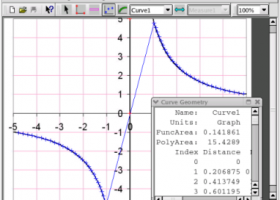
Engauge Digitizer - Digitizing softwareThis open source, digitizing software converts an image file showing a graph or map, into numbers. The image file can come from a scanner, digital camera or screenshot. The numbers can be read on the screen, and written or copied to a spreadsheet. The process starts with an image file containing a graph or map. The final result is digitized ...
type: Open Source
Download Engauge Digitizer for Windowscategories: digitize image, image to number, process image, digitize, convert, digitizer Add to Download Basket Report virus or spyware |
 [ Zoom screenshot ] |
|
| Software Info | |
|
Best Vista Download periodically updates pricing and software information of Engauge Digitizer for Windows full version from the publisher,
but some information may be out-of-date. You should confirm all information. Software piracy is theft, using crack, warez passwords, patches, serial numbers, registration codes, key generator, keymaker or keygen for Engauge Digitizer for Windows license key is illegal and prevent future development of Engauge Digitizer for Windows. Download links are directly from our mirrors or publisher's website, Engauge Digitizer for Windows torrent files or shared files from rapidshare, yousendit or megaupload are not allowed! |
|
| Released: | August 19, 2019 |
| Filesize: | 10.60 MB |
| Platform: | Windows 2000, Windows 2003, Windows XP, Windows Vista, Windows Vista x64 |
| Install | Instal And Uninstall |
| Add Your Review or Windows Vista Compatibility Report |
Engauge Digitizer for Windows- Releases History |
| Software: | Engauge Digitizer for Windows 12.0 |
| Date Released: | Aug 19, 2019 |
| Status: | New Release |
| Software: | Engauge Digitizer for Windows 10.4 |
| Date Released: | Oct 11, 2017 |
| Status: | New Release |
| Release Notes: | Show warning message when grid line maximum is exceed (#244) CSV export files have double quotes on fields with internal commas (#243) Status bar shows all of text for right-to-left languages (#240) |
| Software: | Engauge Digitizer for Windows 5.1 |
| Date Released: | Dec 24, 2012 |
| Status: | New Release |
| Release Notes: | Fix for broken point matching, and control of the x/theta axis label. |
Most popular software gps in CAD downloads for Vista |
|
Mobile Atlas Creator 2.2.1 download by Fredrik Moller
... source (GPL) program which creates offline atlases for GPS handhelds and cell phone applications like TrekBuddy, AndNav ... a large number of different (mobile) applications and GPS handhelds: AFTrack (Symbian) AlpineQuest (Android) AndNav (Android) BackCountry ...
View Details
Download
|
 |
|
ExpertGPS 8.64 download by TopoGrafix
ExpertGPS is the ultimate mapping software for Garmin, Magellan, and Lowrance GPS owners. ExpertGPS displays your waypoints, routes, and tracks ... database, and transfer your trip directly to your GPS in one click. ExpertGPS is a software ...
View Details
Download
|
 |
|
Engauge Digitizer for Windows 12.0 download by Mark Mitchell
Engauge Digitizer - Digitizing software This open source, digitizing software converts an image file showing a graph or ... but you do not have an odometer or GPS unit. However, you do have a map. ...
type: Open Source
View Details
Download
categories: digitize image, image to number, process image, digitize, convert, digitizer |
 |
|
TNTmips 20240404 download by MicroImages, Inc.
TNTmips software is a complete Geographic Information System (GIS) that ... reference image; place control points with coordinates from GPS devices ... Import and export an unsurpassed number of raster, ...
type: Freeware
View Details
Download
categories: GIS data analysis, analyze geodetic data, edit GIS dataset, GIS, dataset, editor, analysis |
 |
|
SierraSoft Land 4.0 download by SierraSoft S.r.l.
SierraSoft Land is a BIM software for land survey restitution and analysis. With SierraSoft ... various types of tools, such as total stations, GPS, laser scanners or drones. The entire flow of ...
View Details
Download
|
 |
|
NemaStudio 1.36.6465.25714 download by Sailsoft
... of various nautical instruments and target objects including GPS, AIS and Radar. All instruments, targets and ports ... different ports simultaneously. This makes this navigation simulation software program also very suitable for e.g. ECDIS training ...
type: Demo ($364.89)
View Details
Download
categories: nautical navigation, simulate nautical, navigation simulator, simulate, simulator, nautical |
 |
|
Elshayal Smart 23.02 download by Elshayal Smart Web On Line Software
Elshayal Smart is the first Arabian GIS software that is completely developed by Arabian developers team and independent of any commercial software package. Download Maps from Google Earth, and Trace & save GPS route and View and Rectify Raster Images gif, ...
View Details
Download
|
 |
|
QGIS 3.36.1 download by Gary Sherman
... proud to be itself Free and Open Source Software (FOSS). QGIS supports vector, raster, and database ... to do things like display tracks from your GPS. QGIS aims to be an easy to ...
type: Open Source
View Details
Download
categories: geographic information system, map creator, map viewer, GIS, geographic information, create, QGIS |
 |