Related Keywords
single file system downloadssingle file database downloads
single file downloads
file system downloads
file system repair downloads
file system utilities downloads
file system drivers xp downloads
file system info downloads
file system encryption downloads
file system monitor downloads
file system recovery downloads
file system permissions downloads
file system audit downloads
file system damage downloads
file system searcher downloads
file system permission downloads
file system to sharepoint downloads
file system migration tool downloads
file system migration downloads
file system migration utility downloads
Top Software Keywords
autocad downloads3d cad downloads
cad downloads
drawing downloads
import downloads
design downloads
dwg downloads
pdf to dwg downloads
dxf downloads
convert downloads
convert pdf to dwg downloads
dwg to pdf downloads
dxf to pdf downloads
converter downloads
pdf to dxf downloads
dwf to dwg downloads
dwg to dxf downloads
dwg converter downloads
dwg to jpg downloads
dwg to bmp downloads
stl downloads
dxf to pcl downloads
dwg to tiff downloads
intellicad downloads
pdf to cad downloads
dwg to gif downloads
convert dwg to pdf downloads
dwg to png downloads
dwg to dwf downloads
dxf to ps downloads
Vista Download
Vista downloadVista antivirus download
Vista wallpaper download
Vista wallpapers download
Vista themes download
Vista pack download
Vista ultimate download
Vista home download
Vista basic download
Vista business download
Vista x64 download
Vista transformation download
Vista transformation pack download
Vista boot download
Vista dvd download
Vista sidebar download
Vista aero download
Vista product key download
Downloads RSS
Top Downloads
Top Rated
Navigation: Home
\ Graphic Apps
\ CAD \ TNTmips
TNTmips20240404 by MicroImages, Inc. |

|
Software Description:
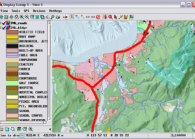
TNTmips is a geospatial image processing tool that allows you to analyze and modify GIS images. It is a professional application that can handle desktop cartography, electronic atlas preparation and spatial database management. ...
type: Freeware
Download TNTmipscategories: GIS data analysis, analyze geodetic data, edit GIS dataset, GIS, dataset, editor, analysis Add to Download Basket Report virus or spyware |
 [ Zoom screenshot ] |
|
| Software Info | |
|
Best Vista Download periodically updates pricing and software information of TNTmips full version from the publisher,
but some information may be out-of-date. You should confirm all information. Software piracy is theft, using crack, warez passwords, patches, serial numbers, registration codes, key generator, keymaker or keygen for TNTmips license key is illegal and prevent future development of TNTmips. Download links are directly from our mirrors or publisher's website, TNTmips torrent files or shared files from rapidshare, yousendit or megaupload are not allowed! |
|
| Released: | April 04, 2024 |
| Filesize: | 121.00 MB |
| Platform: | Windows XP, Windows Vista, Windows Vista x64, Windows 7, Windows 7 x64, Windows 8, Windows 8 x64, Windows 10, Windows 10 x64, Windows 11 |
| Install | Instal And Uninstall |
| Add Your Review or Windows Vista Compatibility Report |
TNTmips- Releases History |
| Software: | TNTmips 20240404 |
| Date Released: | Apr 4, 2024 |
| Status: | New Release |
| Software: | TNTmips 20240131 |
| Date Released: | Jan 31, 2024 |
| Status: | New Release |
| Software: | TNTmips 20240108 |
| Date Released: | Jan 8, 2024 |
| Status: | New Release |
Most popular single file system in CAD downloads for Vista |
|
RISAFoundation 13.0.4 download by RISA Technologies, LLC.
... to solve and optimize all types of foundation systems, including mat foundations, grade beams, pile caps, retaining ... for the drawing, design and optimization of foundation systems. Automatic mesh generation, thick plate modeling and ...
type: Demo ($1 050.00)
View Details
Download
categories: optimize foundation design, foundation analysis, analyze foundation, foundation, design, analyze |
 |
|
185Graph 4.2I download by RECKON IT, INC.
... elevation and/or hose streams. 185Graph has compact, single form modular design with all data input and ... on the same form. Instantly determine a sprinkler system's weakness by inspecting the detailed pressure loss data, ...
type: Trialware ($249.95)
View Details
Download
categories: grid calculator, hydraulic calculator, density cdalculator, calculator, hydraulic, sprinkler |
 |
|
Open3DALIGN 2.28 download by Paolo Tosco
... standard input. If PyMOL is installed on the system while Open3DALIGN is being operated interactively, the setup ... 1. A dataset is imported as SDF file 2. Optionally, for each compound of the dataset ...
type: Freeware
View Details
Download
categories: molecular alignment, molecular dynamics, dataset compound, molecule, alignment, compund |
 |
|
Open3DALIGN x64 2.28 download by Paolo Tosco
... standard input. If PyMOL is installed on the system while Open3DALIGN is being operated interactively, the setup ... 1. A dataset is imported as SDF file 2. Optionally, for each compound of the dataset ...
type: Freeware
View Details
Download
categories: x64 molecular alignment, x64 molecular dynamics, x64 dataset compound, x64 molecule, x64 alignment, x64 compund |
 |
|
TNTmips 20240404 download by MicroImages, Inc.
TNTmips software is a complete Geographic Information System (GIS) that lets you work with virtually any ... data. TNTmips provides professional geospatial tools in a single package at an affordable price without costly add-ons. ...
type: Freeware
View Details
Download
categories: GIS data analysis, analyze geodetic data, edit GIS dataset, GIS, dataset, editor, analysis |
 |
|
Pulsonix 11.0 download by WestDev Ltd.
... creation features, all design checking routines and manufacturing file export to get your designs from concept to ... needs grow. Node locked gives you a single system whereas the floating license option gives you ...
type: Trialware
View Details
Download
categories: PCB creator, design circuit board, PCB schematic capture, circuit board, create, design |
 |
|
QGIS 3.36.1 download by Gary Sherman
... formats support by the OGR library · MapInfo files · GRASS integration, including view, edit, and analysis ... and multiband RGB) · Export to Mapserver map file · Digitizing support · Map overview · Plugins ...
type: Open Source
View Details
Download
categories: geographic information system, map creator, map viewer, GIS, geographic information, create, QGIS |
 |