Related Keywords
raster to vector downloadsraster to vector software downloads
raster to vector conversion downloads
raster to vector converter sdk downloads
raster to vector sdk downloads
raster to vector convert downloads
raster to vector converter downloads
convert raster to vector downloads
raster to ps downloads
raster to emf downloads
image to vector downloads
pdf to vector downloads
bitmap to vector downloads
gif to vector downloads
jpg to vector downloads
pbm to vector downloads
xps to vector downloads
scan to vector downloads
ttf to vector downloads
truetype to vector downloads
Top Software Keywords
autocad downloadscad downloads
3d cad downloads
drawing downloads
import downloads
design downloads
dwg downloads
pdf to dwg downloads
dxf downloads
convert downloads
convert pdf to dwg downloads
dwg to pdf downloads
dxf to pdf downloads
converter downloads
pdf to dxf downloads
dwf to dwg downloads
dwg to dxf downloads
dwg converter downloads
dwg to jpg downloads
dwg to bmp downloads
stl downloads
dxf to pcl downloads
dwg to tiff downloads
intellicad downloads
pdf to cad downloads
dwg to gif downloads
convert dwg to pdf downloads
dwg to png downloads
dwg to dwf downloads
dxf to ps downloads
Vista Download
Vista downloadVista antivirus download
Vista wallpaper download
Vista wallpapers download
Vista themes download
Vista pack download
Vista ultimate download
Vista home download
Vista basic download
Vista business download
Vista x64 download
Vista transformation download
Vista transformation pack download
Vista boot download
Vista dvd download
Vista sidebar download
Vista aero download
Vista product key download
Downloads RSS
Top Downloads
Top Rated
Navigation: Home
\ Graphic Apps
\ CAD \ CARIS Easy View
CARIS Easy View4.2.13 by CARIS |

|
Software Description:
The program can render the loaded spatial data in a three-dimensional mode, allowing you to view your project from any angle. It is even possible to record videos of your fly-throughs and save them to AVI files. ...
Download CARIS Easy ViewAdd to Download Basket Report virus or spyware |
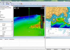 [ Zoom screenshot ] |
|
| Software Info | |
|
Best Vista Download periodically updates pricing and software information of CARIS Easy View full version from the publisher,
but some information may be out-of-date. You should confirm all information. Software piracy is theft, using crack, warez passwords, patches, serial numbers, registration codes, key generator, keymaker or keygen for CARIS Easy View license key is illegal and prevent future development of CARIS Easy View. Download links are directly from our mirrors or publisher's website, CARIS Easy View torrent files or shared files from rapidshare, yousendit or megaupload are not allowed! |
|
| Released: | August 27, 2015 |
| Filesize: | 106.00 MB |
| Platform: | Windows XP, Windows Vista, Windows Vista x64, Windows 7, Windows 7 x64, Windows 8, Windows 8 x64, Windows 10, Windows 10 x64 |
| Install | Instal And Uninstall |
| Add Your Review or Windows Vista Compatibility Report |
CARIS Easy View- Releases History |
| Software: | CARIS Easy View 4.2.13 |
| Date Released: | Aug 27, 2015 |
| Status: | New Release |
| Release Notes: | Consistent user experience in 2D and 3D The properties for coverages have been redesigned and apply both in 2D and 3D. A number of new options are presented including the ability to drape high resolution imagery (e.g. backscatter) over elevations in both 2D and 3D views. Also, a new user interface is provided to investigate the processing lineage of a dataset recorded in the metadata. Click to return to top of page Coordinate reference system enhancements The coordinate reference system (CRS) functionality has been augmented with EPSG CRS and transformations, such as NTv2. The user interface was upgraded with a new look and with additional capabilities. Users can now build a favourites list, see a list of recently used CRS entries, search for new entries and investigate all aspects of the selected reference system or transformation. Note that if an incorrect CRS has been selected when opening a dataset in the application, it is now possible to change the CRS in the Properties window wh |
| Software: | CARIS Easy View 4.1.11 |
| Date Released: | Aug 27, 2015 |
| Status: | New Release |
| Release Notes: | Expanded support for commonly used geospatial data formats (e.g. BAG, GeoTIFF, S-57) and web services (WMS, WCS, WMTS, WTMS). Upgraded support for non-proprietary BAG format to version 1.5.2, which is the latest version provided by the Open Navigation Surface Working Group. |
Most popular raster to vector in CAD downloads for Vista |
|
R2V 3.66 download by MR Soft
R2V is a tool for converting raster images to vector by drawing centerlines and outlines. R2V converts architect, ... various technical drawings, maps and other types from raster to vector format. A vector format can be ...
type: Shareware ($42.00)
View Details
Download
categories: vector, r2v, vectorize, cnc, photo, engraving, bmp, hobby, carving, mill, cad, cam, stl, image, hpgl, dxf, raster, grayscale, conversion, g-code |
 |
|
Thuban for Windows 1.2.2 download by Thuban Development Team
... Data Viewer with the following features: # Vector Data Support: Shapefile, PostGIS Layer and OGR # Raster Data Support: GeoTIFF Layer and GDAL # Comfortable ... and Joins # Projection Support # Printing and Vector Export # API for Add-Ons (Extensions) # Multi-Language ...
type: Open Source
View Details
Download
categories: geographic data viewer, gis viewer, analyze geographic information, information, geographic, viewer |
 |
|
jHepWork 3.9 download by Dr. Sergei Chekanov
... function visualization. All plots can be exported to raster formats (PDF, PNG, JPG, etc.) and high-quality vector formats (PostScript, EPS) ready to be included into ...
type: Freeware
View Details
Download
categories: data-analysis framework, data manipulation, data plotting, analyze, analysis, analyzer |
 |
|
RhinoART 1.0.0.0 download by MecSoft Corporation
... new modeling techniques for modeling artistic shapes using raster bitmap images. Used in conjunction with Rhino's 3D modeling tools, it offers a complementary set of modeling techniques for jewelry design, ...
type: Demo
View Details
Download
categories: Rhinoceros plug-in, create relief shape, vector curve creator, create, creator, shape |
 |
|
BabaCAD 2.0.0 download by Mirza Coralic
... layers and blocks Draw and modify 2D vector objects like point, line, rectangle, polyline with arc ... (jpg, bmp, gif,...) Insert and manage georeferenced raster images (tif/tfw,jpg/jgw,bmp/bpw) Fast OpenGL graphics used for ...
View Details
Download
|
 |
|
SCaVis 2.3 download by Dr. Sergei Chekanov
... function visualization. All plots can be exported to raster formats (PDF, PNG, JPG, etc.) and high-quality vector formats (PostScript, EPS) ready to be included into ...
type: Freeware
View Details
Download
categories: data-analysis framework, data manipulation, data plotting, analyze, analysis, analyzer |
 |
|
TNTmips 20240404 download by MicroImages, Inc.
... Import and export an unsurpassed number of raster, geometric, and database file formats; convert between data ... that integrates imagery along with geometric data including vector, CAD, shape, pinmap, and TIN formats. Maintain relational ...
type: Freeware
View Details
Download
categories: GIS data analysis, analyze geodetic data, edit GIS dataset, GIS, dataset, editor, analysis |
 |
|
CARIS Easy View 4.2.13 download by CARIS
... control of the data. Users can load multiple raster, point cloud and vector data sources, change the order in which they ... wide range file types, enabling you to analyze raster and vector data saved to numerous formats. CARIS ...
View Details
Download
|
 |
|
QGIS 3.36.1 download by Gary Sherman
... and Open Source Software (FOSS). QGIS supports vector, raster, and database formats and lets you browse and ... data viewing needs. QGIS supports a number of raster and vector data formats, with new support easily ...
type: Open Source
View Details
Download
categories: geographic information system, map creator, map viewer, GIS, geographic information, create, QGIS |
 |
|
CST CAD Navigator 1 download by CADSoftTools
... section views. SUPPORTED FORMATS: CAD formats: DWG, DXF; Vector formats: PDF, SVG, CGM, GBR, PLT, HPGL, HGL, ... SLDPRT, SAT, FSAT, SAB, OBJ, BREP, SMT, IPT; Raster formats: PNG, BMP, JPG, JPEG, TIF, TIFF, GIF. ...
type: Shareware ($79.00)
View Details
Download
categories: CAD, CAD software, CAD viewer, 3D viewer, DWG, DXF, STEP, IGES, STL, SLDPRT, X_T, X_B, measuring tools, CAD converter, DWG viewer, STEP viewer, IGES viewer, SLDPRT viewer, X_T viewer |
 |