Related Keywords
point to surface downloadspoint to point tunneling downloads
point to point communication downloads
dvd to surface tab downloads
dvd to surface tablet downloads
power point to dvd downloads
power point to video downloads
power point to mpeg downloads
power point to avi downloads
power point to mp4 downloads
power point to wmv downloads
power point to pdf downloads
power point to pdf creator downloads
power point to flash converter downloads
convert power point to pdf downloads
surface downloads
surface test downloads
surface scan downloads
surface mesh downloads
surface fitting downloads
Top Software Keywords
autocad downloads3d cad downloads
cad downloads
drawing downloads
import downloads
design downloads
dwg downloads
pdf to dwg downloads
dxf downloads
convert downloads
convert pdf to dwg downloads
dwg to pdf downloads
dxf to pdf downloads
converter downloads
pdf to dxf downloads
dwf to dwg downloads
dwg to dxf downloads
dwg converter downloads
dwg to jpg downloads
dwg to bmp downloads
stl downloads
dxf to pcl downloads
dwg to tiff downloads
intellicad downloads
pdf to cad downloads
dwg to gif downloads
convert dwg to pdf downloads
dwg to png downloads
dwg to dwf downloads
dxf to ps downloads
Vista Download
Vista downloadVista antivirus download
Vista wallpaper download
Vista wallpapers download
Vista themes download
Vista pack download
Vista ultimate download
Vista home download
Vista basic download
Vista business download
Vista x64 download
Vista transformation download
Vista transformation pack download
Vista boot download
Vista dvd download
Vista sidebar download
Vista aero download
Vista product key download
Downloads RSS
Top Downloads
Top Rated
Navigation: Home
\ Graphic Apps
\ CAD \ CARIS Easy View
CARIS Easy View4.2.13 by CARIS |

|
Software Description:
The program can render the loaded spatial data in a three-dimensional mode, allowing you to view your project from any angle. It is even possible to record videos of your fly-throughs and save them to AVI files. ...
Download CARIS Easy ViewAdd to Download Basket Report virus or spyware |
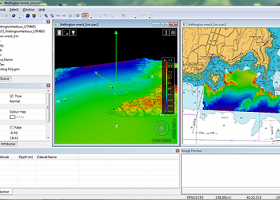 [ Zoom screenshot ] |
|
| Software Info | |
|
Best Vista Download periodically updates pricing and software information of CARIS Easy View full version from the publisher,
but some information may be out-of-date. You should confirm all information. Software piracy is theft, using crack, warez passwords, patches, serial numbers, registration codes, key generator, keymaker or keygen for CARIS Easy View license key is illegal and prevent future development of CARIS Easy View. Download links are directly from our mirrors or publisher's website, CARIS Easy View torrent files or shared files from rapidshare, yousendit or megaupload are not allowed! |
|
| Released: | August 27, 2015 |
| Filesize: | 106.00 MB |
| Platform: | Windows XP, Windows Vista, Windows Vista x64, Windows 7, Windows 7 x64, Windows 8, Windows 8 x64, Windows 10, Windows 10 x64 |
| Install | Instal And Uninstall |
| Add Your Review or Windows Vista Compatibility Report |
CARIS Easy View- Releases History |
| Software: | CARIS Easy View 4.2.13 |
| Date Released: | Aug 27, 2015 |
| Status: | New Release |
| Release Notes: | Consistent user experience in 2D and 3D The properties for coverages have been redesigned and apply both in 2D and 3D. A number of new options are presented including the ability to drape high resolution imagery (e.g. backscatter) over elevations in both 2D and 3D views. Also, a new user interface is provided to investigate the processing lineage of a dataset recorded in the metadata. Click to return to top of page Coordinate reference system enhancements The coordinate reference system (CRS) functionality has been augmented with EPSG CRS and transformations, such as NTv2. The user interface was upgraded with a new look and with additional capabilities. Users can now build a favourites list, see a list of recently used CRS entries, search for new entries and investigate all aspects of the selected reference system or transformation. Note that if an incorrect CRS has been selected when opening a dataset in the application, it is now possible to change the CRS in the Properties window wh |
| Software: | CARIS Easy View 4.1.11 |
| Date Released: | Aug 27, 2015 |
| Status: | New Release |
| Release Notes: | Expanded support for commonly used geospatial data formats (e.g. BAG, GeoTIFF, S-57) and web services (WMS, WCS, WMTS, WTMS). Upgraded support for non-proprietary BAG format to version 1.5.2, which is the latest version provided by the Open Navigation Surface Working Group. |
Most popular point to surface in CAD downloads for Vista |
|
RhinoResurf2(WIP) for Rhino 4.0 download by RESURF
... ability to reconstruct the geometry represented by NURB surface of an object from a mesh or point cloud which describes it.esh model to NURBS surface. Features: NURBS fitting with specified tolerance. ...
type: Shareware ($397.00)
View Details
Download
categories: Rhino plug-in, rebuild NURBS surface, NURBS surface rebuilder, Rhino, plug-in, NURBS |
 for Rhino") |
|
TopoLT 15.2 download by CADWARE Engineering
... cadastre projects. FEATURES: · draws directly points from coordinate files, draws coordinates from total station ... coordinates from drawing directly to total station; · point labels can be optimized so that there would ...
type: Trialware ($600.00)
View Details
Download
categories: topographical plan, cadastral plan, terrain model, topography, cadaster, terrain |
 |
|
Gwyddion 2.66 download by David Necas and Petr Klapetek
... kernel · statistical functions: Ra, RMS, projected and surface area, inclination, histograms, 1D and 2D correlation functions, PSDF, 1D and 2D angular distributions, Minkowski functionals, facet orientation analysis · statistical ...
type: Open Source
View Details
Download
categories: data visualization, data analysis, height field analysis, analyze, visualize, visualizer |
 |
|
Multiwfn 3.7 download by sobereva
... etc.). · Outputting all supported properties at a point. · Outputting properties in a line and plotting ... and can be viewed in terms of iso surface. Setting up grid is very flexible and convenient. ...
type: Open Source
View Details
Download
categories: wavefunction analysis, topology analysis, molecular structure, analysis, analize, wavefunction |
 |
|
Maxsurf 17.07 download by Bentley Systems
... and appendages. An unlimited number of trimmed NURB surfaces can be used to model any vessel from ... with limited training time. Any number of NURB surfaces can be joined, trimmed and manipulated to create ...
View Details
Download
|
 |
|
FOIL Release 4.5 download by Vacanti Yacht Design LLC
... If a new keel requires the minimum wetted surface (reduce friction drag) which foil shape do you ... volume in a keel while keeping the wetted surface minimized. Design a foil with a high area ...
type: Demo ($199.00)
View Details
Download
categories: performance assessment, foil performance, assess hydrofoil, foil, hydrofoil, performance |
|
ProSurf 3.222 download by New Wave Systems, Inc.
... program deals with relational trimmed NURB curve and surface 3D modeling. The program is customized for the ... FEATURES: · Full trimmed NURB curve and surface 3D modeling · Point, line, polyline, NURB curve ...
type: Trialware ($395.00)
View Details
Download
categories: create ship model, boat designer, NURB curve, create, design, designer |
|
|
GOM Inspect 7.5 SR1 download by GOM
... mesh processing software for dimensional analysis of 3D point clouds and viewer for ATOS and GOM Inspect ... GOM Inspect include CAD Data and 3D Point Cloud Import 3D Mesh Processing 3D Inspection Tools ...
View Details
Download
|
 |
|
TriSpace 2021.24.3.652 download by GEOSTRU
... as it imposes no limits regarding either triangulation points nor on the number of sections. Further thanks ... Rock Fall. General features: Input of point coordinates from the keyboard, with the possibility to ...
type: Trialware ($500.00)
View Details
Download
categories: Terrain Calculation, 3D Terrain Viewer, View 3D Surface, Calculation, Terrain, Surface |
 |
|
GetNexrad 4.4.2 download by Carson
... radar rainfall loops and to generate the basin point file (NexradPointESX10210.txt) used by GetRealtime.exe for computing the ... and graphical storm tracking. Storm ETA at any point of interest. Alarms! for Weather Service issued warnings. ...
type: Freeware
View Details
Download
categories: extract rainfall amount, DBZ analysis, view radar rainfall, view, extract, rainfall |
 |