Related Keywords
perform downloadsperform morphing downloads
perform calculation downloads
perform stretch downloads
perform admin tasks downloads
perform meta analysis downloads
perform prp test downloads
perform stochastic simulation downloads
perform computation downloads
allows to perform downloads
person or perform downloads
improve system perform downloads
Top Software Keywords
autocad downloads3d cad downloads
cad downloads
drawing downloads
import downloads
design downloads
dwg downloads
pdf to dwg downloads
convert pdf to dwg downloads
dxf downloads
convert downloads
dxf to pdf downloads
dwg to pdf downloads
converter downloads
pdf to dxf downloads
dwf to dwg downloads
dwg converter downloads
dwg to jpg downloads
dwg to dxf downloads
dwg to bmp downloads
stl downloads
dxf to pcl downloads
dwg to tiff downloads
intellicad downloads
pdf to cad downloads
dwg to gif downloads
convert dwg to pdf downloads
dwg to png downloads
dwg to dwf downloads
dxf to ps downloads
Vista Download
Vista downloadVista antivirus download
Vista wallpaper download
Vista wallpapers download
Vista themes download
Vista pack download
Vista ultimate download
Vista home download
Vista basic download
Vista business download
Vista x64 download
Vista transformation download
Vista transformation pack download
Vista boot download
Vista dvd download
Vista sidebar download
Vista aero download
Vista product key download
Downloads RSS
Top Downloads
Top Rated
Navigation: Home
\ Graphic Apps
\ CAD \ MountainsMap Scanning Topography
MountainsMap Scanning Topography6.2.6266 by Digital Surf |

|
Software Description:
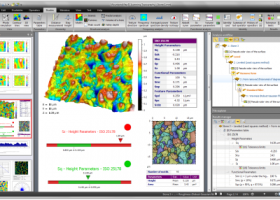
... Scanning Topography is a professional application designed to perform surface analysis for 3D surface profilometers. With MountainsMap Scanning Topography, users will be able to easily analyze measurements and metrology data. It features an extensive set of surface texture parameters. ...
type: Trialware
Download MountainsMap Scanning Topographycategories: surface profilometer, scanning opography, surface analysis, topography, profilometer, surface Add to Download Basket Report virus or spyware |
 [ Zoom screenshot ] |
|
| Software Info | |
|
Best Vista Download periodically updates pricing and software information of MountainsMap Scanning Topography full version from the publisher,
but some information may be out-of-date. You should confirm all information. Software piracy is theft, using crack, warez passwords, patches, serial numbers, registration codes, key generator, keymaker or keygen for MountainsMap Scanning Topography license key is illegal and prevent future development of MountainsMap Scanning Topography. Download links are directly from our mirrors or publisher's website, MountainsMap Scanning Topography torrent files or shared files from rapidshare, yousendit or megaupload are not allowed! |
|
| Released: | September 29, 2014 |
| Filesize: | 511.00 MB |
| Platform: | Windows XP, Windows Vista, Windows Vista x64, Windows 7, Windows 7 x64 |
| Install | Instal And Uninstall |
| Add Your Review or Windows Vista Compatibility Report |
MountainsMap Scanning Topography- Releases History |
| Software: | MountainsMap Scanning Topography 6.2.6266 |
| Date Released: | May 3, 2012 |
| Status: | New Release |
| Release Notes: | Surface partitioning with or without leveling: · A sub-surface can be extracted with or without leveling using the Partition Leveling operator. Contour Analysis/Advanced Contour Analysis module enhancements: · Horizontal contour extraction with smoothing - parametric profiles extracted on the XY plane can be smoothed automatically. Integration of Chinese GB/T standards: · The "right parameters wherever you are" feature has been extended to include Chinese GB/T standard references for parameter families, which can be selected in Metrological Preferences - References. Advanced Contour Analysis module enhancements: · Automatic association of geometric elements with profiles - line segments, arcs and circles (greater than a specified minimum size) can be automatically associated with profiles. This significantly speeds up the definition of nominal form (which is otherwise carried out interactively or by fitting CAD DXF data to the profile). |
Most popular perform in CAD downloads for Vista |
|
MagicPlot Pro 2.9.3 download by MagicPlot.com
... Fitting Enter equation, edit data range visually and perform a fit. MagicPlot was verified with NIST datasets for testing fitting algorithms. Smart Text Data Import Use ‘?Import Text Table’ ...
type: Trialware ($198.00)
View Details
Download
categories: Nonlinear Fitting, Create Plot, customizable plot, Plotter, Plot, fitter |
 |
|
SDMetrics 2.5 download by Jürgen Wüst
... or Smalltalk source code, .NET assemblies, etc., to perform design measurement on such sources. Data export: · Design measures unleash their full potential when they are subjected to powerful ...
type: Freeware
View Details
Download
categories: analyze structural property, design metrics, establish benchmark, analyzer, analyze, measurement |
 |
|
DirectMath x64 3.2.3 download by Joe Gregg
... to do, making it possible for you to perform a wide range of operations without having to learn a specialized programming language. In particular, DirectMath x64 makes it possible to ...
type: Freeware
View Details
Download
categories: x64 math calculation, x64 algebra calculation, x64 solve equation, x64 math, x64 algebra, x64 calculation |
 |
|
DynaFit 4.04.061 Beta download by BioKin, Ltd.
The DynaFit application was developed to perform nonlinear least-squares regression of chemical kinetic, enzyme kinetic, or ligand-receptor binding data. The experimental data can be either initial reaction velocities in dependence ...
type: Freeware
View Details
Download
categories: chemical kinetic, enzyme kinetic, chemical analysis, chemical, kinetic, enzyme |
 |
|
TopoLT 15.2 download by CADWARE Engineering
... available for functions that create 3D model and perform volumes calculation; · raster images can be transformed in order to achieve correlation with the coordinates system of the plan and ...
type: Trialware ($600.00)
View Details
Download
categories: topographical plan, cadastral plan, terrain model, topography, cadaster, terrain |
 |
|
Cain 1.10 download by Sean Mauch
Cain performs stochastic and deterministic simulations of chemical reactions. It can spawn multiple simulation processes to utilize multi-core computers. It stores models, simulation parameters, and simulation results in an XML ...
type: Open Source
View Details
Download
categories: chemical reaction simulation, simulate chemical reaction, perform stochastic simulation, simulate, simulation, analyze |
 |
|
Cytoscape 3.9.0 download by Cytoscape Consortium
... annotations Establish powerful visual mappings across these data Perform advanced analysis and modeling using Cytoscape plugins Visualize and analyze human-curated pathway datasets such as Reactome or KEGG. ...
type: Open Source
View Details
Download
categories: molecular interaction network, molecule visualization, bioinformatics viewer, visualization, molecule, Biology |
 |
|
MITCalc Slender strut buckling 1.20 download by MITCalc
... is designed to calculate the optimum cross-section and perform strength check of slender struts strained for buckling. The program includes: - Selection of six basic types of buckling. - Calculation ...
type: Shareware ($18.00)
View Details
Download
categories: buckling, slender strut, beam, column, moment, stress, safety, DIN 1025, 1026, 1028, 1029, cross-section, area characteristics, permitted stress, Johnson, Tetmajer, Euler, Secant |
 |
|
Mini CAD Viewer 3.6.0.0 download by zxt2007.com
... It carries "thumbnail" view, which allows users quickly perform search on task folders. It supports DWG, DWF, DXF formats. It allows drawing file to be printed. ...
View Details
Download
|
 |
|
TransLT 15.0 download by 3D Space
... aimed at specialists who use GPS technology to perform geodetic works. The program interface is intuitive, easy ... transformation parameters between two coordinates systems can be performed in the following situations: * 1D transformation ...
type: Trialware ($250.00)
View Details
Download
categories: calculate transformation parameter, coordinate transformation, transformation parameter, calculate, geodetic, GPS |
 |