Related Keywords
maps downloadsmaps flash downloads
maps in flash downloads
maps for website downloads
maps puzzle downloads
maps icon downloads
maps icons downloads
maps x64 downloads
maps downloader downloads
image maps downloads
interactive maps downloads
flash maps downloads
business maps downloads
mind maps downloads
concept maps downloads
3d mind maps downloads
interactive flash maps downloads
usa maps downloads
informative maps downloads
thematic maps downloads
Top Software Keywords
photoshop downloadsphoto editing downloads
picture downloads
images downloads
graphics downloads
image editing downloads
image editor downloads
photos downloads
image downloads
effects downloads
gif downloads
editor downloads
free photo editor downloads
resize downloads
photo editor downloads
graphic downloads
digital downloads
edit downloads
digital photography downloads
texture downloads
free photo editing software downloads
photo downloads
jpeg downloads
photo editing software downloads
digital photo downloads
photography downloads
bmp downloads
jpg downloads
watermark downloads
batch downloads
Vista Download
Vista downloadVista antivirus download
Vista wallpaper download
Vista wallpapers download
Vista themes download
Vista pack download
Vista ultimate download
Vista home download
Vista basic download
Vista business download
Vista x64 download
Vista transformation download
Vista transformation pack download
Vista boot download
Vista dvd download
Vista sidebar download
Vista aero download
Vista product key download
Downloads RSS
Featured Download

AKVIS Enhancer
Photo Enhancement
Software

PicaJet FX
Digital photo
management software
Top Downloads
Top Rated
Navigation: Home
\ Graphic Apps
\ Editors \ Vextractor
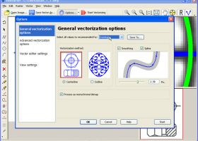
Vextractor7.20 by VextraSoft |

|
Software Description:
... Design software. You can also vectorize charts, drawings, maps and schemes for input to CAD or GIS systems. Supported vector formats: DXF, WMF, EMF, SVG, EPS, AI, Shape, MapInfo, ASCII XYZ. ...
type: Shareware ($99.95)
Download Vextractorcategories: raster to vector, image to vector, raster, vector, vectorise, vectorize, vectorization, vectorizing, trace, convert, conversion, r2v, scan, cad, autocad, dxf, tiff, gif, bmp.jpg, jpeg, polyline, centerline, outline, image, gis, digitize, digitizing Buy Now Add to Download Basket Report virus or spyware |
 [ Zoom screenshot ] |
|
| Software Info | |
|
Best Vista Download periodically updates pricing and software information of Vextractor full version from the publisher,
but some information may be out-of-date. You should confirm all information. Software piracy is theft, using crack, warez passwords, patches, serial numbers, registration codes, key generator, keymaker or keygen for Vextractor license key is illegal and prevent future development of Vextractor. Download links are directly from our mirrors or publisher's website, Vextractor torrent files or shared files from rapidshare, yousendit or megaupload are not allowed! |
|
| Website: | VextraSoft - Vextractor homepage |
| Released: | August 25, 2018 |
| Filesize: | 12.34 MB |
| Language: | English, French, German, Italian, Russian |
| Platform: | Windows XP, Windows Vista, Windows 7 x32, Windows 7 x64, Windows 2000, Windows 2003, Windows Vista, Windows Vista |
| Requirements: | Pentium III, 128 Mb RAM |
| Install | Install and Uninstall |
| Add Your Review or Windows Vista Compatibility Report |
Vextractor- Releases History |
| Software: | Vextractor 7.20 |
| Date Released: | Aug 25, 2018 |
| Status: | Major Update |
| Release Notes: | Arcs and circles recognition algorithm was speeded up. |
| Software: | Vextractor 7.10 |
| Date Released: | Apr 27, 2017 |
| Status: | Major Update |
| Release Notes: | Some interface improvements |
| Software: | Vextractor 6.92 |
| Date Released: | Sep 7, 2016 |
| Status: | Major Update |
| Release Notes: | Bugfix release:
1. Fixed bug with resolution in JPEG. 2. XYZ vector format: sequential numbering of items. |
Most popular maps in Editors downloads for Vista |
|
Vextractor 7.20 download by VextraSoft
... Design software. You can also vectorize charts, drawings, maps and schemes for input to CAD or GIS systems. Main features of Vextractor: Input raster formats: BMP, GIF, TIFF, GeoTIFF, JPEG, ...
type: Shareware ($99.95)
View Details
Download
categories: raster to vector, image to vector, raster, vector, vectorise, vectorize, vectorization, vectorizing, trace, convert, conversion, r2v, scan, cad, autocad, dxf, tiff, gif, bmp.jpg, jpeg, polyline, centerline, outline, image, gis, digitize, digitizing |
 |
|
3DFieldPro 4.6.7.0 download by Vladimir Galouchko
... and versatile software designed for creating three-dimensional surface maps and contour plots from a variety of data ... data into visually compelling 3D surfaces and contour maps. The software supports a wide range of input ...
type: Demo
View Details
Download
categories: geospatial tools, Vladimir Galouchko, Map Plotter, Data To Map, 3DFieldPro, Plotter, Plot, terrain analysis, data visualization, Mapper, Map Creator, mapping software, Create, 3DFieldPro free download, download 3DFieldPro |
 |
|
3DFieldPro x64 4.6.5 download by Vladimir Galouchko
... program. 3DFieldPro x64 converts your data into contour maps, surface or volume plots. 3DFieldPro x64 is an ... whose purpose is to help you create 2D/3D maps of contours (isolines) based on numerical data. In ...
type: Demo ($399.00)
View Details
Download
categories: x64 contour map, map creator x64, x64plot, x64map, data to plot x64, x64 create contour map, x64 surface plot, interpolation x64, x64 digitize image, x64 plotter, x64 map, x64 surface |
 |
|
Image Constructor 2.5 download by Image Tools Group
... original illustrations, structural schemas and diagrams, simple geographical maps and location plants in form of texts and small images over some background with picture or gradient fill and save them ...
type: Shareware ($25.00)
View Details
Download
categories: imageconstructor, image, constructor, create illustration, presentation, picture, geographical map, plan, graphics, webgraphics, flowchart, diagram, schema, image collection, GIF, publishing, homepage, imageediting, web, business, software, downloads |
 |
|
Panorama Express Professional 3.0 download by Imatronics
... virtual tour navigation controls * multiple synchronized interactive maps * multiple synchronized interactive compasses * multiple independent interactive maps * multiple hotspots of different kinds * multiple ...
type: Trialware ($99.00)
View Details
Download
categories: create tour, create interactive panorama, panoramic tours, creator, editor, viewer |
 |
|
PhotoLine 22.01 download by Computerinsel
... Export * Tile images, create buttons and image maps Many more * Batch conversion * Create slideshows * Record actions * Print multipage documents, flyers and labels * ...
View Details
Download
|
 |
|
HDR Expose 2.1.1 build 9804 download by Unified Color
... data in your HDR image and "dynamic range maps" it into a file that retains naturally clear highlights, vibrant mid-tones and beautifully open shadows. HDR Expose can do this ...
View Details
Download
|
|
X-Blender 2.79b [rev14] download by winPenPack
... blur, post-production effects, fields, non-square pixels · Environment maps, halos, lens flares, fog · Various surface shaders such as Lambert, Phong, Oren-nayar, Blinn, Toon · Edge rendering for toon shading ...
type: Open Source
View Details
Download
categories: 3D model, 3D animation, 3D render, animator, animation, animate, portable |
 |
|
Realtime Landscaping Plus 2013 8.14 download by Idea Spectrum, Inc.
... and movement path. Import your property with Google maps using our new wizard. Walk through your landscape designs in realtime 3D and create movies which you can upload to YouTube. ...
type: Demo ($79.95)
View Details
Download
categories: landscape, landscaping, design, garden, gardening, home, yard, backyard, deck, fence |
 |
|
Dr. Regener LandMap Vivo 10 download by GPSsur Dr. Erhard Regener
Create own true to scale maps, store online maps locally with Vivo techology, map editor, dataexchange with ...
type: Shareware ($65.00)
View Details
Download
categories: Map, geodata, wgs84, aereal photo, orthophoto, GPS, openstreetmap, google earth, virtual earth, roadmap, landmap, satellite, kml, kmz, onlinemaps, GPX |
 |