Related Keywords
maps downloadsmaps flash downloads
maps in flash downloads
maps for website downloads
maps puzzle downloads
maps icon downloads
maps icons downloads
maps x64 downloads
maps downloader downloads
image maps downloads
interactive maps downloads
flash maps downloads
business maps downloads
mind maps downloads
concept maps downloads
3d mind maps downloads
interactive flash maps downloads
usa maps downloads
informative maps downloads
thematic maps downloads
Top Software Keywords
photoshop downloadsphoto editing downloads
picture downloads
images downloads
graphics downloads
image editing downloads
photos downloads
image editor downloads
image downloads
effects downloads
gif downloads
editor downloads
photo editor downloads
resize downloads
free photo editor downloads
graphic downloads
digital downloads
edit downloads
texture downloads
digital photography downloads
free photo editing software downloads
jpeg downloads
photo editing software downloads
photo downloads
digital photo downloads
photography downloads
jpg downloads
bmp downloads
watermark downloads
batch downloads
Vista Download
Vista downloadVista antivirus download
Vista wallpaper download
Vista wallpapers download
Vista themes download
Vista pack download
Vista ultimate download
Vista home download
Vista basic download
Vista business download
Vista x64 download
Vista transformation download
Vista transformation pack download
Vista boot download
Vista dvd download
Vista sidebar download
Vista aero download
Vista product key download
Downloads RSS
Featured Download

AKVIS Enhancer
Photo Enhancement
Software

PicaJet FX
Digital photo
management software
Top Downloads
Top Rated
Navigation: Home
\ Graphic Apps
\ Editors \ PhotoLine
PhotoLine22.01 by Computerinsel |

|
Software Description:
PhotoLine is an imaging processing software, image browser, layout program, vector editor, batch converter and web editor with many functions. It is available as 32/64 bit application. The imaging functions fully supports Lab, CMYK, 16 bit per channel, ICC profiles and raw data of digital cameras. It offers all tools you need: Painting, cloning, filtering, blending and flood fill, special effects like squirl, shadow, glowing, distorb, morphing... ...
Download PhotoLineAdd to Download Basket Report virus or spyware |
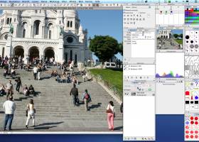 [ Zoom screenshot ] |
|
| Software Info | |
|
Best Vista Download periodically updates pricing and software information of PhotoLine full version from the publisher,
but some information may be out-of-date. You should confirm all information. Software piracy is theft, using crack, warez passwords, patches, serial numbers, registration codes, key generator, keymaker or keygen for PhotoLine license key is illegal and prevent future development of PhotoLine. Download links are directly from our mirrors or publisher's website, PhotoLine torrent files or shared files from rapidshare, yousendit or megaupload are not allowed! |
|
| Released: | April 03, 2020 |
| Filesize: | 17.30 MB |
| Platform: | Windows 2000, Windows 2003, Windows XP, Windows Vista, Windows Vista x64, Windows 7, Windows 7 x64, Windows 8, Windows 8 x64 |
| Install | Instal And Uninstall |
| Add Your Review or Windows Vista Compatibility Report |
PhotoLine- Releases History |
| Software: | PhotoLine 22.01 |
| Date Released: | Apr 3, 2020 |
| Status: | New Release |
| Release Notes: | Color Picker: negative values are now corrected Document window, no scrollbars: size adjustment of the document windows was not accurate Multiple pages, changing the page size: layers keep their relative position now Automatic text layers: Could no longer be created |
| Software: | PhotoLine 19.03 |
| Date Released: | Oct 30, 2015 |
| Status: | New Release |
| Release Notes: | New image functions like "Dehaze" and "Color To Transparency" Enhancements in the graphics and layout section: variable line styles, document color lists, placeholder layers, ... Extended PDF export: spot colors, overprinting, PDF/X1a and PDF/X3 |
| Software: | PhotoLine 18.51 |
| Date Released: | Sep 17, 2014 |
| Status: | New Release |
| Release Notes: | · PSD import: Crash when loading 16 bit adjustment layers fixed · PSD import: Loading adjustment layers improved · PSD brushes: Version 7 can be loaded now · PSD import: Color balance adjustment layers can be loaded now · Raw import: Wrong color bug fixed · TIFF import: Problem when loading pictures without stripbytecount fixed · WMF import: Right aligned text was read left aligned · IFF import: Can read true color pictures now · dcraw: Problem with pictures from Sigma cameras fixed · Automatic Lasso: A tolerance setting of 0 creates a free lasso now · GIF export: Virtual copies with own transparency (Layer Effects, Layer Masks, ...) did loose their transparency when exported · Save Mask: Crash fixed · Finger Tool: Transparent pictures got a transparent colors · PDF/TIFF import, Mac OS: Fax3/Fax4 pictures were sometimes read incorrect · Textur dialog: The preview did create redraw problems · Progress bar, Mac OS: The progress bar was over other programs |
Most popular maps in Editors downloads for Vista |
|
3DFieldPro x64 4.6.5 download by Vladimir Galouchko
... program. 3DFieldPro x64 converts your data into contour maps, surface or volume plots. 3DFieldPro x64 is an ... whose purpose is to help you create 2D/3D maps of contours (isolines) based on numerical data. In ...
type: Demo ($399.00)
View Details
Download
categories: x64 contour map, map creator x64, x64plot, x64map, data to plot x64, x64 create contour map, x64 surface plot, interpolation x64, x64 digitize image, x64 plotter, x64 map, x64 surface |
 |
|
Realtime Landscaping Architect 2014 6.02 download by Idea Spectrum, Inc.
... create hills, slopes, contour lines, berms, and height maps. Switch to the unique Realtime Walkthrough mode to move through your design as if you were really there. Create compelling landscape ...
type: Demo ($399.95)
View Details
Download
categories: landscape, landscaping, design, plan, pro, professional, garden, gardening, home, yard, backyard, deck, fence, pond, pool |
 |
|
Vextractor 7.20 download by VextraSoft
... Design software. You can also vectorize charts, drawings, maps and schemes for input to CAD or GIS systems. Main features of Vextractor: Input raster formats: BMP, GIF, TIFF, GeoTIFF, JPEG, ...
type: Shareware ($99.95)
View Details
Download
categories: raster to vector, image to vector, raster, vector, vectorise, vectorize, vectorization, vectorizing, trace, convert, conversion, r2v, scan, cad, autocad, dxf, tiff, gif, bmp.jpg, jpeg, polyline, centerline, outline, image, gis, digitize, digitizing |
 |
|
RoboGEO 6.3.2 download by Pretek, Inc.
Geotag digital images with latitude, longitude, altitude, and direction information. RoboGEO stamps this information onto the actual photo or writes it to the EXIF headers. In addition, RoboGEO allows you to ...
type: Demo ($79.95)
View Details
Download
categories: georeference image, Geographical Information System, geotag EXIF photo, geotag, reference, geocode |
 |
|
Image Constructor 2.5 download by Image Tools Group
... original illustrations, structural schemas and diagrams, simple geographical maps and location plants in form of texts and small images over some background with picture or gradient fill and save them ...
type: Shareware ($25.00)
View Details
Download
categories: imageconstructor, image, constructor, create illustration, presentation, picture, geographical map, plan, graphics, webgraphics, flowchart, diagram, schema, image collection, GIF, publishing, homepage, imageediting, web, business, software, downloads |
 |
|
3DFieldPro 4.6.7.0 download by Vladimir Galouchko
... and versatile software designed for creating three-dimensional surface maps and contour plots from a variety of data ... data into visually compelling 3D surfaces and contour maps. The software supports a wide range of input ...
type: Demo
View Details
Download
categories: geospatial tools, Vladimir Galouchko, Map Plotter, Data To Map, 3DFieldPro, Plotter, Plot, terrain analysis, data visualization, Mapper, Map Creator, mapping software, Create, 3DFieldPro free download, download 3DFieldPro |
 |
|
3DField 4.6.7.0 download by Vladimir Galouchko
... software designed for the creation of 3D surface maps and contour plots from your data sets. This ... in its rendering capabilities, producing high-quality 3D surface maps that are both visually appealing and highly informative. ...
type: Demo
View Details
Download
categories: surface, Vladimir Galouchko, map, data visualization, digitize image, download 3DField, terrain analysis, mapping software, 3DField free download, create contour map, 3DField, plotter, contour mapping, surface plot, mapper |
 |
|
Displacement Map 1.0 download by ImageSkill Software
... plug-in is supplied with a set of displacement maps. It is very useful for artistic image processing. The Displacement Map has a stylish, user-friendly, intuitive, multi-lingual interface. A user can ...
type: Freeware
View Details
Download
categories: image distortion, warping, bending, geometric displacement, bump mapping, displacement map, displacement mapping, displacement map, ImageSkil, plugin, plug-ins, photo |
 |
|
PhotoLine 22.01 download by Computerinsel
... Export * Tile images, create buttons and image maps Many more * Batch conversion * Create slideshows * Record actions * Print multipage documents, flyers and labels * ...
View Details
Download
|
 |
|
HDR Expose 2.1.1 build 9804 download by Unified Color
... data in your HDR image and "dynamic range maps" it into a file that retains naturally clear highlights, vibrant mid-tones and beautifully open shadows. HDR Expose can do this ...
View Details
Download
|