Related Keywords
map downloadsmap drive downloads
map component downloads
map engine downloads
map network drive downloads
map serial port downloads
map files downloads
map open ports to process downloads
map point downloads
map middle earth downloads
map viewer downloads
map software downloads
map maker downloads
map editor downloads
map plot points downloads
map creator downloads
map plus personal media downloads
map plus downloads
map folder downloads
map programs downloads
Top Software Keywords
tool downloadsdigital downloads
pdf downloads
image downloads
design downloads
photo downloads
images downloads
jpeg downloads
adobe downloads
photos downloads
processing downloads
color downloads
scanner downloads
graphics downloads
bmp downloads
jpg downloads
screen downloads
photoshop downloads
picture downloads
graphic downloads
zoom downloads
print downloads
utility downloads
pictures downloads
corel downloads
video downloads
gif downloads
printing downloads
watermark downloads
paint downloads
Vista Download
Vista downloadVista antivirus download
Vista wallpaper download
Vista wallpapers download
Vista themes download
Vista pack download
Vista ultimate download
Vista home download
Vista basic download
Vista business download
Vista x64 download
Vista transformation download
Vista transformation pack download
Vista boot download
Vista dvd download
Vista sidebar download
Vista aero download
Vista product key download
Downloads RSS

Top Downloads
Top Rated
Navigation: Home
\ Graphic Apps
\ Other \ TatukGIS Viewer
TatukGIS Viewer5.83.0.3269 by TatukGIS |

|
Software Description:
TatukGIS Viewer is a powerful, free GIS application that allows users to visualize, analyze, and edit geospatial data with ease. Designed for both professionals and enthusiasts, it supports a wide range of formats, including vector and raster data. The intuitive interface makes navigation seamless, while advanced features like layer management, spatial analysis tools, and customizable symbology enhance user experience. Ideal for anyone needing robust GIS capabilities without the complexity, Tatu ... ...
type: Freeware
Download TatukGIS Viewercategories: TatukGIS Viewer, download TatukGIS Viewer, TatukGIS Viewer free download, raster image Viewer, GIS editor, GIS map, viewer, graphic, view, edit Add to Download Basket Report virus or spyware |
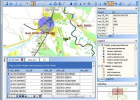 [ Zoom screenshot ] |
|
| Software Info | |
|
Best Vista Download periodically updates pricing and software information of TatukGIS Viewer full version from the publisher,
but some information may be out-of-date. You should confirm all information. Software piracy is theft, using crack, warez passwords, patches, serial numbers, registration codes, key generator, keymaker or keygen for TatukGIS Viewer license key is illegal and prevent future development of TatukGIS Viewer. Download links are directly from our mirrors or publisher's website, TatukGIS Viewer torrent files or shared files from rapidshare, yousendit or megaupload are not allowed! |
|
| Released: | March 01, 2025 |
| Filesize: | 175.00 MB |
| Platform: | Windows 11, Windows Server 2019, Windows Server 2016, Windows 10 32/64 bit, Windows Server 2012, Windows 2008 32/64 bit, Windows 2003, Windows 8 32/64 bit, Windows 7 32/64 bit, Windows Vista |
| Install | Instal And Uninstall |
| Add Your Review or Windows Vista Compatibility Report |
TatukGIS Viewer- Releases History |
| Software: | TatukGIS Viewer 5.83.0.3269 |
| Date Released: | Mar 1, 2025 |
| Status: | New Release |
| Release Notes: | Bugs: [EDT-3492] Viewer does not start due to a missed license (VWR) |
| Software: | TatukGIS Viewer 5.88.0.3244 |
| Date Released: | Dec 28, 2024 |
| Status: | New Release |
| Release Notes: | New features: CenterByWGS script to center and zoom map based on latitude longitude (EDT,Scripting) Bugs: Closing python created form can cause instability (EDT,Python,Scripting) Wait for external debugger is not reliable (EDT,Python) Non-modal forms created by Python are sometimes causes AV upon closing. (EDT,Python) Improvements: Auto styling of layer and legend reperesantion to be improved. (Core) |
| Software: | TatukGIS Viewer 5.79.0.3231 |
| Date Released: | Nov 29, 2024 |
| Status: | New Release |
| Release Notes: | New features: CenterByWGS script to center and zoom map based on latitude longitude (EDT,Scripting) Bugs: Closing python created form can cause instability (EDT,Python,Scripting) Wait for external debugger is not reliable (EDT,Python) Non-modal forms created by Python are sometimes causes AV upon closing. (EDT,Python) Improvements: Auto styling of layer and legend reperesantion to be improved. (Core) |
Most popular map in Other downloads for Vista |
|
MindOnMap 1.0.20 download by MindOnMap Studio
... main idea in the center of your mind map. You can add Main Nodes and some Sub ... functions. When you want to create a mind map in a quick way, you can choose from ...
View Details
Download
|
 |
|
Triaxes 3DMasterKit 11.1 download by Triaxes
... slidebar (stereo shooting). - Layers and Depth Map 3DMasterKit creates 3D images out of a single ... of 3D effect. 3DMasterKit also uses a depth map for each separate layer to build up a ...
type: Demo ($102.60)
View Details
Download
categories: photo, effect, image, 3D image creator, lenticular picture creator, stereoscope image, designer, anaglyph, stereoscope, editor |
 |
|
WeatherStudio 2 download by PaulMarv Software
... data, products, maps, and charts into a single map that the user can pan and zoom. GFS/NDFD/NAM/RAP Model Data, Placefiles, Radar Loops, Satellite, Storm Reports, Hurricane Paths, Surface Observations, Watches/Warnings, ...
type: Shareware ($80.00)
View Details
Download
categories: weather, weather tracking software, storm tracking software, weather data, noaa, nws, radar, satellite, software, hurricanes, storms, blizzards, graphics, animations, meteorology, storm chasing, tornadoes, severe weather, spotter, placefiles, model data, GFS, NAM, RAP |
 |
|
Name Dropper 3.7 download by Cognitial Software
... and functions too! Name Dropper allows you to map (connect) network drives to a local drive letter (and un-map / disconnect them as well). You can also execute a "Search ...
type: Demo ($10.00)
View Details
Download
categories: name dropper, rename multiple image, name changer, name, change, changer |
 |
|
World Heatmap Creator 1.4 download by VOVSOFT
... parameter value using color codes throughout a regular map. Aside from being visually appealing, these statistical instruments ... simple manner. World Heatmap Creator creates a world map in HTML format and marks all the locations ...
View Details
Download
|
 |
|
ClickCharts FlowCharts Software Pro 3.09 download by NCH Software
Create flowcharts easily with this Windows software. Whether you're mapping out ideas, laying out the structure of your organization or creating UML diagrams, ClickCharts is the perfect user-friendly program to get ...
View Details
Download
|
 |
|
Mkgmap 4922 download by Steve Ratcliffe
... designed to convert OpenStreetMap (OSM) data into Garmin-compatible map files. This powerful utility serves a niche but ... offers extensive customization options, allowing users to define map styles, include or exclude specific data elements, and ...
type: Open Source
View Details
Download
categories: route, GPS, Mkgmap, mapping, OSM to IMG, create map, software, Steve Ratcliffe, mapper, open-source, GPS map, Mkgmap free download, download Mkgmap, OSM2IMG |
 |
|
GeoSetter 3.5.3 download by Friedemann Schmidt
... image directions and tracks on embedded Google Maps map (requires internet connection) Setting geo data by using embedded Google Maps map (requires internet connection) or by entering known values ...
type: Freeware
View Details
Download
categories: change geographical data, change picture date, geo tag images, synchronize, geographic, localication |
 |
|
AMP Tile Viewer 2.01 download by AMPSoft
... · Kodak Photo-CD images (*.pcd) · Portable Pixel/Gray Map images (*.ppm, *.pgm, *.pbm) · Zoom in and zoom out control. · Option of showing a grid that delimitates the ...
View Details
Download
|
 |
|
ACDSee Canvas 12 with GIS+ 12.00.1389 download by ACD Systems
... that support all leading GIS formats, define complex map projections, and perform advanced property operations. Canvas provides you with a single integrated software environment for technical illustration. With Canvas, you ...
type: Shareware ($899.00)
View Details
Download
categories: Technical illustration, CAD, precision drawing, aerospace, biotechnology manufacturing, oil, gas, vector, raster, WebCGM, CGM, CGM4, flowchart, GIS, visualization, technical graphics, dimensioning, IEEE |