Related Keywords
map downloadsmap drive downloads
map component downloads
map engine downloads
map network drive downloads
map serial port downloads
map files downloads
map open ports to process downloads
map point downloads
map middle earth downloads
map viewer downloads
map software downloads
map maker downloads
map editor downloads
map plot points downloads
map creator downloads
map plus personal media downloads
map plus downloads
map folder downloads
map programs downloads
Top Software Keywords
autocad downloadscad downloads
3d cad downloads
drawing downloads
import downloads
design downloads
dwg downloads
pdf to dwg downloads
dxf downloads
convert downloads
convert pdf to dwg downloads
dwg to pdf downloads
converter downloads
dxf to pdf downloads
pdf to dxf downloads
dwf to dwg downloads
dwg to dxf downloads
dwg converter downloads
dwg to jpg downloads
dwg to bmp downloads
stl downloads
dxf to pcl downloads
dwg to tiff downloads
intellicad downloads
pdf to cad downloads
dwg to gif downloads
convert dwg to pdf downloads
dwg to png downloads
dwg to dwf downloads
dxf to ps downloads
Vista Download
Vista downloadVista antivirus download
Vista wallpaper download
Vista wallpapers download
Vista themes download
Vista pack download
Vista ultimate download
Vista home download
Vista basic download
Vista business download
Vista x64 download
Vista transformation download
Vista transformation pack download
Vista boot download
Vista dvd download
Vista sidebar download
Vista aero download
Vista product key download
Downloads RSS
Top Downloads
Top Rated
Navigation: Home
\ Graphic Apps
\ CAD \ Panoply
Panoply5.4.3 by Robert B. Schmunk |

|
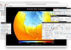
Software Description:
Panoply is an utility that enable user to plot raster image. Depending on the data, it can draw global longitude-latitude images or pole-to-pole latitude-vertical images.Panoply is a cross-platform application which plots geo-gridded arrays from netCDF, HDF and GRIB datasets. ...
type: Freeware
Download Panoplycategories: plot raster image, longitude image, pole-to-pole image, raster image, rasterize, raster Add to Download Basket Report virus or spyware |
 [ Zoom screenshot ] |
|
| Software Info | |
|
Best Vista Download periodically updates pricing and software information of Panoply full version from the publisher,
but some information may be out-of-date. You should confirm all information. Software piracy is theft, using crack, warez passwords, patches, serial numbers, registration codes, key generator, keymaker or keygen for Panoply license key is illegal and prevent future development of Panoply. Download links are directly from our mirrors or publisher's website, Panoply torrent files or shared files from rapidshare, yousendit or megaupload are not allowed! |
|
| Released: | June 24, 2024 |
| Filesize: | 34.00 MB |
| Platform: | Windows XP, Windows Vista, Windows Vista x64, Windows 7, Windows 7 x64, Windows 8, Windows 8 x64, Windows 10, Windows 10 x64, Windows 11 |
| Install | Instal And Uninstall |
| Add Your Review or Windows Vista Compatibility Report |
Panoply- Releases History |
| Software: | Panoply 5.4.3 |
| Date Released: | Jun 24, 2024 |
| Status: | New Release |
| Software: | Panoply 5.4.1 |
| Date Released: | Jun 1, 2024 |
| Status: | New Release |
| Software: | Panoply 5.4.0 |
| Date Released: | May 11, 2024 |
| Status: | New Release |
Most popular map in CAD downloads for Vista |
|
ExpertGPS 8.64 download by TopoGrafix
... you can draw your route directly on a map, search for nearby features from the millions of ... so you can quickly define an area to map and let ExpertGPS gather the data later. ExpertGPS ...
View Details
Download
|
 |
|
TNTatlas 2024 B20240606 download by MicroImages, Inc.
... — from a single geodata file to complex map layouts prepared using TNTmips. TNTatlas lets you display ... have to rapidly assemble and distribute existing electronic map and database materials for those working in natural ...
type: Freeware
View Details
Download
categories: geospatial viewer, view atlas, visualize geospatial data, atlas, map, viewer |
 |
|
TNTmips 20240404 download by MicroImages, Inc.
... of geospatial data including imagery, terrain surfaces, and map data with associated database attributes. It provides all ... published on the Internet as web tilesets, Web Map Service (WMS), and ArcIMS ... Automatically generate ...
type: Freeware
View Details
Download
categories: GIS data analysis, analyze geodetic data, edit GIS dataset, GIS, dataset, editor, analysis |
 |
|
TrueSpace 7.61 download by Caligari Corporation
... that need different textures, and then export that map to a 2D editor so that you can draw and create the textures needed. · The scene on the right ...
type: Freeware
View Details
Download
categories: truespace 3, truespace 6.5, truespace 7, truespace 7.5, truespace, truespace 7.51, truespace trial, truespace models, True Space |
 |
|
TransLT 15.0 download by 3D Space
... operations: * coordinates conversions (including using a map projection); * polynomial transformations; * transformations using grid files (files containing corrections values); * transformations with parameters: 1D, 2D or 3D; ...
type: Trialware ($250.00)
View Details
Download
categories: calculate transformation parameter, coordinate transformation, transformation parameter, calculate, geodetic, GPS |
 |
|
MagicPlot Student 2.9.3 download by MagicPlot.com
... - Data processing - Multiple axes - Color map plots - Figure templates - Batch processing ...
View Details
Download
|
 |
|
CueMol 2.2.3.442 download by BKR Laboratory
... format), MSMS surface data, and GRASP electrostatic potential map. ...
type: Freeware
View Details
Download
categories: view macromolecular structure, macromolecular structure visualization, visualize macromolecular structure, viewer, view, visualize |
 |
|
GPS Utility 5.51 download by GPS Utility Ltd.
... text formats. The program converts between different map datums and many coordinate formats (Lat/Long, UTM/UPS, country ... You can plot your GPS information as a map and add map annotations in text or image ...
type: Demo ($60.00)
View Details
Download
categories: Waypoint Manager, GPS Receiver, Digitise GPS, Waypoint, GPD, Digitise |
 |
|
Bifido Punnett Square Calculator Pro 3.4 download by Bifidosoft
... it includes: Punnett Square Calculator Crossing Over Map Calculator Fruit Fly Sex Calculator Recombination Progeny Calculator ...
type: Freeware
View Details
Download
categories: Punnett Square Calculator, gene calculator, Genetics Calculator, genetics, Punnett Square, calculator |
 |
|
Mobile Atlas Creator 2.2.1 download by Fredrik Moller
... exported as one large PNG image with calibration MAP file for OziExplorer. As source for an offline ... OpenStreetMap, Google Maps, Yahoo Maps and other online map providers. Features: Create offline atlases for ...
View Details
Download
|
 |