Related Keywords
map collection downloadscollection downloads
collection manager downloads
collection software downloads
collection catalog downloads
collection movies downloads
collection agencies downloads
collection of text files downloads
collection navigation downloads
collection agency system downloads
collection agency software downloads
collection database downloads
collection management downloads
collection agency outsourcing downloads
collection database system downloads
collection cover downloads
collection sort downloads
collection agency downloads
collection management software downloads
collection browser downloads
Top Software Keywords
photoshop downloadsphoto editing downloads
picture downloads
images downloads
graphics downloads
image editing downloads
photos downloads
image editor downloads
image downloads
effects downloads
gif downloads
editor downloads
photo editor downloads
free photo editor downloads
resize downloads
graphic downloads
digital downloads
edit downloads
texture downloads
digital photography downloads
free photo editing software downloads
jpeg downloads
photo downloads
photo editing software downloads
digital photo downloads
photography downloads
jpg downloads
bmp downloads
watermark downloads
batch downloads
Vista Download
Vista downloadVista antivirus download
Vista wallpaper download
Vista wallpapers download
Vista themes download
Vista pack download
Vista ultimate download
Vista home download
Vista basic download
Vista business download
Vista x64 download
Vista transformation download
Vista transformation pack download
Vista boot download
Vista dvd download
Vista sidebar download
Vista aero download
Vista product key download
Downloads RSS
Featured Download

AKVIS Enhancer
Photo Enhancement
Software

PicaJet FX
Digital photo
management software
Top Downloads
Top Rated
Navigation: Home
\ Graphic Apps
\ Editors \ Airphoto
Airphoto3.58 by Irwin Scollar |

|
Software Description:
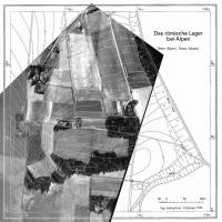
AirPhoto is an easy to use application that can process and edit old photos and calibrate maps. The program is intended for archaeologists that need to superimpose scanned maps and old pictures. The program can be used from a digital terrain model (DTM) if desired. Using AirPhoto, you can obtain images directly from a scanner or create mosaics. ...
Download AirphotoAdd to Download Basket Report virus or spyware |
 [ Zoom screenshot ] |
|
| Software Info | |
|
Best Vista Download periodically updates pricing and software information of Airphoto full version from the publisher,
but some information may be out-of-date. You should confirm all information. Software piracy is theft, using crack, warez passwords, patches, serial numbers, registration codes, key generator, keymaker or keygen for Airphoto license key is illegal and prevent future development of Airphoto. Download links are directly from our mirrors or publisher's website, Airphoto torrent files or shared files from rapidshare, yousendit or megaupload are not allowed! |
|
| Released: | April 08, 2013 |
| Filesize: | 23.20 MB |
| Platform: | Windows XP, Windows Vista, Windows Vista x64, Windows 7, Windows 7 x64 |
| Install | Instal And Uninstall |
| Add Your Review or Windows Vista Compatibility Report |
Airphoto- Releases History |
| Software: | Airphoto 3.58 |
| Date Released: | Apr 8, 2013 |
| Status: | New Release |
| Software: | Airphoto 3.56 |
| Date Released: | May 18, 2012 |
| Status: | New Release |
Most popular map collection in Editors downloads for Vista |
|
Image Constructor 2.5 download by Image Tools Group
... from a set of base objects and image collections; - adds objects from graphical files; - adds objects as a text line and coordinate axis; - manages list of objects; ...
type: Shareware ($25.00)
View Details
Download
categories: imageconstructor, image, constructor, create illustration, presentation, picture, geographical map, plan, graphics, webgraphics, flowchart, diagram, schema, image collection, GIF, publishing, homepage, imageediting, web, business, software, downloads |
 |
|
3DFieldPro 4.6.7.0 download by Vladimir Galouchko
... directly from databases, ensuring compatibility with most data collection methods. Its intuitive interface allows users to import data seamlessly, configure plot parameters, and generate high-quality visualizations with minimal effort. ...
type: Demo
View Details
Download
categories: geospatial tools, Vladimir Galouchko, Map Plotter, Data To Map, 3DFieldPro, Plotter, Plot, terrain analysis, data visualization, Mapper, Map Creator, mapping software, Create, 3DFieldPro free download, download 3DFieldPro |
 |
|
Airphoto 3.58 download by Irwin Scollar
... or the program can create one from a collection of manually entered or imported irregular heights. It ... corresponding control points in a picture and a map just by clicking the mouse. Color or black ...
View Details
Download
|
 |