Related Keywords
height downloadsheight percentile downloads
height rest downloads
height note downloads
height challenged downloads
height field analysis downloads
height and width downloads
increase height downloads
how to increase height downloads
increase your height downloads
change height downloads
dinning table and chair height downloads
gain height downloads
calculate height downloads
pixel height downloads
png height width changer downloads
increase pic height and width downloads
reducing video height width downloads
increasing height and width downloads
change height pixel downloads
Top Software Keywords
autocad downloads3d cad downloads
cad downloads
drawing downloads
import downloads
design downloads
dwg downloads
pdf to dwg downloads
dxf downloads
convert downloads
convert pdf to dwg downloads
dwg to pdf downloads
dxf to pdf downloads
converter downloads
pdf to dxf downloads
dwf to dwg downloads
dwg converter downloads
dwg to dxf downloads
dwg to jpg downloads
dwg to bmp downloads
stl downloads
dxf to pcl downloads
dwg to tiff downloads
intellicad downloads
pdf to cad downloads
dwg to gif downloads
convert dwg to pdf downloads
dwg to png downloads
dwg to dwf downloads
dxf to ps downloads
Vista Download
Vista downloadVista antivirus download
Vista wallpaper download
Vista wallpapers download
Vista themes download
Vista pack download
Vista ultimate download
Vista home download
Vista basic download
Vista business download
Vista x64 download
Vista transformation download
Vista transformation pack download
Vista boot download
Vista dvd download
Vista sidebar download
Vista aero download
Vista product key download
Downloads RSS
Top Downloads
Top Rated
Navigation: Home
\ Graphic Apps
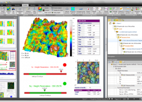
\ CAD \ MountainsMap Scanning Topography
MountainsMap Scanning Topography6.2.6266 by Digital Surf |

|
Software Description:
MountainsMap Scanning Topography is a professional application designed to perform surface analysis for 3D surface profilometers. With MountainsMap Scanning Topography, users will be able to easily analyze measurements and metrology data. It features an extensive set of surface texture parameters. ...
type: Trialware
Download MountainsMap Scanning Topographycategories: surface profilometer, scanning opography, surface analysis, topography, profilometer, surface Add to Download Basket Report virus or spyware |
 [ Zoom screenshot ] |
|
| Software Info | |
|
Best Vista Download periodically updates pricing and software information of MountainsMap Scanning Topography full version from the publisher,
but some information may be out-of-date. You should confirm all information. Software piracy is theft, using crack, warez passwords, patches, serial numbers, registration codes, key generator, keymaker or keygen for MountainsMap Scanning Topography license key is illegal and prevent future development of MountainsMap Scanning Topography. Download links are directly from our mirrors or publisher's website, MountainsMap Scanning Topography torrent files or shared files from rapidshare, yousendit or megaupload are not allowed! |
|
| Released: | September 29, 2014 |
| Filesize: | 511.00 MB |
| Platform: | Windows XP, Windows Vista, Windows Vista x64, Windows 7, Windows 7 x64 |
| Install | Instal And Uninstall |
| Add Your Review or Windows Vista Compatibility Report |
MountainsMap Scanning Topography- Releases History |
| Software: | MountainsMap Scanning Topography 6.2.6266 |
| Date Released: | May 3, 2012 |
| Status: | New Release |
| Release Notes: | Surface partitioning with or without leveling: · A sub-surface can be extracted with or without leveling using the Partition Leveling operator. Contour Analysis/Advanced Contour Analysis module enhancements: · Horizontal contour extraction with smoothing - parametric profiles extracted on the XY plane can be smoothed automatically. Integration of Chinese GB/T standards: · The "right parameters wherever you are" feature has been extended to include Chinese GB/T standard references for parameter families, which can be selected in Metrological Preferences - References. Advanced Contour Analysis module enhancements: · Automatic association of geometric elements with profiles - line segments, arcs and circles (greater than a specified minimum size) can be automatically associated with profiles. This significantly speeds up the definition of nominal form (which is otherwise carried out interactively or by fitting CAD DXF data to the profile). |
Most popular height in CAD downloads for Vista |
|
Model Air Design 2.4 download by William Busto
... can modify a wing in length, width or height, and you can position it higher, lower, forward or back. Model Air Design is not like a conventional CAD program. ...
type: Freeware
View Details
Download
categories: aircraft design, airplane design, design airplan, aircraft, airplane, design |
 |
|
Gwyddion 2.66 download by David Necas and Petr Klapetek
... analysis. Primarily it is intended for analysis of height fields obtained by scanning probe microscopy techniques (AFM, ... it can be generally used for any other height field and image analysis, for instance for analysis ...
type: Open Source
View Details
Download
categories: data visualization, data analysis, height field analysis, analyze, visualize, visualizer |
 |
|
Projectile Motion (Galileo and Newton) download by Todd Timberlake
... motion of the projectile for a given initial height, launch speed, and launch angle (all of which can be selected using the simulation controls). Optionally, the simulation will display the ...
type: Freeware
View Details
Download
categories: motion simulator, projectile simulator, motion simulation, motion, simulation, projectile |
") |
|
GGCad 2.1.0.5 download by GGSoft
... rate · Plunge rate · Deep · Maximum height pass · Tool number · Spindle speed · ... tool · Line numbering · Rapid plane movement height · Add start bloc to a file · ...
View Details
Download
|
 |
|
IGES Viewer alias ABViewer 14 download by CADSoftTools
... more detailed information about a 3D model: area, height between two parallel surfaces, the distance between two points, length of an edge and radius of a circle or a circular ...
type: Shareware ($66.00)
View Details
Download
categories: IGS, IGES, .igs, IGS viewer, 3D viewer, IGS to DWG, IGS to STL, IGS to JPEG, IGS to OBJ, IGS to DXF, convert, converter, measure, measuring, view, viewer, print, printing |
 |
|
Easy CAD to Image Converter 3.2 download by Benzsoft
... export area and line weight, specify output image height, width, DPI, and background color, grayscale output image ... area and line weight. · Specify output image height, width, DPI, and background color. · Grayscale output ...
type: Shareware ($99.00)
View Details
Download
categories: DWG to JPG, CAD to Image, DWG to Image, DXF to JPG, DWF to JPG, DXF to Image, DWF to Image, DWG2JPG, CAD2Image, DWG2Image, DXF2JPG, DWF2JPG, DXF2Image, DWF2Image, convert, converter, conversion |
 |
|
ProfLT 16.0 download by CADWARE Engineering
... depending on the type of printer selected; calculating height of platfom and drawing the labels of plaform heights; exporting the profiles in specific Micropiste or SdrMap ...
type: Trialware ($300.00)
View Details
Download
categories: AutoCAD tool, draw longitudinal profile, cross profiles, AutoCAD, Draw, Profile |
 |
|
MountainsMap Scanning Topography 6.2.6266 download by Digital Surf
... 2D and 3D surface texture parameters Calculate 3D height and bearing ratio parameters defined in the new ... Calculation of distances, angles, areas, volumes and step heights. 3D surface roughness analysis based on ISO 16610 ...
type: Trialware
View Details
Download
categories: surface profilometer, scanning opography, surface analysis, topography, profilometer, surface |
 |
|
LITIO 1.3.1 download by LITIO.si
... inside, outside, or mid cross sectional dimensions and/or height specifications; to draw or not the 3D surface, and the unfolded sheet as a mesh [to help you when bending the ...
type: Shareware ($29.88)
View Details
Download
categories: sheet metal, sheet, metal, square to round, rectangle to round, AutoCAD, GStarCAD, BricsCAD, ZWCad, hvac, parametric, development, transition, unfold, unfolder, bend, bender, sheetmetal, fittings, tube, pipe, duct, silo, hopper, blech, abwicklung, desarrollo |
 |
|
RapidSketch-Floor Plan & Area Calculator 2.3 download by Utilant, LLC
... wheel while drawing. Perimeter as well as segment height are shown allowing you to measure from inside or outside the home. *Automatically displays the angle and rise and run measurement ...
type: Shareware ($100.00)
View Details
Download
categories: RapidSketch, CAD, floor plan, area, sketch, appraiser, insurance inspector, flooring installer, calculate area, calculate perimeter, square footage, square meter, drag and drop, easily draw, floor plans, floor plan, floor plan layout, floor plan layouts |
 |