Related Keywords
gps downloadsgps c downloads
gps clock downloads
gps decoder downloads
gps nmea sentence downloads
gps toolkit downloads
gps serial port component downloads
gps component vb downloads
gps component c downloads
gps navigation downloads
gps receivers downloads
gps express downloads
gps software downloads
gps harta downloads
gps source code module downloads
gps chartplotters downloads
gps chartplotter downloads
gps utility downloads
gps map downloads
gps freeware downloads
Top Software Keywords
photoshop downloadsphoto editing downloads
picture downloads
images downloads
graphics downloads
image editor downloads
image editing downloads
photos downloads
image downloads
effects downloads
gif downloads
editor downloads
free photo editor downloads
resize downloads
photo editor downloads
graphic downloads
edit downloads
digital downloads
digital photography downloads
free photo editing software downloads
texture downloads
photo downloads
jpeg downloads
photo editing software downloads
digital photo downloads
photography downloads
bmp downloads
jpg downloads
watermark downloads
batch downloads
Vista Download
Vista downloadVista antivirus download
Vista wallpaper download
Vista wallpapers download
Vista themes download
Vista pack download
Vista ultimate download
Vista home download
Vista basic download
Vista business download
Vista x64 download
Vista transformation download
Vista transformation pack download
Vista boot download
Vista dvd download
Vista sidebar download
Vista aero download
Vista product key download
Downloads RSS
Featured Download

AKVIS Enhancer
Photo Enhancement
Software

PicaJet FX
Digital photo
management software
Top Downloads
Top Rated
Navigation: Home
\ Graphic Apps
\ Editors \ GPS Track Editor
GPS Track Editor1.15 B141 by GPS Track Editor |

|
Software Description:
GPS Track Editor is a Windows application for editing GPS tracks.GPS track is an ordered sequence of points with ... coordinates obtained from a receiver are not precise. GPS errors are affected by a number of reasons ... can show some movement while standing still. GPS Track Editor can help you to clean up your tracks. ...
type: Freeware
Download GPS Track Editorcategories: Edit GPS Track, GPS Track Cleaner, Merge GPS Tracks, Editor, GPS Track, Merge Add to Download Basket Report virus or spyware |
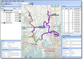 [ Zoom screenshot ] |
|
| Software Info | |
|
Best Vista Download periodically updates pricing and software information of GPS Track Editor full version from the publisher,
but some information may be out-of-date. You should confirm all information. Software piracy is theft, using crack, warez passwords, patches, serial numbers, registration codes, key generator, keymaker or keygen for GPS Track Editor license key is illegal and prevent future development of GPS Track Editor. Download links are directly from our mirrors or publisher's website, GPS Track Editor torrent files or shared files from rapidshare, yousendit or megaupload are not allowed! |
|
| Released: | August 11, 2015 |
| Filesize: | 7.60 MB |
| Platform: | Windows XP, Windows Vista, Windows Vista x64, Windows 7, Windows 7 x64, Windows 8, Windows 8 x64, Windows 10, Windows 10 x64 |
| Install | Instal And Uninstall |
| Add Your Review or Windows Vista Compatibility Report |
GPS Track Editor- Releases History |
| Software: | GPS Track Editor 1.15 B141 |
| Date Released: | Aug 11, 2015 |
| Status: | New Release |
| Software: | GPS Track Editor 1.09 Build 1 |
| Date Released: | Apr 2, 2014 |
| Status: | New Release |
| Release Notes: | · More maps are available as a background (select View | Map Layer or use a drop-down list on the toolbar). · Supported PTNL,GGK NMEA message used by Trimble GPS receivers. |
| Software: | GPS Track Editor 1.08 Build 1 |
| Date Released: | Aug 19, 2013 |
| Status: | New Release |
| Release Notes: | · More maps are available as a background (select View | Map Layer or use a drop-down list on the toolbar). · Supported PTNL,GGK NMEA message used by Trimble GPS receivers. |
Most popular gps c in Editors downloads for Vista |
|
Exif Tag Remover 4.3 download by RL Vision
... There are many different tags, for example Exif, GPS, IPTC & XMP, just to name a few. Although mostly a useful compliment to the picture, there are many reasons ...
View Details
Download
|
 |
|
JPEG Resampler 2010 6.0.4.7 download by David Macek
... several special effects offered * supports adding of GPS coordinates of the photo based on GPX * Shell context support - program can integrate into Windows Explorer (rightclick an image ...
View Details
Download
|
 |
|
JPEG Resampler 6.3.1 download by David Macek
... several special effects offered * supports adding of GPS coordinates of the photo based on GPX * Shell context support - program can integrate into Windows Explorer (rightclick an image ...
View Details
Download
|
 |
|
JPEG Resampler Portable 6.3.1 download by David Macek
... several special effects offered * supports adding of GPS coordinates of the photo based on GPX * Shell context support - program can integrate into Windows Explorer (rightclick an image ...
View Details
Download
|
 |
|
iWatermark Pro for Windows 2.5.25 download by Plum Amazing
... profiles * Add, remove and edit metadata (EXIF, GPS and XMP). * Unlimited fonts * Great Manual and support * Share to Facebook, Flickr, Instagram, Twitter and many more * ...
type: Shareware ($30.00)
View Details
Download
categories: photo, photos, watermark, watermarks, watermarking, signature, text, camera, resize, rename, exif, xmp, batch, workflow, photography, canon, nikon, fuji, olympus, autograph, copyright, trademark, digimarc, documents, magazine, stylus, transparency |
 |
|
iWatermark Pro 2 for Windows 4.0.27 download by Plum Amazing
... profiles * Add, remove and edit metadata (EXIF, GPS and XMP) * Use EXIF/IPTC/GPS data in the Text Watermark as tags to use the metadata in watermarks * Great Manual ...
type: Shareware ($30.00)
View Details
Download
categories: watermark, watermarks, watermarking, photo, photos, signature, text, camera, resize, rename, exif, xmp, batch, workflow, photography, canon, nikon, fuji, olympus, autograph, copyright, trademark, digimarc, documents, magazine, stylus, Win 10, Win 11 |
 |
|
CodedColor PhotoStudio Pro 8.4.0 download by 1STEIN Corp.
... CD/DVD burning, flash album export, new RAW formats, GPS tagging, 50 effects, clipart gallery, transparency & alpha channel, perspektive correction, search & compare similar images, color replacement brush, wizard & ...
type: Freeware
View Details
Download
categories: viewer, photo, image, editor, graphics, archive, album, publish, dtp, JPG, JPEG, GIF, TIF, RAW, BMP, WMF, PDF, organize, print, view, thumbs, catalog, camera, batch, conversion, exif, iptc, multimedia, acdsee, panorama, gps, balance, picasa, flash |
 |
|
RoboGEO 6.3.2 download by Pretek, Inc.
... permanently geotag and link your photos to the GPS coordinates. All writing to the EXIF and IPTC headers is lossless and all of the existing comments (including the MakerNote ...
type: Demo ($79.95)
View Details
Download
categories: georeference image, Geographical Information System, geotag EXIF photo, geotag, reference, geocode |
 |
|
Photo Stamper 4.1 download by Arman Lalane
... also can insert/update copyright information, description, title and GPS location within the picture based on Exif standards. The tool uses the GPS information within the picture to locate where the
type: Shareware ($24.99)
View Details
Download
categories: photo, manipulation, picture, insert text, rotate, resize, remove red eyes, stamper, stamp, engrave, crop image, adjust colors, copy, flip, exif, download, text, date, time, corner, preserve quality, full screen, preview, slide show, shell integration, mastering, gps, location |
 |
|
Dr. Regener LandMap Vivo 10 download by GPSsur Dr. Erhard Regener
... dataexchange with Google Earth by Copy and Paste, GPS enabled coordinates, import of free OpenStreatMap data and GPS Exchange and GPS logger data, compatible with "GPS for Google Earth", ...
type: Shareware ($65.00)
View Details
Download
categories: Map, geodata, wgs84, aereal photo, orthophoto, GPS, openstreetmap, google earth, virtual earth, roadmap, landmap, satellite, kml, kmz, onlinemaps, GPX |
 |