Related Keywords
gis data analysis downloadsgis data downloads
data analysis downloads
data analysis tool downloads
data analysis software downloads
data analysis tools downloads
data analysis plugins downloads
data analysis framework downloads
data analysis and reporting tool downloads
exploratory data analysis downloads
4tops data analysis downloads
excel data analysis downloads
qualitative data analysis downloads
multivariate data analysis downloads
biological data analysis downloads
sql data analysis downloads
scientific data analysis downloads
array data analysis downloads
csi data analysis downloads
binary data analysis downloads
Top Software Keywords
autocad downloadscad downloads
3d cad downloads
drawing downloads
import downloads
design downloads
dwg downloads
pdf to dwg downloads
dxf downloads
convert downloads
convert pdf to dwg downloads
dwg to pdf downloads
converter downloads
dxf to pdf downloads
pdf to dxf downloads
dwf to dwg downloads
dwg to dxf downloads
dwg converter downloads
dwg to jpg downloads
dwg to bmp downloads
stl downloads
dxf to pcl downloads
dwg to tiff downloads
intellicad downloads
pdf to cad downloads
dwg to gif downloads
convert dwg to pdf downloads
dwg to png downloads
dwg to dwf downloads
dxf to ps downloads
Vista Download
Vista downloadVista antivirus download
Vista wallpaper download
Vista wallpapers download
Vista themes download
Vista pack download
Vista ultimate download
Vista home download
Vista basic download
Vista business download
Vista x64 download
Vista transformation download
Vista transformation pack download
Vista boot download
Vista dvd download
Vista sidebar download
Vista aero download
Vista product key download
Downloads RSS
Top Downloads
Top Rated
Navigation: Home
\ Graphic Apps
\ CAD \ TNTmips
TNTmips20240404 by MicroImages, Inc. |

|
Software Description:
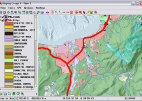
... tool that allows you to analyze and modify GIS images. It is a professional application that can handle desktop cartography, electronic atlas preparation and spatial database management. ...
type: Freeware
Download TNTmipscategories: GIS data analysis, analyze geodetic data, edit GIS dataset, GIS, dataset, editor, analysis Add to Download Basket Report virus or spyware |
 [ Zoom screenshot ] |
|
| Software Info | |
|
Best Vista Download periodically updates pricing and software information of TNTmips full version from the publisher,
but some information may be out-of-date. You should confirm all information. Software piracy is theft, using crack, warez passwords, patches, serial numbers, registration codes, key generator, keymaker or keygen for TNTmips license key is illegal and prevent future development of TNTmips. Download links are directly from our mirrors or publisher's website, TNTmips torrent files or shared files from rapidshare, yousendit or megaupload are not allowed! |
|
| Released: | April 04, 2024 |
| Filesize: | 121.00 MB |
| Platform: | Windows XP, Windows Vista, Windows Vista x64, Windows 7, Windows 7 x64, Windows 8, Windows 8 x64, Windows 10, Windows 10 x64, Windows 11 |
| Install | Instal And Uninstall |
| Add Your Review or Windows Vista Compatibility Report |
TNTmips- Releases History |
| Software: | TNTmips 20240404 |
| Date Released: | Apr 4, 2024 |
| Status: | New Release |
| Software: | TNTmips 20240131 |
| Date Released: | Jan 31, 2024 |
| Status: | New Release |
| Software: | TNTmips 20240108 |
| Date Released: | Jan 8, 2024 |
| Status: | New Release |
Most popular gis data analysis in CAD downloads for Vista |
|
JMARS for Windows 3.1.5 download by Arizona State University
... an acronym that stands for Java Mission-planning and Analysis for Remote Sensing. It is a geospatial information ... Space Flight Facility to provide mission planning and data-analysis tools to NASA's orbiters, instrument team members, students ...
type: Freeware
View Details
Download
categories: mission analysis, geospatial information, GIS analysis, mission, analysis, GIS |
 |
|
Thuban for Windows 1.2.2 download by Thuban Development Team
Thuban is an interactive geographic data viewer (GIS viewer) which features methods to visualize, ... geographic information. Thuban is an Interactive Geographic Data Viewer with the following features: # Vector ...
type: Open Source
View Details
Download
categories: geographic data viewer, gis viewer, analyze geographic information, information, geographic, viewer |
 |
|
TNTmips 20240404 download by MicroImages, Inc.
... you work with virtually any type of geospatial data including imagery, terrain surfaces, and map data with associated database attributes. It provides all the tools you need ... georeference, interpret, and publish any type of geospatial data. TNTmips provides professional geospatial tools in a single ...
type: Freeware
View Details
Download
categories: GIS data analysis, analyze geodetic data, edit GIS dataset, GIS, dataset, editor, analysis |
 |
|
CARIS Easy View 4.2.13 download by CARIS
... simple application that enables you to view spatial data imported from numerous types of files. It allows ... order and adjust object parameters. View your spatial data using the free CARIS viewer. CARIS Easy View ...
View Details
Download
|
 |
|
QGIS 3.36.1 download by Gary Sherman
QGIS is a professional GIS application that is built on top of and ... Software (FOSS). QGIS supports vector, raster, and database formats and lets you browse and create map data on your computer. QGIS supports many common ...
type: Open Source
View Details
Download
categories: geographic information system, map creator, map viewer, GIS, geographic information, create, QGIS |
 |