Related Keywords
geo downloadsgeo data downloads
geo spider downloads
geo gizmo 3d downloads
geo world downloads
geo location downloads
geo targeting downloads
geo referencing downloads
geo coding downloads
geo reference downloads
geo coordinates downloads
geo tag images downloads
geo walk downloads
geo information downloads
geo circle contact lenses downloads
geo blocked downloads
geo fence downloads
geo imaging downloads
geo algorithms downloads
geo seo downloads
Top Software Keywords
odbc downloadsdatabase downloads
sql downloads
data downloads
access downloads
excel downloads
tool downloads
table downloads
oracle downloads
dbf downloads
export downloads
sql server downloads
microsoft downloads
mysql downloads
server downloads
csv downloads
gui downloads
import downloads
management downloads
query downloads
development downloads
convert downloads
conversion downloads
utility downloads
tables downloads
dictionary downloads
migrate downloads
vista transformation downloads
ems downloads
sqlmanager downloads
Vista Download
Vista downloadVista antivirus download
Vista wallpaper download
Vista wallpapers download
Vista themes download
Vista pack download
Vista ultimate download
Vista home download
Vista basic download
Vista business download
Vista x64 download
Vista transformation download
Vista transformation pack download
Vista boot download
Vista dvd download
Vista sidebar download
Vista aero download
Vista product key download
Downloads RSS
Top Downloads
Top Rated
Navigation: Home
\ Business
\ Databases & Tools \ Geodata International
Geodata International13.03 by Killet GeoSoftware Ing.-GbR |

|
Software Description:
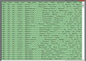
Geodata International - World-wide database of countries with georeferenced towns, municipalities, postal codes and administrative units with WGS84 and UTM coordinates and elevations for geocoding, proximity search, navigation, distance calculation. The database tables are present in the file format CSV (Comma Separated Values). The character set used is UTF8. This format is used often and in most cases you can import th data directly. ...
type: Data Only ($165.00)
Download Geodata Internationalcategories: geo, data, geodata, point, pointdata, spatial, reference, coding, coordinates, places, local, localities, town, quarters, postal, zip, code, periphery, search, distance, calculation, elevation, list, listing, municipality, database, longitude, latitude, geographic, utm, wgs84 Add to Download Basket Report virus or spyware |
 [ Zoom screenshot ] |
|
| Software Info | |
|
Best Vista Download periodically updates pricing and software information of Geodata International full version from the publisher,
but some information may be out-of-date. You should confirm all information. Software piracy is theft, using crack, warez passwords, patches, serial numbers, registration codes, key generator, keymaker or keygen for Geodata International license key is illegal and prevent future development of Geodata International. Download links are directly from our mirrors or publisher's website, Geodata International torrent files or shared files from rapidshare, yousendit or megaupload are not allowed! |
|
| Released: | June 11, 2021 |
| Filesize: | 2.28 MB |
| Language: | English, Dutch, French, German, Italian, Portuguese, Spanish |
| Platform: | Win2000, Windows XP, Windows 7 x32, Windows 7 x64, Windows 8, Windows 10, WinServer, WinOther, Windows Vista, Windows Vista x64 |
| Requirements: | All systems |
| Install | Install Only |
| Add Your Review or Windows Vista Compatibility Report |
Geodata International- Releases History |
| Software: | Geodata International 13.03 |
| Date Released: | Jun 11, 2021 |
| Status: | Major Update |
| Release Notes: | All databases updated to on status April 2021. Database "Germany" updated on status 1 January 2021. High-resolution country versions without extra charge. Ten new countries added. Google Plus code coordinates added to all data tables. World time UTC_DIF and beginning / end of Daylight Saving Time. |
| Software: | Geodata International 8.00 |
| Date Released: | Feb 25, 2016 |
| Status: | Major Update |
| Release Notes: | Germany database updated to release January 2016. 249 country databases total. 15 new country databases with release January 2015 added. 238 country databases on release January 2015 actualized. New country group 'Middle East'. |
Most popular geo in Databases & Tools downloads for Vista |
|
ORTWIN 17.03 download by Killet GeoSoftware Ing.-GbR
... searches a data base with more than 120.000 geo coded localities is available. The program represents local data, determined by local inquiries and perimeter searches, in graphic overviews and data ...
type: Shareware ($125.00)
View Details
Download
categories: local, index, register, place, locality, town, city, cities, quarter, geo, coding, periphery, perimeter, search, distance, municipality, district, coordinate, coordinates, elevation, longitude, latitude, snow load, wind load, landscape, center, distance, transformation |
 |
|
TOPOWIN 20.01 download by Killet GeoSoftware Ing.-GbR
... the German Basic Cartography and of localities with geo references in different coordinate systems. It is also a topographic information system. In the division of planning and execution of economical ...
type: Shareware ($125.00)
View Details
Download
categories: topography, geodetics, geography, corner, box, coordinate, map, guide, TK25, TK50, TK50, TK100, TKUE200, GK5, DGK5, geosoftware, registers, place, topowin, topo, placelist, information, system, measuring |
 |
|
Geodata International 13.03 download by Killet GeoSoftware Ing.-GbR
Geodata International - World-wide database of countries with georeferenced towns, municipalities, postal codes and administrative units with WGS84 and UTM coordinates and elevations for geocoding, proximity search, navigation, distance calculation. Often ...
type: Data Only ($165.00)
View Details
Download
categories: geo, data, geodata, point, pointdata, spatial, reference, coding, coordinates, places, local, localities, town, quarters, postal, zip, code, periphery, search, distance, calculation, elevation, list, listing, municipality, database, longitude, latitude, geographic, utm, wgs84 |
 |