Related Keywords
elevation downloadselevation view symbols downloads
bulding elevation surveys downloads
rack elevation downloads
symbols in elevation view downloads
create elevation map downloads
super elevation downloads
edit elevation dataset downloads
x64 edit elevation dataset downloads
Top Software Keywords
autocad downloads3d cad downloads
cad downloads
drawing downloads
import downloads
design downloads
dwg downloads
pdf to dwg downloads
dxf downloads
convert pdf to dwg downloads
convert downloads
dwg to pdf downloads
dxf to pdf downloads
converter downloads
pdf to dxf downloads
dwf to dwg downloads
dwg converter downloads
dwg to jpg downloads
dwg to dxf downloads
dwg to bmp downloads
stl downloads
dxf to pcl downloads
dwg to tiff downloads
intellicad downloads
pdf to cad downloads
dwg to gif downloads
convert dwg to pdf downloads
dwg to png downloads
dwg to dwf downloads
dxf to ps downloads
Vista Download
Vista downloadVista antivirus download
Vista wallpaper download
Vista wallpapers download
Vista themes download
Vista pack download
Vista ultimate download
Vista home download
Vista basic download
Vista business download
Vista x64 download
Vista transformation download
Vista transformation pack download
Vista boot download
Vista dvd download
Vista sidebar download
Vista aero download
Vista product key download
Downloads RSS
Top Downloads
Top Rated
Navigation: Home
\ Graphic Apps
\ CAD \ PreviSat
PreviSat6.1.0.3 by Astropedia |

|
Software Description:
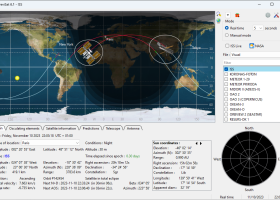
PreviSat is a satellite tracking program designed for observing purposes. PreviSat enables you to manage TLE orbital elements by updating the categories of orbital elements from the Internet and uploading data from TXT, TLE, or GZ file format. PreviSat is able to make predictions of their passes and also Iridium flares. ...
type: Open Source
Download PreviSatcategories: track satellite, satellite tracker, satellite position, track, tracker, position Add to Download Basket Report virus or spyware |
 [ Zoom screenshot ] |
|
| Software Info | |
|
Best Vista Download periodically updates pricing and software information of PreviSat full version from the publisher,
but some information may be out-of-date. You should confirm all information. Software piracy is theft, using crack, warez passwords, patches, serial numbers, registration codes, key generator, keymaker or keygen for PreviSat license key is illegal and prevent future development of PreviSat. Download links are directly from our mirrors or publisher's website, PreviSat torrent files or shared files from rapidshare, yousendit or megaupload are not allowed! |
|
| Released: | November 13, 2023 |
| Filesize: | 23.20 MB |
| Platform: | Windows XP, Windows Vista, Windows Vista x64, Windows 7, Windows 7 x64, Windows 8, Windows 8 x64, Windows 10, Windows 10 x64, Windows 11 |
| Install | Instal And Uninstall |
| Add Your Review or Windows Vista Compatibility Report |
PreviSat- Releases History |
| Software: | PreviSat 6.1.0.3 |
| Date Released: | Nov 13, 2023 |
| Status: | New Release |
| Software: | PreviSat 6.0.0.15 |
| Date Released: | Jun 24, 2023 |
| Status: | New Release |
| Software: | PreviSat 5.1.2.2 |
| Date Released: | Dec 29, 2022 |
| Status: | New Release |
Most popular elevation in CAD downloads for Vista |
|
JMARS for Windows 3.1.5 download by Arizona State University
... Take multiple datasets (thermal inertia, mineral composition, digital elevations, etc.) and overlay them into a single, registered ... on the map, making it easy to sample elevation, thermal inertia, or other surface properties in an ...
type: Freeware
View Details
Download
categories: mission analysis, geospatial information, GIS analysis, mission, analysis, GIS |
 |
|
PreviSat 6.1.0.3 download by Astropedia
... specifying the start and end date, location, Sun elevation, minimal elevation of the satellite, and other details. The results ...
type: Open Source
View Details
Download
categories: track satellite, satellite tracker, satellite position, track, tracker, position |
 |
|
FlashPoints 3.0 download by DeliCAD
... and 'Description' by clicking * modify the points elevation * modify the height and rotation of the attributes * create points on existing entities * create the table of the ...
type: Demo ($70.00)
View Details
Download
categories: autocad, cad, dxf, xls, excel, gps, xyz, nxyz, points, import, cogo, survey, coordinates, gis, topography |
 |
|
Terra Excess 25.1217 download by Terra Excess Software
... need to do is select the points with elevation values and create a 'Main surface'. Once done, ... using volumetric survey data (sets of points with elevation data), Terra Excess can accurately calculate stockpile volumes, ...
type: Shareware ($298.00)
View Details
Download
categories: land surveying, civil engineering, topographic, contour lines, contour map, triangulated irregular network, earthworks, volumetric, volume calculation, cut and fill, volumes, estimating volumes, survey points, CAD, DXF, quarries, tin surface |
 |
|
185Graph 4.2I download by RECKON IT, INC.
... Water supplies can be adjusted for friction loss, elevation and/or hose streams. 185Graph has compact, single form modular design with all data input and output ergonomically displayed on the ...
type: Trialware ($249.95)
View Details
Download
categories: grid calculator, hydraulic calculator, density cdalculator, calculator, hydraulic, sprinkler |
 |
|
PsychroCalc 1.1.0 download by GP Engineering Software
... SI units are fully supported. * Pressure or elevation can be entered to obtain atmospheric pressure. * A large number of unit conversions are available. * Cut/Copying/Pasting is supported to ...
type: Freeware
View Details
Download
categories: calculate dew temperature, air density calculator, moisture concentration, calculate, calculator, psychrometric |
 |
|
TNTmips 20240404 download by MicroImages, Inc.
... Surface Fitting, Contouring, and Triangulation operations produce Digital Elevation Model rasters (DEMs), contour lines, and triangulated irregular networks (TINs), respectively ... ...
type: Freeware
View Details
Download
categories: GIS data analysis, analyze geodetic data, edit GIS dataset, GIS, dataset, editor, analysis |
 |
|
QGIS 3.36.1 download by Gary Sherman
... graduated) · Display raster data such as digital elevation models, aerial photography or landsat imagery · Change raster symbology (grayscale, pseudocolor and multiband RGB) · Export to Mapserver map file ...
type: Open Source
View Details
Download
categories: geographic information system, map creator, map viewer, GIS, geographic information, create, QGIS |
 |
|
GeoMapApp 3.7.1 download by William Haxby
... The GMRT base map provides multi-resolution global elevation data upon which other data sets can be layered. GeoMapApp is developed and maintained as part of the Marine Geoscience ...
type: Freeware
View Details
Download
categories: geological map, geologic exploration, explore map, explore, geologic, map |
 |
|
TriSpace 2021.24.3.652 download by GEOSTRU
... dimensional terrain studies through the generation of: digital elevation plans, contoured elevation plans, dynamic sections, three dimensional views, distances or ...
type: Trialware ($500.00)
View Details
Download
categories: Terrain Calculation, 3D Terrain Viewer, View 3D Surface, Calculation, Terrain, Surface |
 |