Related Keywords
data types downloadsattributes data types downloads
mysql data types downloads
types downloads
types of turtles downloads
types of databases downloads
types dogs downloads
types and downloads
types it is also downloads
types of document downloads
types of u downloads
types of body downloads
types of locks downloads
types of essays downloads
types of literary tropes downloads
types student id card downloads
data visualization in data mining downloads
data downloads
data backup downloads
data mining downloads
Top Software Keywords
autocad downloadscad downloads
3d cad downloads
drawing downloads
import downloads
design downloads
dwg downloads
pdf to dwg downloads
dxf downloads
convert downloads
convert pdf to dwg downloads
dwg to pdf downloads
dxf to pdf downloads
converter downloads
pdf to dxf downloads
dwf to dwg downloads
dwg to dxf downloads
dwg converter downloads
dwg to jpg downloads
dwg to bmp downloads
stl downloads
dxf to pcl downloads
dwg to tiff downloads
intellicad downloads
pdf to cad downloads
dwg to gif downloads
convert dwg to pdf downloads
dwg to png downloads
dwg to dwf downloads
dxf to ps downloads
Vista Download
Vista downloadVista antivirus download
Vista wallpaper download
Vista wallpapers download
Vista themes download
Vista pack download
Vista ultimate download
Vista home download
Vista basic download
Vista business download
Vista x64 download
Vista transformation download
Vista transformation pack download
Vista boot download
Vista dvd download
Vista sidebar download
Vista aero download
Vista product key download
Downloads RSS
Top Downloads
Top Rated
Navigation: Home
\ Graphic Apps
\ CAD \ CARIS Easy View
CARIS Easy View4.2.13 by CARIS |

|
Software Description:
The program can render the loaded spatial data in a three-dimensional mode, allowing you to view your project from any angle. It is even possible to record videos of your fly-throughs and save them to AVI files. ...
Download CARIS Easy ViewAdd to Download Basket Report virus or spyware |
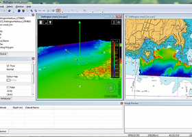 [ Zoom screenshot ] |
|
| Software Info | |
|
Best Vista Download periodically updates pricing and software information of CARIS Easy View full version from the publisher,
but some information may be out-of-date. You should confirm all information. Software piracy is theft, using crack, warez passwords, patches, serial numbers, registration codes, key generator, keymaker or keygen for CARIS Easy View license key is illegal and prevent future development of CARIS Easy View. Download links are directly from our mirrors or publisher's website, CARIS Easy View torrent files or shared files from rapidshare, yousendit or megaupload are not allowed! |
|
| Released: | August 27, 2015 |
| Filesize: | 106.00 MB |
| Platform: | Windows XP, Windows Vista, Windows Vista x64, Windows 7, Windows 7 x64, Windows 8, Windows 8 x64, Windows 10, Windows 10 x64 |
| Install | Instal And Uninstall |
| Add Your Review or Windows Vista Compatibility Report |
CARIS Easy View- Releases History |
| Software: | CARIS Easy View 4.2.13 |
| Date Released: | Aug 27, 2015 |
| Status: | New Release |
| Release Notes: | Consistent user experience in 2D and 3D The properties for coverages have been redesigned and apply both in 2D and 3D. A number of new options are presented including the ability to drape high resolution imagery (e.g. backscatter) over elevations in both 2D and 3D views. Also, a new user interface is provided to investigate the processing lineage of a dataset recorded in the metadata. Click to return to top of page Coordinate reference system enhancements The coordinate reference system (CRS) functionality has been augmented with EPSG CRS and transformations, such as NTv2. The user interface was upgraded with a new look and with additional capabilities. Users can now build a favourites list, see a list of recently used CRS entries, search for new entries and investigate all aspects of the selected reference system or transformation. Note that if an incorrect CRS has been selected when opening a dataset in the application, it is now possible to change the CRS in the Properties window wh |
| Software: | CARIS Easy View 4.1.11 |
| Date Released: | Aug 27, 2015 |
| Status: | New Release |
| Release Notes: | Expanded support for commonly used geospatial data formats (e.g. BAG, GeoTIFF, S-57) and web services (WMS, WCS, WMTS, WTMS). Upgraded support for non-proprietary BAG format to version 1.5.2, which is the latest version provided by the Open Navigation Surface Working Group. |
Most popular data types in CAD downloads for Vista |
|
Open3DQSAR 2.24 download by Paolo Tosco
... training/test set combinations, superposition schemes, variable selection and data scrambling procedures, etc. High computational performance is attained ... and GAFF force-fields with automated assignment of atom types to the imported molecular structures · Comprehensive output, ...
type: Open Source
View Details
Download
categories: chemometric analysis, analyze MIF, pharmacophore exploration, MIF, analysis, chemometry |
 |
|
MITCalc Timing Belts Calculation 1.21 download by MITCalc
... and belts. The calculations use procedures, algorithms and data from ANSI, RMA (Rubber Manufacturers Association), ISO, DIN, ... of companies ContiTech(r) and Gates Rubber Company(r). The database of belts includes the 20 most frequently used ...
type: Shareware ($18.00)
View Details
Download
categories: Belt, toothed belt, timing belt, synchronous belt, design, strength check, ANSI/RMA IP-24, 1983, DIN 7721, DIN ISO 5296, ISO 5295, CAD, CAM, DXF, ISO, DIN |
 |
|
PlotVision 8.02.1216 download by Torro-Softworks GmbH
... of your drawing, including colours, line weights, line types, fonts etc. This means that data and information created in any CAD program can ...
type: Trialware ($140.00)
View Details
Download
categories: read drawing, print drawing, control drawing, PlotVision, HPGL, drawing |
 |
|
Gnuplot for Windows 5.2.7 download by Philipp K. Janert
... scientists and students to visualize mathematical functions and data interactively, but has grown to support many non-interactive ... active development since 1986. Gnuplot supports many types of plots in either 2D and 3D. It ...
type: Open Source
View Details
Download
categories: portable, Gnuplot, Gnu plot, utility, graph plotter, plot graph, plotter, graph |
 |
|
FilterPro Desktop 3.1.0.23446 download by Texas Instruments Inc.
... component values; and view and export filter performance data to Excel. FilterPro active filter design ... and print professional design reports containing all design data and schematics to help speed time to market. ...
type: Freeware
View Details
Download
categories: create low-pass filter, high-pass filter creator, pass-band filter, create, creator, design |
 |
|
TDSL Personal Edition Portable 1.1.1.40 download by Duncan Amplification
The TDSL (Tube Data Sheet Locator) Personal Edition provides information right on ... Advanced searching facilities help you to compare different types and make substitutes for hard to find vacuum ... on 6K will bring up all vacuum tube types starting with 6K and display them in the ...
type: Freeware
View Details
Download
categories: vacuum tube locator, find vacuum tube, vacuum tube parameter, vacuum tube, locator, parameter |
 |
|
RISAFoundation 13.0.4 download by RISA Technologies, LLC.
... you the ability to solve and optimize all types of foundation systems, including mat foundations, grade beams, ... and graphics * Constant in-stream error checking and data validation * Support for all units systems & ...
type: Demo ($1 050.00)
View Details
Download
categories: optimize foundation design, foundation analysis, analyze foundation, foundation, design, analyze |
 |
|
wxGIS 0.2.0 download by Dmitry Barishnikov
... allows you to manage and to organize multiple types of geographic information. The program has an Explorer-like ... utility and a tool for correcting the orthographic data from raster TIFF files. ...
type: Open Source
View Details
Download
categories: GIS catalog, manage geography data, geographic coordinate system, manage, catalog, geography |
 |
|
wxGIS Portable 0.4.1 download by Dmitry Barishnikov
... allows you to manage and to organize multiple types of geographic information. The program has an Explorer-like ... utility and a tool for correcting the orthographic data from raster TIFF files. ...
type: Open Source
View Details
Download
categories: GIS catalog, manage geography data, geographic coordinate system, manage, catalog, geography |
 |
|
SierraSoft Land 4.0 download by SierraSoft S.r.l.
... survey of any size carried out with various types of tools, such as total stations, GPS, laser ... drones. The entire flow of restitution of acquired data, 3D surface modeling, and section and volume calculation ...
View Details
Download
|
 |