Related Keywords
data transfer software downloadsdata recovery software downloads
data encryption software downloads
data synchronization software downloads
data backup software downloads
data protection software downloads
data management software downloads
data entry software downloads
data recovering software downloads
data burning software downloads
data safety software downloads
data analysis software downloads
data migration software downloads
data repair software downloads
data eraser software downloads
data acquisition software downloads
data security software downloads
data capture software downloads
data recording software downloads
data visualization software downloads
Top Software Keywords
autocad downloads3d cad downloads
cad downloads
drawing downloads
import downloads
design downloads
dwg downloads
pdf to dwg downloads
dxf downloads
convert pdf to dwg downloads
convert downloads
dxf to pdf downloads
dwg to pdf downloads
converter downloads
pdf to dxf downloads
dwf to dwg downloads
dwg converter downloads
dwg to jpg downloads
dwg to dxf downloads
dwg to bmp downloads
stl downloads
dxf to pcl downloads
dwg to tiff downloads
intellicad downloads
pdf to cad downloads
dwg to gif downloads
convert dwg to pdf downloads
dwg to png downloads
dwg to dwf downloads
dxf to ps downloads
Vista Download
Vista downloadVista antivirus download
Vista wallpaper download
Vista wallpapers download
Vista themes download
Vista pack download
Vista ultimate download
Vista home download
Vista basic download
Vista business download
Vista x64 download
Vista transformation download
Vista transformation pack download
Vista boot download
Vista dvd download
Vista sidebar download
Vista aero download
Vista product key download
Downloads RSS
Top Downloads
Top Rated
Navigation: Home
\ Graphic Apps
\ CAD \ Terra Excess
Terra Excess25.1217 by Terra Excess Software |

|
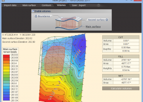
Software Description:
Terra Excess is land surveying and civil engineering software developed to be extremely intuitive. Even by those without previous experience, Terra Excess will allow you to handle the following tasks in just a few minutes - Generating and labeling contour lines in order to produce topographic plans and maps; Calculating accurate volumes of stockpiles and quarries or cut and fill volumes for Earthworks; Viewing and editing survey points. ...
type: Shareware ($298.00)
Download Terra Excesscategories: land surveying, civil engineering, topographic, contour lines, contour map, triangulated irregular network, earthworks, volumetric, volume calculation, cut and fill, volumes, estimating volumes, survey points, CAD, DXF, quarries, tin surface Add to Download Basket Report virus or spyware |
 [ Zoom screenshot ] |
|
| Software Info | |
|
Best Vista Download periodically updates pricing and software information of Terra Excess full version from the publisher,
but some information may be out-of-date. You should confirm all information. Software piracy is theft, using crack, warez passwords, patches, serial numbers, registration codes, key generator, keymaker or keygen for Terra Excess license key is illegal and prevent future development of Terra Excess. Download links are directly from our mirrors or publisher's website, Terra Excess torrent files or shared files from rapidshare, yousendit or megaupload are not allowed! |
|
| Released: | January 01, 2017 |
| Filesize: | 46.02 MB |
| Language: | English |
| Platform: | Win2000, Windows XP, Windows 7 x32, Windows 7 x64, Windows 8, Windows 10, WinServer, WinOther, Windows Vista, Windows Vista x64 |
| Requirements: | CPU:1.5 GHz or faster, RAM: 1 GB or more, Disk space: 190 MB, Active internet connection |
| Install | Install and Uninstall |
| Add Your Review or Windows Vista Compatibility Report |
Terra Excess- Releases History |
| Software: | Terra Excess 25.1217 |
| Date Released: | Jan 1, 2017 |
| Status: | New Release |
| Release Notes: | New Release |
| Software: | Terra Excess 25.1099 |
| Date Released: | Jan 1, 2017 |
| Status: | New Release |
| Release Notes: | New Release |
Most popular data transfer software in CAD downloads for Vista |
|
sRNA Workbench 4.5.1 download by UEA sRNA Workbench Team
... is a new simple to use, downloadable sRNA software package based on algorithms developed for the original ... a complete analysis of single or multiple-sample sRNA datasets from both plants and animals to identify interesting ...
View Details
Download
|
 |
|
Easy-PC 27.0 download by WestDev Ltd.
... Thus we ensure our customer’s investment in software design tools are kept up-to-date and abreast of ... systems. Just take a look at the full datasheet and you'll see what terrific value you get ...
type: Demo ($417.00)
View Details
Download
categories: create PCB schematic, circuit board designer, generate netlist, create, creator, design |
 |
|
OpenAPC 2.5 download by OpenAPC Project Group
... are specialised for different tasks. Here the ControlRoom software package covers the visualisation and process control part ... can be used to create motion and processing data for controlling e.g. XY-tables and connected tools for ...
View Details
Download
|
 |
|
Engauge Digitizer for Windows 12.0 download by Mark Mitchell
Engauge Digitizer - Digitizing software This open source, digitizing software converts an image file showing a graph or ... graph or map. The final result is digitized data that can be used by other tools such ...
type: Open Source
View Details
Download
categories: digitize image, image to number, process image, digitize, convert, digitizer |
 |
|
Terra Excess 25.1217 download by Terra Excess Software
... Excess is land surveying and civil engineering CAD software developed to be extremely intuitive. Even by those ... Excess can generate contour lines from topographic survey data in a very simple way. All you need ...
type: Shareware ($298.00)
View Details
Download
categories: land surveying, civil engineering, topographic, contour lines, contour map, triangulated irregular network, earthworks, volumetric, volume calculation, cut and fill, volumes, estimating volumes, survey points, CAD, DXF, quarries, tin surface |
 |
|
ExpertGPS 8.64 download by TopoGrafix
ExpertGPS is the ultimate mapping software for Garmin, Magellan, and Lowrance GPS owners. ExpertGPS ... from the millions of waypoints available in our database, and transfer your trip directly to your GPS ...
View Details
Download
|
 |