Related Keywords
create png image downloadscreate disk image downloads
create iso image downloads
create 3d image downloads
create dvd image downloads
create hdr image downloads
create emf image downloads
create gif image downloads
create raw image downloads
create wmf image downloads
create psd image downloads
create geometry image downloads
png image downloads
png image to pdf downloads
png image property extract downloads
png image files to tif downloads
create iso image file downloads
extract png image downloads
txt to png image downloads
text to png image downloads
Top Software Keywords
autocad downloadscad downloads
3d cad downloads
drawing downloads
import downloads
design downloads
dwg downloads
pdf to dwg downloads
dxf downloads
convert downloads
convert pdf to dwg downloads
dwg to pdf downloads
dxf to pdf downloads
converter downloads
pdf to dxf downloads
dwf to dwg downloads
dwg to dxf downloads
dwg converter downloads
dwg to jpg downloads
dwg to bmp downloads
stl downloads
dxf to pcl downloads
dwg to tiff downloads
intellicad downloads
pdf to cad downloads
dwg to gif downloads
convert dwg to pdf downloads
dwg to png downloads
dwg to dwf downloads
dxf to ps downloads
Vista Download
Vista downloadVista antivirus download
Vista wallpaper download
Vista wallpapers download
Vista themes download
Vista pack download
Vista ultimate download
Vista home download
Vista basic download
Vista business download
Vista x64 download
Vista transformation download
Vista transformation pack download
Vista boot download
Vista dvd download
Vista sidebar download
Vista aero download
Vista product key download
Downloads RSS
Top Downloads
Top Rated
Navigation: Home
\ Graphic Apps
\ CAD \ Mobile Atlas Creator
Mobile Atlas Creator2.2.1 by Fredrik Moller |

|
Software Description:
... Java based application specially designed to help you create atlases for TrekBuddy. Basically this software will create offline atlases for GPS handhelds and cell phone applications like TrekBuddy, AndNav and other Android and WindowsCE based applications. ...
Download Mobile Atlas CreatorAdd to Download Basket Report virus or spyware |
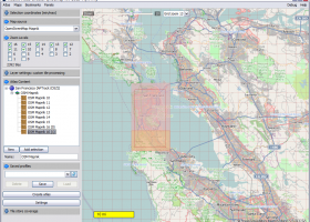 [ Zoom screenshot ] |
|
| Software Info | |
|
Best Vista Download periodically updates pricing and software information of Mobile Atlas Creator full version from the publisher,
but some information may be out-of-date. You should confirm all information. Software piracy is theft, using crack, warez passwords, patches, serial numbers, registration codes, key generator, keymaker or keygen for Mobile Atlas Creator license key is illegal and prevent future development of Mobile Atlas Creator. Download links are directly from our mirrors or publisher's website, Mobile Atlas Creator torrent files or shared files from rapidshare, yousendit or megaupload are not allowed! |
|
| Released: | June 02, 2021 |
| Filesize: | 15.00 MB |
| Platform: | Windows XP, Windows Vista, Windows Vista x64, Windows 7, Windows 7 x64, Windows 8, Windows 8 x64, Windows 10, Windows 10 x64, Linux |
| Requirements: | Java 8 or higher |
| Install | Instal And Uninstall |
| Add Your Review or Windows Vista Compatibility Report |
Mobile Atlas Creator- Releases History |
| Software: | Mobile Atlas Creator 2.2.1 |
| Date Released: | Jun 2, 2021 |
| Status: | New Release |
| Software: | Mobile Atlas Creator 2.1.3 Rev 24 |
| Date Released: | Apr 14, 2020 |
| Status: | New Release |
| Release Notes: | Minimum supported Java version increased to Java 8 (1.8) "mapFile must not be null" error when creating an atlas Save settings to settings.xml in UTF-8 format (fix for #324) Map creation error with JPEG (Garmin Custom and others) (fix for #326) |
| Software: | Mobile Atlas Creator 2.1.2 Rev 24 |
| Date Released: | Oct 11, 2019 |
| Status: | New Release |
| Release Notes: | Minimum supported Java version increased to Java 8 (1.8) "mapFile must not be null" error when creating an atlas Save settings to settings.xml in UTF-8 format (fix for #324) Map creation error with JPEG (Garmin Custom and others) (fix for #326) |
Most popular create png image in CAD downloads for Vista |
|
Easy CAD Viewer 3.3 download by Benzsoft
... viewer; it converts DWG, DXF, DWF drawings to image formats such as BMP, JPG, GIF, PNG, TIFF, and TGA. You also can access Easy ... the other formats among DXF, DWG, DWF · Create vector-based and full-text searchable PDF and SVG files ...
type: Shareware ($69.00)
View Details
Download
categories: dwg, viewer, view, read, dxf, reader, dwf, color, render, open, review, pan, zoom, layer, control, rotate, design, convert, converter, conversion, shx, font, plot, plotter, print, printer, printing, annotate, autocad, cad, export, jpg, jpeg, tif, tiff, png, bmp, tga, gif, draw, drawing |
 |
|
PlanEasy2D 1.11 download by PlanAndVisualize
... floor and supports zoom,pan operations. Features Create realistic architectural plans and specify dimensions in ft/inches or meters. Create multiple floors and draw individual plan in each ... the furniture or text. Export the plan as png, jpg, pdf or one of the other common ...
View Details
Download
|
 |
|
Gerbview x64 10.21 download by Software Companions
... and convert your Gerber, Excellon and HPGL files. Create layered PDF, DXF and DWF files from your ... files can be set individually. TIFF, CALS, BMP, PNG and JPEG files can be added to a ...
type: Trialware ($80.00)
View Details
Download
categories: x64 print Gerber image, view plot x64, convert Gerber x64, convert x64, Gerber x64, print x64 |
 |
|
PotterDraw 1.0.02.000 download by CKCI
... oscillators, and the modulations can be animated to create shape-morphing videos. The texture can be synthesized from ... color palette using various patterns, or a user-specified image file can be texture-mapped via trigonometric functions. Export ...
type: Freeware
View Details
Download
categories: CAD, 3D design, 3D printing, 3D graphics, 3D animation, pottery, ceramics, texture mapping, mesh generation, visualization, simulation |
 |
|
DataScene Deluxe 3.2.3.9 download by CyberWit, Inc.
... fitting curves, and more). The application can also create graph animations for presentations, classes, and web pages, ... graphical elements: transparent color, solid brush, gradient brush, image brush, hatch brush with 56 textures, shadow, visual ...
type: Trialware ($219.00)
View Details
Download
categories: plot 2d graph, plot 3d graph, plot mathematical graph, plot, graph, mathematical |
 |
|
TinyCAD 3.00.04 download by Tinycad.sourceforge.net
... into a Word document or saving as a PNG bitmap for the web. You can use ... of PCB layout program, by getting TinyCAD to create a netlist of your circuit. TinyCAD is ...
type: Open Source
View Details
Download
categories: JPEG, PNG, BMP or EMF, geometry editor, Constructive, Geometry, Tiny CAD |
 |
|
Mobile Atlas Creator 2.2.1 download by Fredrik Moller
... Creator) is an open source (GPL) program which creates offline atlases for GPS handhelds and cell phone ... individual maps can be exported as one large PNG image with calibration MAP file for OziExplorer. As ...
View Details
Download
|
 |
|
Raylectron 4.17 download by SoftByte Labs.
... Photoshop) to produce photorealistic renders. You can virtually create rendered images of any size. There is also 4 types ... glossiness, shininess, bump maps, normal maps and background images. Create you own grass and fur. Caustics are ...
type: Shareware ($199.95)
View Details
Download
categories: sketchup, render, renderer, rendering, plugin, animation, 3D model, photorealistic, photo-realistic, trimble, google, raytrace, ray, lectron, electron |
 |
|
TNTmips 20240404 download by MicroImages, Inc.
... with virtually any type of geospatial data including imagery, terrain surfaces, and map data with associated database ... provides all the tools you need to view, create, edit, georeference, interpret, and publish any type of ...
type: Freeware
View Details
Download
categories: GIS data analysis, analyze geodetic data, edit GIS dataset, GIS, dataset, editor, analysis |
 |
|
HighDesign 2023.1.1.2184.0 download by ILEXSOFT
... full-featured, fast CAD and architectural design solution to create precise drawings, projects, layouts, and work with DWG ... scaled and perspective-correct elevations from a single picture; image editing functions; a drawing presentation tool to generate ...
type: Shareware ($449.00)
View Details
Download
categories: CAD, BIM, drafting, drawing, project, architecture, engineering, construction, mechanical, dxf, dwg, pdf, vector, design, autocad, plans, remodel, floorplan, blueprint, draught, layout, technical, sketch |
 |