Related Keywords
create elevation map downloadscreate site map downloads
create image map downloads
create mind map downloads
create topographic map downloads
create normal map downloads
create contour map downloads
x64 create contour map downloads
create map downloads
elevation downloads
elevation view symbols downloads
map downloads
map drive downloads
map component downloads
map engine downloads
map network drive downloads
map serial port downloads
map files downloads
map open ports to process downloads
map point downloads
Top Software Keywords
autocad downloads3d cad downloads
cad downloads
drawing downloads
import downloads
design downloads
dwg downloads
pdf to dwg downloads
dxf downloads
convert downloads
convert pdf to dwg downloads
dwg to pdf downloads
dxf to pdf downloads
converter downloads
pdf to dxf downloads
dwf to dwg downloads
dwg to dxf downloads
dwg converter downloads
dwg to jpg downloads
dwg to bmp downloads
stl downloads
dxf to pcl downloads
dwg to tiff downloads
intellicad downloads
pdf to cad downloads
dwg to gif downloads
convert dwg to pdf downloads
dwg to png downloads
dwg to dwf downloads
dxf to ps downloads
Vista Download
Vista downloadVista antivirus download
Vista wallpaper download
Vista wallpapers download
Vista themes download
Vista pack download
Vista ultimate download
Vista home download
Vista basic download
Vista business download
Vista x64 download
Vista transformation download
Vista transformation pack download
Vista boot download
Vista dvd download
Vista sidebar download
Vista aero download
Vista product key download
Downloads RSS
Top Downloads
Top Rated
Navigation: Home
\ Graphic Apps
\ CAD \ Terra Excess
Terra Excess25.1217 by Terra Excess Software |

|
Software Description:
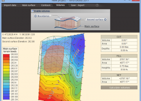
Terra Excess is land surveying and civil engineering software developed to be extremely intuitive. Even by those without previous experience, Terra Excess will allow you to handle the following tasks in just a few minutes - Generating and labeling contour lines in order to produce topographic plans and maps; Calculating accurate volumes of stockpiles and quarries or cut and fill volumes for Earthworks; Viewing and editing survey points. ...
type: Shareware ($298.00)
Download Terra Excesscategories: land surveying, civil engineering, topographic, contour lines, contour map, triangulated irregular network, earthworks, volumetric, volume calculation, cut and fill, volumes, estimating volumes, survey points, CAD, DXF, quarries, tin surface Add to Download Basket Report virus or spyware |
 [ Zoom screenshot ] |
|
| Software Info | |
|
Best Vista Download periodically updates pricing and software information of Terra Excess full version from the publisher,
but some information may be out-of-date. You should confirm all information. Software piracy is theft, using crack, warez passwords, patches, serial numbers, registration codes, key generator, keymaker or keygen for Terra Excess license key is illegal and prevent future development of Terra Excess. Download links are directly from our mirrors or publisher's website, Terra Excess torrent files or shared files from rapidshare, yousendit or megaupload are not allowed! |
|
| Released: | January 01, 2017 |
| Filesize: | 46.02 MB |
| Language: | English |
| Platform: | Win2000, Windows XP, Windows 7 x32, Windows 7 x64, Windows 8, Windows 10, WinServer, WinOther, Windows Vista, Windows Vista x64 |
| Requirements: | CPU:1.5 GHz or faster, RAM: 1 GB or more, Disk space: 190 MB, Active internet connection |
| Install | Install and Uninstall |
| Add Your Review or Windows Vista Compatibility Report |
Terra Excess- Releases History |
| Software: | Terra Excess 25.1217 |
| Date Released: | Jan 1, 2017 |
| Status: | New Release |
| Release Notes: | New Release |
| Software: | Terra Excess 25.1099 |
| Date Released: | Jan 1, 2017 |
| Status: | New Release |
| Release Notes: | New Release |
Most popular create elevation map in CAD downloads for Vista |
|
TNTmips 20240404 download by MicroImages, Inc.
... of geospatial data including imagery, terrain surfaces, and map data with associated database attributes. It provides all the tools you need to view, create, edit, georeference, interpret, and publish any type of ...
type: Freeware
View Details
Download
categories: GIS data analysis, analyze geodetic data, edit GIS dataset, GIS, dataset, editor, analysis |
 |
|
QGIS 3.36.1 download by Gary Sherman
... and database formats and lets you browse and create map data on your computer. QGIS supports many ... On the fly projection of vector layers · Map composer · Identify features · Display attribute table ...
type: Open Source
View Details
Download
categories: geographic information system, map creator, map viewer, GIS, geographic information, create, QGIS |
 |
|
Terra Excess 25.1217 download by Terra Excess Software
... need to do is select the points with elevation values and create a 'Main surface'. Once done, you should choose ... Generated contours can be used as a base map for designing and implementing various construction projects or ...
type: Shareware ($298.00)
View Details
Download
categories: land surveying, civil engineering, topographic, contour lines, contour map, triangulated irregular network, earthworks, volumetric, volume calculation, cut and fill, volumes, estimating volumes, survey points, CAD, DXF, quarries, tin surface |
 |