Related Keywords
contour downloadscontour map downloads
contour tracking downloads
contour plotting downloads
contour plot excel downloads
contour processor downloads
contour lines downloads
contour plot downloads
contour cutting downloads
contour mapping downloads
3d 4d map contour isosurface downloads
x64 contour map downloads
color filled contour map downloads
x64 create contour map downloads
2d contour scanner downloads
color filled contour maps downloads
create contour map downloads
Top Software Keywords
autocad downloads3d cad downloads
cad downloads
drawing downloads
import downloads
design downloads
dwg downloads
pdf to dwg downloads
convert pdf to dwg downloads
dxf downloads
convert downloads
dxf to pdf downloads
dwg to pdf downloads
converter downloads
pdf to dxf downloads
dwf to dwg downloads
dwg converter downloads
dwg to jpg downloads
dwg to dxf downloads
dwg to bmp downloads
stl downloads
dxf to pcl downloads
dwg to tiff downloads
intellicad downloads
pdf to cad downloads
dwg to gif downloads
convert dwg to pdf downloads
dwg to png downloads
dwg to dwf downloads
dxf to ps downloads
Vista Download
Vista downloadVista antivirus download
Vista wallpaper download
Vista wallpapers download
Vista themes download
Vista pack download
Vista ultimate download
Vista home download
Vista basic download
Vista business download
Vista x64 download
Vista transformation download
Vista transformation pack download
Vista boot download
Vista dvd download
Vista sidebar download
Vista aero download
Vista product key download
Downloads RSS
Top Downloads
Top Rated
Navigation: Home
\ Graphic Apps
\ CAD \ LanDTM
LanDTM6.1 by Aplicaciones Topográficas S.L. |

|
Software Description:
There is not any professional program on internet like this and you can get it without any effort. I think this could be a handicap because it's dificult to believe, but it's true; try it and you'll be surprised. It's not only a program to calculate a delaunay triangulation but you can input break-lines to get a real representation of the terrain. ...
type: Freeware
Download LanDTMcategories: Delaunay triangulation, Terrain Representation, CAD addon, Delaunay triangulation, Calculate, Terrain Add to Download Basket Report virus or spyware |
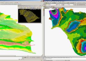 [ Zoom screenshot ] |
|
| Software Info | |
|
Best Vista Download periodically updates pricing and software information of LanDTM full version from the publisher,
but some information may be out-of-date. You should confirm all information. Software piracy is theft, using crack, warez passwords, patches, serial numbers, registration codes, key generator, keymaker or keygen for LanDTM license key is illegal and prevent future development of LanDTM. Download links are directly from our mirrors or publisher's website, LanDTM torrent files or shared files from rapidshare, yousendit or megaupload are not allowed! |
|
| Released: | April 23, 2017 |
| Filesize: | 58.80 MB |
| Platform: | Windows XP, Windows Vista, Windows Vista x64, Windows 7, Windows 7 x64, Windows 8, Windows 8 x64, Windows 10, Windows 10 x64 |
| Install | Instal And Uninstall |
| Add Your Review or Windows Vista Compatibility Report |
LanDTM- Releases History |
| Software: | LanDTM 6.1 |
| Date Released: | Apr 23, 2017 |
| Status: | New Release |
| Software: | LanDTM 6.1.6 |
| Date Released: | Feb 16, 2012 |
| Status: | New Release |
| Release Notes: | · New installers of the program to 32 and 64 bits platforms. · LanDTM on BricsCAD v12. · LanDTM on Autocad 2012. · Separator/discriminator of points. · Compatibility with "gsf" grid files REDNAP of Geoid ondulation. · Elevation modification of PPuntos. · Importation/exportationn of Points to PPuntos. · Compatibility between formats. Trimble M3, GPS Trimble, GSI of Stonex. |
| Software: | LanDTM 6.1.5 |
| Date Released: | Oct 5, 2011 |
| Status: | New Release |
| Release Notes: | · You can digitalize lines and points in Google Earth and export them to the CAD. It Works in BricsCAD v11. |
Most popular contour in CAD downloads for Vista |
|
Kst 2.0.8 download by Barth Netterfield
... equations, and power spectra. · Color mapping and contour mapping capabilities for three-dimensional data, as well as matrix and image support. · Monitoring of events and notifications support. · Built-in ...
type: Open Source
View Details
Download
categories: view large-datasets, dataset viewer, plot dataset, view, plotter, viewer |
|
ContourTrace 2022 2.3.1.0 download by KUHN SOLUTIONS
ContourTrace enables an easy, fast and convenient extraction of contours from images. The extraction of the contours is made possible by applying different filters and algorithms to the input image. The extracted contours can be exported into the DXF and SVG ...
type: Shareware ($19.00)
View Details
Download
categories: Image Vectorizer, Image to DXF ans SVG converter, Image to DXF, Image, DXF, Picture, Contour, Converter, 2D Scan, 2D Contour Scanner, CAD, DXF format |
 |
|
TopoLT 15.2 download by CADWARE Engineering
... digital format, who develop 3D terrain models and contours, fill and cut volumes calculation, raster image georeferencing ... points; · 3D model of the terrain and contour lines can be generated, volumes can be calculated ...
type: Trialware ($600.00)
View Details
Download
categories: topographical plan, cadastral plan, terrain model, topography, cadaster, terrain |
 |
|
LanDTM 6.1 download by Aplicaciones Topográficas S.L.
... possibility to include break-lines and to draw the contour lines without smoothing or with a reliable smoothing ... and too, you can add labels on the contour lines. So, the program is the mother ...
type: Freeware
View Details
Download
categories: Delaunay triangulation, Terrain Representation, CAD addon, Delaunay triangulation, Calculate, Terrain |
 |
|
Terra Excess 25.1217 download by Terra Excess Software
... just a few minutes - GENERATING AND LABELING CONTOUR LINES IN ORDER TO PRODUCE TOPOGRAPHIC PLANS AND MAPS: Terra Excess can generate contour lines from topographic survey data in a very ...
type: Shareware ($298.00)
View Details
Download
categories: land surveying, civil engineering, topographic, contour lines, contour map, triangulated irregular network, earthworks, volumetric, volume calculation, cut and fill, volumes, estimating volumes, survey points, CAD, DXF, quarries, tin surface |
 |
|
OutlineArt 1.9.2 download by DWG TOOL Software
... ratio(DXF only) . Setting up smoothness of vector contour . Saving inputted words to txt file for future use . Saving to DXF file . Easy in use. ...
type: Shareware ($29.95)
View Details
Download
categories: ttf to dxf, vector, symbol, dxf, convert, font, cad text editor, cad, arx |
 |
|
CurveExpert Professional 2.7.3 download by Daniel G. Hyams
... the purposes of 3D plotting, scatterplots, surfaces, and contour plots are supported. Graph themes allow you to customize a look that you prefer, and reuse it. Graphs are interactive, with ...
View Details
Download
|
 |
|
Origin 10.5.70 download by OriginLab Corp.
... quality graphs to suit your needs. Many popular contour, 2D, and 3D graph types are supported, as are specialty graphs such as windrose, stock (OHLC), ternary (including ternary-contour), 2D vector ...
type: Trialware ($69.00)
View Details
Download
categories: Create Graph, Create Plot, Vector Analysis, Graph, Vector, Statistics |
 |
|
Multiwfn 3.7 download by sobereva
... plotting graph. Supported graph types including filled-color map, contour map, relief map (with/without projection), gradient map, vector field map. · Outputting properties in a spatial scope, data can be exported ...
type: Open Source
View Details
Download
categories: wavefunction analysis, topology analysis, molecular structure, analysis, analize, wavefunction |
 |
|
Maxsurf 17.07 download by Bentley Systems
... as well as curvature along a particular surface contour such as a waterline or diagonal. Curvature displays are automatically and interactively updated as you modify the surface. All Maxsurf designs ...
View Details
Download
|
 |