Related Keywords
contour lines downloadscontour downloads
contour map downloads
contour tracking downloads
contour plotting downloads
contour plot excel downloads
contour processor downloads
contour plot downloads
contour cutting downloads
contour mapping downloads
lines downloads
lines on hold downloads
lines game downloads
lines deluxe downloads
lines 3d cool puzzle logical downloads
lines pack downloads
lines standard includes a downloads
lines games downloads
lines 2007 downloads
lines of code downloads
Top Software Keywords
autocad downloads3d cad downloads
cad downloads
drawing downloads
import downloads
design downloads
dwg downloads
pdf to dwg downloads
convert pdf to dwg downloads
dxf downloads
convert downloads
dxf to pdf downloads
dwg to pdf downloads
converter downloads
pdf to dxf downloads
dwf to dwg downloads
dwg converter downloads
dwg to jpg downloads
dwg to dxf downloads
dwg to bmp downloads
stl downloads
dxf to pcl downloads
dwg to tiff downloads
intellicad downloads
pdf to cad downloads
dwg to gif downloads
convert dwg to pdf downloads
dwg to png downloads
dwg to dwf downloads
dxf to ps downloads
Vista Download
Vista downloadVista antivirus download
Vista wallpaper download
Vista wallpapers download
Vista themes download
Vista pack download
Vista ultimate download
Vista home download
Vista basic download
Vista business download
Vista x64 download
Vista transformation download
Vista transformation pack download
Vista boot download
Vista dvd download
Vista sidebar download
Vista aero download
Vista product key download
Downloads RSS
Top Downloads
Top Rated
Navigation: Home
\ Graphic Apps
\ CAD \ RTOPO Hydrology
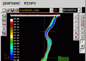
RTOPO Hydrology3.4 by Rcad Software |

|
Software Description:
... for surveying. You can do triangulation, isolines, color-filled contour maps, sections, intersections, volume, editing XYZ files, simulation of rainwater runoff and much more. You can represent 4D points cloud and process hundreds of thousands of points or triangles, even on less powerful PCs. ...
type: Shareware ($125.00)
Download RTOPO Hydrologycategories: CAD for Topography, XYZ File editor, hydrology, LandXML, Triangulation, Isolines, Cross sections, Longitudinal profile, Intersection of two triangulations, quartic triangular patches Buy Now Add to Download Basket Report virus or spyware |
 [ Zoom screenshot ] |
|
| Software Info | |
|
Best Vista Download periodically updates pricing and software information of RTOPO Hydrology full version from the publisher,
but some information may be out-of-date. You should confirm all information. Software piracy is theft, using crack, warez passwords, patches, serial numbers, registration codes, key generator, keymaker or keygen for RTOPO Hydrology license key is illegal and prevent future development of RTOPO Hydrology. Download links are directly from our mirrors or publisher's website, RTOPO Hydrology torrent files or shared files from rapidshare, yousendit or megaupload are not allowed! |
|
| Website: | Rcad Software - RTOPO Hydrology homepage |
| Released: | July 09, 2023 |
| Filesize: | 2.48 MB |
| Language: | English |
| Platform: | Win2000, Windows XP, Windows 7 x32, Windows 7 x64, Windows 8, Windows 10, WinServer, WinOther, Windows Vista, Windows Vista x64 |
| Requirements: | Graphic card with OpenGL hardware acceleration and 32-bit color depth |
| Install | Install and Uninstall |
| Add Your Review or Windows Vista Compatibility Report |
RTOPO Hydrology- Releases History |
| Software: | RTOPO Hydrology 3.4 |
| Date Released: | Jul 9, 2023 |
| Status: | New Release |
| Release Notes: | It can simulate rainwater runoff. |
| Software: | RTOPO Hydrology 3.3 |
| Date Released: | Sep 26, 2020 |
| Status: | New Release |
| Release Notes: | It can be purchased with a 1-year subscription. |
| Software: | RTOPO Hydrology 3.3d |
| Date Released: | Sep 26, 2020 |
| Status: | New Release |
| Release Notes: | It can be purchased with a 1-year subscription. |
Most popular contour lines in CAD downloads for Vista |
|
TopoLT 15.2 download by CADWARE Engineering
... digital format, who develop 3D terrain models and contours, fill and cut volumes calculation, raster image georeferencing ... points; · 3D model of the terrain and contour lines can be generated, volumes can be calculated ...
type: Trialware ($600.00)
View Details
Download
categories: topographical plan, cadastral plan, terrain model, topography, cadaster, terrain |
 |
|
RTOPO Hydrology 3.4 download by Rcad Software
... for surveying. You can do triangulation, isolines, color-filled contour maps, sections, intersections, volume and much more. You ... on a convex hull or between an external contour and possibly more interior contours -contour lines and ...
type: Shareware ($125.00)
View Details
Download
categories: CAD for Topography, XYZ File editor, hydrology, LandXML, Triangulation, Isolines, Cross sections, Longitudinal profile, Intersection of two triangulations, quartic triangular patches |
 |
|
LanDTM 6.1 download by Aplicaciones Topográficas S.L.
... possibility to include break-lines and to draw the contour lines without smoothing or with a reliable smoothing algorithm and too, you can add labels on the contour lines. So, the program is the mother ...
type: Freeware
View Details
Download
categories: Delaunay triangulation, Terrain Representation, CAD addon, Delaunay triangulation, Calculate, Terrain |
 |
|
Maxsurf 17.07 download by Bentley Systems
... parametric transformation · Extract key design data via lines, offsets, hydrostatic properties or curve of areas ... as well as curvature along a particular surface contour such as a waterline or diagonal. Curvature displays ...
View Details
Download
|
 |
|
JMARS for Windows 3.1.5 download by Arizona State University
... surface roughness data with thermal inertia data. * Contour maps may be created. * Groups of layers ... * Plots may be created by drawing multi-segment lines on the map, making it easy to sample ...
type: Freeware
View Details
Download
categories: mission analysis, geospatial information, GIS analysis, mission, analysis, GIS |
 |
|
TNTmips 20240404 download by MicroImages, Inc.
... from 3D information. Fast and efficient Surface Fitting, Contouring, and Triangulation operations produce Digital Elevation Model rasters (DEMs), contour lines, and triangulated irregular networks (TINs), respectively ... ...
type: Freeware
View Details
Download
categories: GIS data analysis, analyze geodetic data, edit GIS dataset, GIS, dataset, editor, analysis |
 |
|
Terra Excess 25.1217 download by Terra Excess Software
... just a few minutes - GENERATING AND LABELING CONTOUR LINES IN ORDER TO PRODUCE TOPOGRAPHIC PLANS AND MAPS: Terra Excess can generate contour lines from topographic survey data in a very ...
type: Shareware ($298.00)
View Details
Download
categories: land surveying, civil engineering, topographic, contour lines, contour map, triangulated irregular network, earthworks, volumetric, volume calculation, cut and fill, volumes, estimating volumes, survey points, CAD, DXF, quarries, tin surface |
 |
|
Maxsurf 17.07 download by Bentley Systems
... parametric transformation · Extract key design data via lines, offsets, hydrostatic properties or curve of areas ... as well as curvature along a particular surface contour such as a waterline or diagonal. Curvature displays ...
View Details
Download
|
|