Related Keywords
calculation downloadscalculation engine downloads
calculation time zone downloads
calculation component downloads
calculation solitaire downloads
calculation recorder downloads
calculation of excise duty downloads
calculation program downloads
calculation machine downloads
calculation of food value downloads
calculation documenting tool downloads
calculation software downloads
calculation commenter downloads
beam calculation downloads
bolt calculation downloads
expression calculation downloads
traffic calculation downloads
volume calculation downloads
nutrition calculation downloads
purple star calculation downloads
Top Software Keywords
odbc downloadsdatabase downloads
sql downloads
data downloads
excel downloads
access downloads
table downloads
tool downloads
dbf downloads
oracle downloads
export downloads
mysql downloads
microsoft downloads
sql server downloads
server downloads
csv downloads
gui downloads
import downloads
query downloads
management downloads
convert downloads
development downloads
conversion downloads
utility downloads
tables downloads
dictionary downloads
migrate downloads
vista transformation downloads
ems downloads
sqlmanager downloads
Vista Download
Vista downloadVista antivirus download
Vista wallpaper download
Vista wallpapers download
Vista themes download
Vista pack download
Vista ultimate download
Vista home download
Vista basic download
Vista business download
Vista x64 download
Vista transformation download
Vista transformation pack download
Vista boot download
Vista dvd download
Vista sidebar download
Vista aero download
Vista product key download
Downloads RSS
Top Downloads
Top Rated
Navigation: Home
\ Business
\ Databases & Tools \ ORTWIN
ORTWIN17.03 by Killet GeoSoftware Ing.-GbR |

|
Software Description:
... administrative units. It performs perimeter searches and distance calculations. It finds landscapes, natural units and snow- and wind load zones. ...
type: Shareware ($125.00)
Download ORTWINcategories: local, index, register, place, locality, town, city, cities, quarter, geo, coding, periphery, perimeter, search, distance, municipality, district, coordinate, coordinates, elevation, longitude, latitude, snow load, wind load, landscape, center, distance, transformation Add to Download Basket Report virus or spyware |
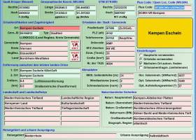 [ Zoom screenshot ] |
|
| Software Info | |
|
Best Vista Download periodically updates pricing and software information of ORTWIN full version from the publisher,
but some information may be out-of-date. You should confirm all information. Software piracy is theft, using crack, warez passwords, patches, serial numbers, registration codes, key generator, keymaker or keygen for ORTWIN license key is illegal and prevent future development of ORTWIN. Download links are directly from our mirrors or publisher's website, ORTWIN torrent files or shared files from rapidshare, yousendit or megaupload are not allowed! |
|
| Released: | June 18, 2021 |
| Filesize: | 4.75 MB |
| Language: | English, German |
| Platform: | Win2000, Windows XP, Windows 7 x32, Windows 7 x64, Windows 8, Windows 10, WinServer, WinOther, Windows Vista, Windows Vista x64 |
| Requirements: | Pentium, 50 MB HD |
| Install | Install and Uninstall |
| Add Your Review or Windows Vista Compatibility Report |
ORTWIN- Releases History |
| Software: | ORTWIN 17.03 |
| Date Released: | Jun 18, 2021 |
| Status: | Major Update |
| Release Notes: | Program is faster and more stable using a new development system. All databases actualized on 1st. January 2021. Territorial Reform in Thuringia of the year 2019 implemented. View of localities in OpenStreetMap, Google Maps, Google Earth. Determining the wind load zones and snow load zones. |
| Software: | ORTWIN 16.02 |
| Date Released: | Nov 11, 2020 |
| Status: | Major Update |
| Release Notes: | All databases actualized on 1st. January 2019. Territorial Reform in Thuringia from 1.1.2019 taken into account. View of localities in OpenStreetMap, Google Maps, Google Earth. ORTWIN decorated with Innovation Award. Wind load zones and snow load zones. Travel areas and the solar radiation. |
| Software: | ORTWIN 16.00 |
| Date Released: | Dec 30, 2019 |
| Status: | Major Update |
| Release Notes: | All databases actualized on 1st. January 2019. Territorial Reform in Thuringia from 1.1.2019 taken into account. View of localities in OpenStreetMap, Google Maps, Google Earth. ORTWIN decorated with Innovation Award. Wind load zones and snow load zones. Travel areas and the solar radiation. |
Most popular calculation in Databases & Tools downloads for Vista |
|
ORTWIN 17.03 download by Killet GeoSoftware Ing.-GbR
... domicile. The program performs perimeter searches and distance calculations. It finds landscapes on different levels, natural units ... conversions between different coordinate systems and the distance calculation between the places. It calculates with Gauss Krueger ...
type: Shareware ($125.00)
View Details
Download
categories: local, index, register, place, locality, town, city, cities, quarter, geo, coding, periphery, perimeter, search, distance, municipality, district, coordinate, coordinates, elevation, longitude, latitude, snow load, wind load, landscape, center, distance, transformation |
 |
|
Quick Maintenance and Backup for MS SQL 1.4.2.0 download by SoftLab LLC
... gathering statistics on the size of the database calculation of average data growth - maintains several SQL Servers in one program QMB maintains databases on the 2000-2014 versions of any ...
type: Shareware ($39.00)
View Details
Download
categories: sql server backup database, sql server express backup, sql server backup software, sql server index maintenance, integrity check sql server, sql server best practices, sql maintenance plan, sql scheduler, sql server disk space |
 |
|
Geodata International 13.03 download by Killet GeoSoftware Ing.-GbR
... and elevations for geocoding, proximity search, navigation, distance calculation. Often is it necessarily, for an address characteristic, e.g. the place name or the postal code, to establish a local relationship ...
type: Data Only ($165.00)
View Details
Download
categories: geo, data, geodata, point, pointdata, spatial, reference, coding, coordinates, places, local, localities, town, quarters, postal, zip, code, periphery, search, distance, calculation, elevation, list, listing, municipality, database, longitude, latitude, geographic, utm, wgs84 |
 |