Related Keywords
analyze map downloadsanalyze downloads
analyze registry downloads
analyze time downloads
analyze http downloads
analyze links downloads
analyze google adwords downloads
analyze trades downloads
analyze game performance downloads
analyze data downloads
analyze keywords downloads
analyze the source code downloads
analyze report downloads
analyze reports downloads
analyze disk space downloads
analyze file downloads
analyze web usage downloads
analyze performance downloads
analyze disk downloads
analyze isa logs downloads
Top Software Keywords
autocad downloads3d cad downloads
cad downloads
drawing downloads
import downloads
design downloads
dwg downloads
pdf to dwg downloads
dxf downloads
convert downloads
convert pdf to dwg downloads
dwg to pdf downloads
dxf to pdf downloads
converter downloads
pdf to dxf downloads
dwf to dwg downloads
dwg converter downloads
dwg to dxf downloads
dwg to jpg downloads
dwg to bmp downloads
stl downloads
dxf to pcl downloads
dwg to tiff downloads
intellicad downloads
pdf to cad downloads
dwg to gif downloads
convert dwg to pdf downloads
dwg to png downloads
dwg to dwf downloads
dxf to ps downloads
Vista Download
Vista downloadVista antivirus download
Vista wallpaper download
Vista wallpapers download
Vista themes download
Vista pack download
Vista ultimate download
Vista home download
Vista basic download
Vista business download
Vista x64 download
Vista transformation download
Vista transformation pack download
Vista boot download
Vista dvd download
Vista sidebar download
Vista aero download
Vista product key download
Downloads RSS
Top Downloads
Top Rated
Navigation: Home
\ Graphic Apps
\ CAD \ UCL Depthmap
UCL Depthmap0.8.0 by University College London |

|
Software Description:
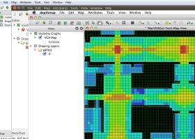
Depthmap is a single software platform to perform a set of spatial network analyses designed to understand social processes within the built environment. It works at a variety of scales from building through small urban to whole cities or states. ...
type: Open Source
Download UCL Depthmapcategories: urban environment, urban map, spatial network analysis, environment, map, analysis Add to Download Basket Report virus or spyware |
 [ Zoom screenshot ] |
|
| Software Info | |
|
Best Vista Download periodically updates pricing and software information of UCL Depthmap full version from the publisher,
but some information may be out-of-date. You should confirm all information. Software piracy is theft, using crack, warez passwords, patches, serial numbers, registration codes, key generator, keymaker or keygen for UCL Depthmap license key is illegal and prevent future development of UCL Depthmap. Download links are directly from our mirrors or publisher's website, UCL Depthmap torrent files or shared files from rapidshare, yousendit or megaupload are not allowed! |
|
| Released: | November 08, 2020 |
| Filesize: | 35.10 MB |
| Platform: | Windows XP, Windows Vista, Windows Vista x64, Windows 7, Windows 7 x64, Windows 8, Windows 8 x64, Windows 10, Windows 10 x64, Windows 11 |
| Install | Instal And Uninstall |
| Add Your Review or Windows Vista Compatibility Report |
UCL Depthmap- Releases History |
| Software: | UCL Depthmap 0.8.0 |
| Date Released: | Nov 8, 2020 |
| Status: | New Release |
| Release Notes: | General: Allow for pushing values from shapemaps (axial maps, segment maps) to VGA Fix VGA map connections export Make drawing to segment conversion faster Test and fix shape removal for axial and data maps Allow pushing the Ref or Key value to another layer Fix MIF/MID import (allow for empty columns, PR #369) Fix diagonal line handling on VGA map fill (PR #326, thanks Piotr Piastucki!) Change C++ standard to 17 Graphical User Interface (GUI): Highlight shapes and pixels on hover (can be disabled in the settings) Allow inserting any number in the table (PR #356) Fix a case where the app would crash with multiple unlinking in VGA (PR #328) Fix convex map hover and selection (PR #368) Allow generating multiple isovists by importing a CSV file Fix a case where VGA progress bar would end, but analysis would still be going (PR #323) |
| Software: | UCL Depthmap 0.7.0 |
| Date Released: | Jun 7, 2019 |
| Status: | New Release |
| Software: | UCL Depthmap 0.30 |
| Date Released: | Sep 18, 2014 |
| Status: | New Release |
Most popular analyze map in CAD downloads for Vista |
|
UCL Depthmap 0.8.0 download by University College London
... aim of the software is to produce a map of open space elements, connect them via some ... Depthmap can be used to derive an ‘axial map’ of a layout. That is, derive a reduced ...
type: Open Source
View Details
Download
categories: urban environment, urban map, spatial network analysis, environment, map, analysis |
 |
|
Thuban for Windows 1.2.2 download by Thuban Development Team
... viewer) which features methods to visualize, explore, and analyze geographic information. Thuban is an Interactive Geographic ... Data Support: GeoTIFF Layer and GDAL # Comfortable Map Navigation # Object Identification and Annotation # Legend ...
type: Open Source
View Details
Download
categories: geographic data viewer, gis viewer, analyze geographic information, information, geographic, viewer |
 |
|
Panoply 5.4.3 download by Robert B. Schmunk
... comprehensive software application that helps you plot and analyze raster images of geo-gridded data from NetCDF and ... Plot lon-lat data on a global or regional map (using any of over 75 map projections) or ...
type: Freeware
View Details
Download
categories: plot raster image, longitude image, pole-to-pole image, raster image, rasterize, raster |
 |
|
CARIS Easy View 4.2.13 download by CARIS
... a wide range file types, enabling you to analyze raster and vector data saved to numerous formats. ... application that can be used to view and analyze spatial data. It is easy-to-use and includes extensive ...
View Details
Download
|
 |
|
TNTmips 20240404 download by MicroImages, Inc.
... of geospatial data including imagery, terrain surfaces, and map data with associated database attributes. It provides all ... published on the Internet as web tilesets, Web Map Service (WMS), and ArcIMS ... Automatically generate ...
type: Freeware
View Details
Download
categories: GIS data analysis, analyze geodetic data, edit GIS dataset, GIS, dataset, editor, analysis |
 |
|
GetNexrad 4.4.2 download by Carson
... 0.5 dBZ long range higher resolution images. Goggle Map overlays, real-time surface observations, and a web browser sidebar for even more real-time weather info. ...
type: Freeware
View Details
Download
categories: extract rainfall amount, DBZ analysis, view radar rainfall, view, extract, rainfall |
 |