Related Keywords
aerial downloadsaerial mahjong downloads
aerial antics downloads
aerial photography downloads
download aerial antics downloads
play aerial antics downloads
Top Software Keywords
autocad downloads3d cad downloads
cad downloads
drawing downloads
import downloads
design downloads
dwg downloads
pdf to dwg downloads
dxf downloads
convert pdf to dwg downloads
convert downloads
dwg to pdf downloads
dxf to pdf downloads
converter downloads
pdf to dxf downloads
dwf to dwg downloads
dwg converter downloads
dwg to jpg downloads
dwg to dxf downloads
dwg to bmp downloads
stl downloads
dxf to pcl downloads
dwg to tiff downloads
intellicad downloads
pdf to cad downloads
dwg to gif downloads
convert dwg to pdf downloads
dwg to png downloads
dwg to dwf downloads
dxf to ps downloads
Vista Download
Vista downloadVista antivirus download
Vista wallpaper download
Vista wallpapers download
Vista themes download
Vista pack download
Vista ultimate download
Vista home download
Vista basic download
Vista business download
Vista x64 download
Vista transformation download
Vista transformation pack download
Vista boot download
Vista dvd download
Vista sidebar download
Vista aero download
Vista product key download
Downloads RSS
Top Downloads
Top Rated
Navigation: Home
\ Graphic Apps
\ CAD \ ExpertGPS
ExpertGPS8.64 by TopoGrafix |

|
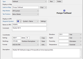
Software Description:
... routes, and tracks on USGS topo maps and aerial photos. Using the powerful mapping tools in ExpertGPS, you can draw your route directly on a map, search for nearby features from the millions of waypoints available in our database, and transfer your trip directly to your GPS in one click. ...
Download ExpertGPSAdd to Download Basket Report virus or spyware |
 [ Zoom screenshot ] |
|
| Software Info | |
|
Best Vista Download periodically updates pricing and software information of ExpertGPS full version from the publisher,
but some information may be out-of-date. You should confirm all information. Software piracy is theft, using crack, warez passwords, patches, serial numbers, registration codes, key generator, keymaker or keygen for ExpertGPS license key is illegal and prevent future development of ExpertGPS. Download links are directly from our mirrors or publisher's website, ExpertGPS torrent files or shared files from rapidshare, yousendit or megaupload are not allowed! |
|
| Released: | June 12, 2024 |
| Filesize: | 13.50 MB |
| Platform: | Windows XP, Windows Vista, Windows Vista x64, Windows 7, Windows 7 x64, Windows 8, Windows 8 x64, Windows 10, Windows 10 x64, Windows 11 |
| Install | Instal And Uninstall |
| Add Your Review or Windows Vista Compatibility Report |
ExpertGPS- Releases History |
| Software: | ExpertGPS 8.64 |
| Date Released: | Jun 12, 2024 |
| Status: | New Release |
| Software: | ExpertGPS 8.63 |
| Date Released: | Apr 15, 2024 |
| Status: | New Release |
| Software: | ExpertGPS 8.61 |
| Date Released: | Mar 12, 2024 |
| Status: | New Release |
Most popular aerial in CAD downloads for Vista |
|
Sweet Home 3D 7.4 download by Sweethome3d
... you can navigate in it either from an aerial view point, or from a virtual visitor view ... 2D, simultaneously view it in 3D from an aerial point of view, or navigate into it from ...
type: Open Source
View Details
Download
categories: interior design, interior design software, placing your furniture, free interior design software, 2D plan, 3D plan, 3D preview, free interior design, SweetHome 3D |
 |
|
ExpertGPS 8.64 download by TopoGrafix
... routes, and tracks on USGS topo maps and aerial photos. Using the powerful mapping tools in ... whole new view of the world with the aerial photos and maps in ExpertGPS. ...
View Details
Download
|
 |
|
QGIS 3.36.1 download by Gary Sherman
... Display raster data such as digital elevation models, aerial photography or landsat imagery · Change raster symbology (grayscale, pseudocolor and multiband RGB) · Export to Mapserver map file · Digitizing ...
type: Open Source
View Details
Download
categories: geographic information system, map creator, map viewer, GIS, geographic information, create, QGIS |
 |
|
X-Sweet Home 3D 4.4 [rev18] download by winPenPack
... 2D, simultaneously view it in 3D from an aerial point of view, or navigate into it from a virtual visitor point of view · Annotate the plan with room areas, ...
type: Freeware
View Details
Download
categories: interior design, house furniture, home decoration simulator, decoration, simulator, design |
 |