Related Keywords
add layer downloadsadd image layer downloads
layer downloads
layer 3 downloads
layer 2 downloads
layer mask downloads
layer addin downloads
layer tool downloads
layer depth downloads
layer comps downloads
layer names downloads
layer string downloads
layer title downloads
layer x64 downloads
layer filter downloads
layer editing downloads
layer groups downloads
add report downloads
add-in downloads
add downloads
Top Software Keywords
autocad downloadscad downloads
3d cad downloads
drawing downloads
import downloads
design downloads
dwg downloads
pdf to dwg downloads
dxf downloads
convert downloads
convert pdf to dwg downloads
dwg to pdf downloads
dxf to pdf downloads
converter downloads
pdf to dxf downloads
dwf to dwg downloads
dwg to dxf downloads
dwg converter downloads
dwg to jpg downloads
dwg to bmp downloads
stl downloads
dxf to pcl downloads
dwg to tiff downloads
intellicad downloads
pdf to cad downloads
dwg to gif downloads
convert dwg to pdf downloads
dwg to png downloads
dwg to dwf downloads
dxf to ps downloads
Vista Download
Vista downloadVista antivirus download
Vista wallpaper download
Vista wallpapers download
Vista themes download
Vista pack download
Vista ultimate download
Vista home download
Vista basic download
Vista business download
Vista x64 download
Vista transformation download
Vista transformation pack download
Vista boot download
Vista dvd download
Vista sidebar download
Vista aero download
Vista product key download
Downloads RSS
Top Downloads
Top Rated
Navigation: Home
\ Graphic Apps
\ CAD \ MountainsMap Scanning Topography
MountainsMap Scanning Topography6.2.6266 by Digital Surf |

|
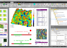
Software Description:
MountainsMap Scanning Topography is a professional application designed to perform surface analysis for 3D surface profilometers. With MountainsMap Scanning Topography, users will be able to easily analyze measurements and metrology data. It features an extensive set of surface texture parameters. ...
type: Trialware
Download MountainsMap Scanning Topographycategories: surface profilometer, scanning opography, surface analysis, topography, profilometer, surface Add to Download Basket Report virus or spyware |
 [ Zoom screenshot ] |
|
| Software Info | |
|
Best Vista Download periodically updates pricing and software information of MountainsMap Scanning Topography full version from the publisher,
but some information may be out-of-date. You should confirm all information. Software piracy is theft, using crack, warez passwords, patches, serial numbers, registration codes, key generator, keymaker or keygen for MountainsMap Scanning Topography license key is illegal and prevent future development of MountainsMap Scanning Topography. Download links are directly from our mirrors or publisher's website, MountainsMap Scanning Topography torrent files or shared files from rapidshare, yousendit or megaupload are not allowed! |
|
| Released: | September 29, 2014 |
| Filesize: | 511.00 MB |
| Platform: | Windows XP, Windows Vista, Windows Vista x64, Windows 7, Windows 7 x64 |
| Install | Instal And Uninstall |
| Add Your Review or Windows Vista Compatibility Report |
MountainsMap Scanning Topography- Releases History |
| Software: | MountainsMap Scanning Topography 6.2.6266 |
| Date Released: | May 3, 2012 |
| Status: | New Release |
| Release Notes: | Surface partitioning with or without leveling: · A sub-surface can be extracted with or without leveling using the Partition Leveling operator. Contour Analysis/Advanced Contour Analysis module enhancements: · Horizontal contour extraction with smoothing - parametric profiles extracted on the XY plane can be smoothed automatically. Integration of Chinese GB/T standards: · The "right parameters wherever you are" feature has been extended to include Chinese GB/T standard references for parameter families, which can be selected in Metrological Preferences - References. Advanced Contour Analysis module enhancements: · Automatic association of geometric elements with profiles - line segments, arcs and circles (greater than a specified minimum size) can be automatically associated with profiles. This significantly speeds up the definition of nominal form (which is otherwise carried out interactively or by fitting CAD DXF data to the profile). |
Most popular add layer in CAD downloads for Vista |
|
MountainsMap Scanning Topography 6.2.6266 download by Digital Surf
... Straightforward upgrade path to MountainsMap® Universal if you add a new type of instrument to your instrument ... example a disk fixture ring, contact zone, MEMS layer or valley region - and analyze it independently, ...
type: Trialware
View Details
Download
categories: surface profilometer, scanning opography, surface analysis, topography, profilometer, surface |
 |
|
Gerbview x64 10.21 download by Software Companions
... convert your Gerber, Excellon and HPGL files. Create layered PDF, DXF and DWF files from your Gerber ... formats. Convert multiple Gerber files to a multi layer PDF, DWF or DXF file. Query for entity ...
type: Trialware ($80.00)
View Details
Download
categories: x64 print Gerber image, view plot x64, convert Gerber x64, convert x64, Gerber x64, print x64 |
 |
|
BricsCad Classic 24.2.06-1 download by Bricsys Inc.
... applies to both linear and angular dimensions. Layer states let you save and restore configurations of layer properties and states. You might want a layer to display in blue sometimes and green at ...
View Details
Download
|
 |
|
Thuban for Windows 1.2.2 download by Thuban Development Team
... features: # Vector Data Support: Shapefile, PostGIS Layer and OGR # Raster Data Support: GeoTIFF Layer and GDAL # Comfortable Map Navigation # Object ... # Printing and Vector Export # API for Add-Ons (Extensions) # Multi-Language Support: English, French, German, Hungarian, ...
type: Open Source
View Details
Download
categories: geographic data viewer, gis viewer, analyze geographic information, information, geographic, viewer |
 |
|
Elshayal Smart 23.02 download by Elshayal Smart Web On Line Software
... jpg, bmp and Edit shape files, build new layer, add existing layer, remove layers, swap layers, save layer, set layer data source, layer properties, zoom in & zoom out, pan, identify, ...
View Details
Download
|
 |