Related Keywords
points downloadspoints import for autocad downloads
points of interest downloads
points of interest icons downloads
points in time downloads
points insertion downloads
points cloud downloads
import points downloads
access points downloads
restore points downloads
pivot points downloads
read points downloads
action points downloads
open points downloads
draw points downloads
function points downloads
xyz points downloads
microsoft points downloads
map plot points downloads
plot points downloads
Top Software Keywords
autocad downloads3d cad downloads
cad downloads
drawing downloads
import downloads
design downloads
dwg downloads
pdf to dwg downloads
dxf downloads
convert pdf to dwg downloads
convert downloads
dxf to pdf downloads
dwg to pdf downloads
converter downloads
pdf to dxf downloads
dwf to dwg downloads
dwg converter downloads
dwg to jpg downloads
dwg to dxf downloads
dwg to bmp downloads
stl downloads
dxf to pcl downloads
dwg to tiff downloads
intellicad downloads
pdf to cad downloads
dwg to gif downloads
convert dwg to pdf downloads
dwg to png downloads
dwg to dwf downloads
dxf to ps downloads
Vista Download
Vista downloadVista antivirus download
Vista wallpaper download
Vista wallpapers download
Vista themes download
Vista pack download
Vista ultimate download
Vista home download
Vista basic download
Vista business download
Vista x64 download
Vista transformation download
Vista transformation pack download
Vista boot download
Vista dvd download
Vista sidebar download
Vista aero download
Vista product key download
Downloads RSS
Top Downloads
Top Rated
Navigation: Home
\ Graphic Apps
\ CAD \ LanDTM
LanDTM6.1 by Aplicaciones Topográficas S.L. |

|
Software Description:
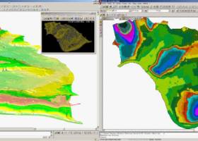
There is not any professional program on internet like this and you can get it without any effort. I think this could be a handicap because it's dificult to believe, but it's true; try it and you'll be surprised. It's not only a program to calculate a delaunay triangulation but you can input break-lines to get a real representation of the terrain. ...
type: Freeware
Download LanDTMcategories: Delaunay triangulation, Terrain Representation, CAD addon, Delaunay triangulation, Calculate, Terrain Add to Download Basket Report virus or spyware |
 [ Zoom screenshot ] |
|
| Software Info | |
|
Best Vista Download periodically updates pricing and software information of LanDTM full version from the publisher,
but some information may be out-of-date. You should confirm all information. Software piracy is theft, using crack, warez passwords, patches, serial numbers, registration codes, key generator, keymaker or keygen for LanDTM license key is illegal and prevent future development of LanDTM. Download links are directly from our mirrors or publisher's website, LanDTM torrent files or shared files from rapidshare, yousendit or megaupload are not allowed! |
|
| Released: | April 23, 2017 |
| Filesize: | 58.80 MB |
| Platform: | Windows XP, Windows Vista, Windows Vista x64, Windows 7, Windows 7 x64, Windows 8, Windows 8 x64, Windows 10, Windows 10 x64 |
| Install | Instal And Uninstall |
| Add Your Review or Windows Vista Compatibility Report |
LanDTM- Releases History |
| Software: | LanDTM 6.1 |
| Date Released: | Apr 23, 2017 |
| Status: | New Release |
| Software: | LanDTM 6.1.6 |
| Date Released: | Feb 16, 2012 |
| Status: | New Release |
| Release Notes: | · New installers of the program to 32 and 64 bits platforms. · LanDTM on BricsCAD v12. · LanDTM on Autocad 2012. · Separator/discriminator of points. · Compatibility with "gsf" grid files REDNAP of Geoid ondulation. · Elevation modification of PPuntos. · Importation/exportationn of Points to PPuntos. · Compatibility between formats. Trimble M3, GPS Trimble, GSI of Stonex. |
| Software: | LanDTM 6.1.5 |
| Date Released: | Oct 5, 2011 |
| Status: | New Release |
| Release Notes: | · You can digitalize lines and points in Google Earth and export them to the CAD. It Works in BricsCAD v11. |
Most popular 2 points in CAD downloads for Vista |
|
BricsCad Classic 24.2.06-1 download by Bricsys Inc.
... BricsCad, Dimensions can be linked to entity snap points such as endpoints, midpoints and perpendicular. Associative dimensioning applies to both linear and angular dimensions. Layer states let you save ...
View Details
Download
|
 |
|
Pro Yacht 1.0.0.1 download by Marcus Bole
... polyline processing functions which allow the distribution of points and section curves to be adjusted, reducing complexity so that the data can be used for hydrodyamic analysis. For the expert ...
type: Freeware
View Details
Download
categories: calculate hydrostatic coefficient, ship displacement, design ship hull, ship, design, create |
 |
|
QCAD 3.29.3 download by RibbonSoft, GmbH
... Over 20 modification tools Construction and modification of points, lines, arcs, circles, ellipses, splines, polylines, texts, dimensions, hatches, fills, raster images Various powerful entity selection tools Object snaps Measuring tools ...
type: Demo ($38.00)
View Details
Download
categories: CAD software, schematics software, CAD drawing, CAD, schematics, DWG |
 |
|
GOM Inspect 7.5 SR1 download by GOM
... best-fit and hierarchical alignments CAD comparison: surface, sections, points, ... CAD-based primitive generation: lines, planes, circles, cylinders, cones, ... 2D section-based analysis Inspection functions: dimensions, virtual calipers, angles, diameters, ... ...
View Details
Download
|
 |
|
GC-PrevuePlus 21.2 download by GraphiCode Inc.
... a measure tool to find distances between data points, ability to fix polygon data errors commonly found in DXF and DWG files, drill drawing creation, streamlined data translation between various ...
type: Trialware ($400.00)
View Details
Download
categories: view PCB design, circuit board editor, DXF converter, view, viewer, Gerber |
 |
|
IGES Viewer alias ABViewer 14 download by CADSoftTools
... between two parallel surfaces, the distance between two points, length of an edge and radius of a circle or a circular arc. Results of measurements are displayed in the special ...
type: Shareware ($66.00)
View Details
Download
categories: IGS, IGES, .igs, IGS viewer, 3D viewer, IGS to DWG, IGS to STL, IGS to JPEG, IGS to OBJ, IGS to DXF, convert, converter, measure, measuring, view, viewer, print, printing |
 |
|
GGCad 2.1.0.5 download by GGSoft
... be able to draw different shapes such as points, lines, circles, arcs, ellipses, text and splines. Moreover, you will have the transformation tools such as rotation, symmetry, scale, translation. Spur ...
View Details
Download
|
 |
|
TopoLT 15.2 download by CADWARE Engineering
... cadastre projects. FEATURES: · draws directly points from coordinate files, draws coordinates from total station ... codes interpretation file defined by the user; · points can be graphically drawn with or without elevations, ...
type: Trialware ($600.00)
View Details
Download
categories: topographical plan, cadastral plan, terrain model, topography, cadaster, terrain |
 |
|
UCL Depthmap 0.8.0 download by University College London
... of isovists into a visibility graph of intervisible points (with graphs of up to about 1000000 point locations). The visibility graph may then be analysed directly using graph measures, or ...
type: Open Source
View Details
Download
categories: urban environment, urban map, spatial network analysis, environment, map, analysis |
 |
|
Maxsurf 17.07 download by Bentley Systems
... to match desired dimensions and hydrostatic properties. Control points can be dragged with the mouse, adjusted numerically, or manipulated by a range of fairing commands. FEATURES: · Fast ...
View Details
Download
|
|